
File:1858 Mexico Map Civil War Divisions.svg

Size of this PNG preview of this SVG file: 700 × 448 pixels. Other resolutions: 320 × 205 pixels | 640 × 410 pixels | 1,024 × 655 pixels | 1,280 × 819 pixels | 2,560 × 1,638 pixels.
Original file (SVG file, nominally 700 × 448 pixels, file size: 1.44 MB)
| This is a file from the Wikimedia Commons. Information from its description page there is shown below. Commons is a freely licensed media file repository. You can help. |
Summary
| Description |
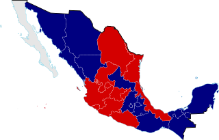
English: Mexico Civil War Division Map in 1858, the Mexican Civil War was one of the episodes of the long struggle between Liberal and Conservative forces that dominated the country's history in the 19th century, because the Liberals wanted a federalist government, limiting traditional Catholic Church and military influence in the country, meanwhile the Conservatives wanted a centralist government, even a monarchy with the Church and military keeping their traditional roles and powers. |
||
| Date | |||
| Source |
Conservative support
Liberal support
Independent
|
||
| Author | Giggette | ||
| Attribution (required by the license) | © Giggette / Wikimedia Commons / | ||
| SVG development |
| Camera location | | View this and other nearby images on: OpenStreetMap |
|---|
Licensing
I, the copyright holder of this work, hereby publish it under the following licenses:
This file is licensed under the Creative Commons Attribution-Share Alike 3.0 Unported license.
- You are free:
- to share – to copy, distribute and transmit the work
- to remix – to adapt the work
- Under the following conditions:
- attribution – You must give appropriate credit, provide a link to the license, and indicate if changes were made. You may do so in any reasonable manner, but not in any way that suggests the licensor endorses you or your use.
- share alike – If you remix, transform, or build upon the material, you must distribute your contributions under the same or compatible license as the original.

|
Permission is granted to copy, distribute and/or modify this document under the terms of the GNU Free Documentation License, Version 1.2 or any later version published by the Free Software Foundation; with no Invariant Sections, no Front-Cover Texts, and no Back-Cover Texts. A copy of the license is included in the section entitled GNU Free Documentation License. |
You may select the license of your choice.
File history
Click on a date/time to view the file as it appeared at that time.
| Date/Time | Thumbnail | Dimensions | User | Comment | |
|---|---|---|---|---|---|
| current | 21:07, 24 May 2013 | | 700 × 448 (1.44 MB) | Giggette | Veracruz |
| 18:36, 24 May 2013 |  | 700 × 448 (946 KB) | Giggette | {{Information |Description ={{en|1=c}} |Source ={{own}} |Author =Giggette |Date = |Permission = |other_versions = }} Category:SVG maps of Mexico |
File usage
The following pages on the English Wikipedia use this file (pages on other projects are not listed):
Global file usage
The following other wikis use this file:
- Usage on af.wikipedia.org
- Usage on ar.wikipedia.org
- Usage on br.wikipedia.org
- Usage on es.wikipedia.org
- Usage on ka.wikipedia.org
- Usage on nah.wikipedia.org
- Usage on no.wikipedia.org
- Usage on ro.wikipedia.org
- Usage on ru.wikipedia.org
- Usage on tr.wikipedia.org
- Usage on uk.wikipedia.org
- Usage on www.wikidata.org