
File:1855 Spruner Map of Australia and Polynesia with an overview of Discoveries and Colonization - Geographicus - AustraliaPolynesia-spruner-1855.jpg

Size of this preview: 739 × 599 pixels. Other resolutions: 296 × 240 pixels | 592 × 480 pixels | 947 × 768 pixels | 1,263 × 1,024 pixels | 2,526 × 2,048 pixels | 3,500 × 2,838 pixels.
Original file (3,500 × 2,838 pixels, file size: 1.88 MB, MIME type: image/jpeg)
| This is a file from the Wikimedia Commons. Information from its description page there is shown below. Commons is a freely licensed media file repository. You can help. |
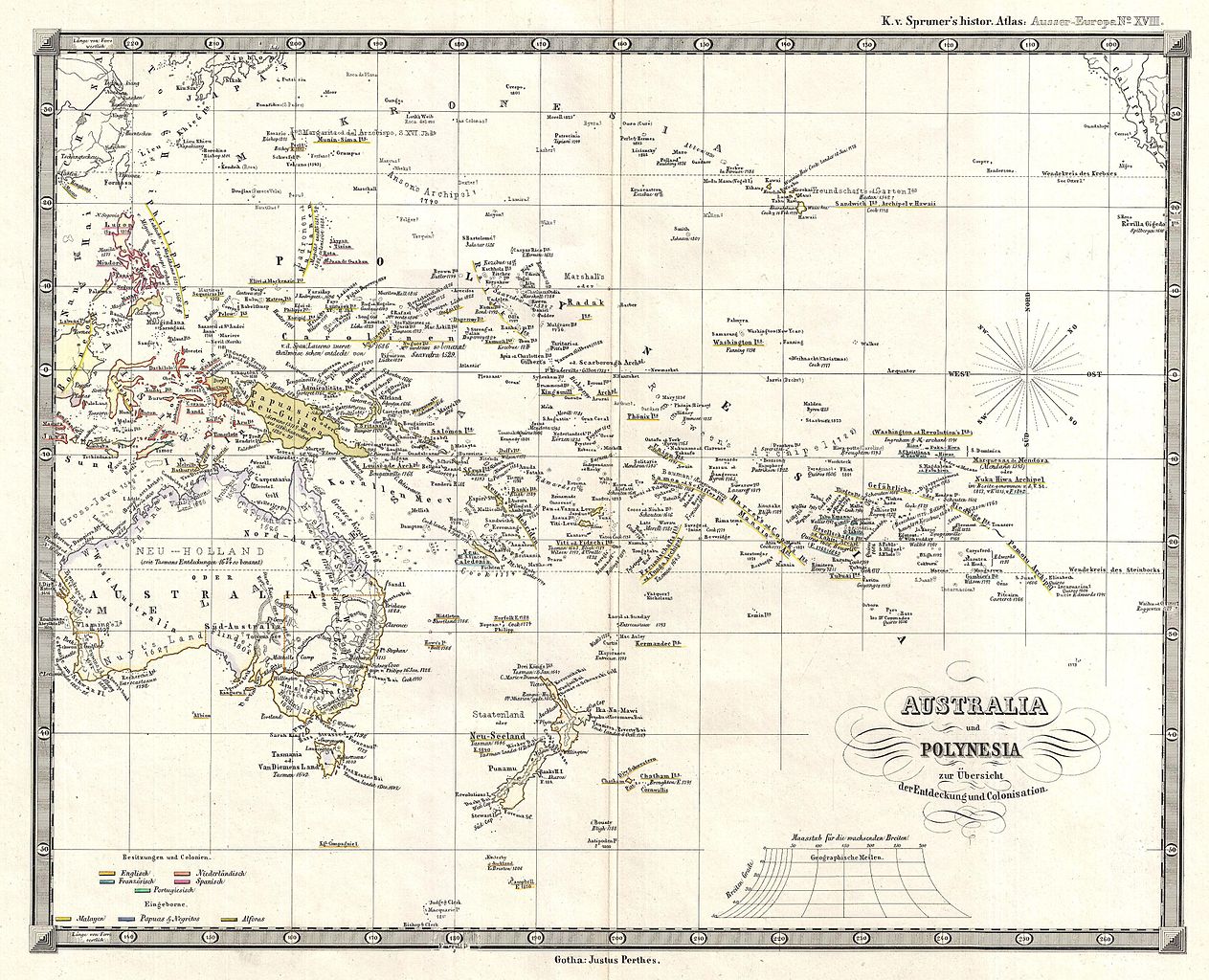
| Karl Spruner von Merz: Australia und Polynesia zur Ubersicht der Entdeckung und Colonisation
( |
||||||||||||||||||||
|---|---|---|---|---|---|---|---|---|---|---|---|---|---|---|---|---|---|---|---|---|
| Artist |
|
|||||||||||||||||||
| Title |
Australia und Polynesia zur Ubersicht der Entdeckung und Colonisation |
|||||||||||||||||||
| Description |
English: This is Karl von Spruner’s 1855 historical map of Australia and Polynesia, with an overview of discoveries and colonization. Covers the area from Australia to California (in the upper right corner), and from China and Japan in the north to New Zealand, Auckland and Macquarie Islands in the south. Dates of discovery and discoverers names appear throughout, making this map is invaluable to anyone researching the history of discovery in Polynesia and Melanesia. Relief is shown by hachures, and the whole is rendered in finely engraved detail exhibiting throughout the fine craftsmanship for which the Perthes firm is best known. Justus Perthes published the map as plate number 18 in Dr. Karl von Spruner's 1855 Historisch-Geographischer Hand-Atlas zur Geschichte Asiens, Africa’s, America’s und Australiens , also known as Histor. Atlas. Ausser Europa . |
|||||||||||||||||||
| Date | 1855 (undated) | |||||||||||||||||||
| Dimensions | height: 12.2 in (31.1 cm); width: 15 in (38.1 cm) | |||||||||||||||||||
| Accession number |
Geographicus link: AustraliaPolynesia-spruner-1855 |
|||||||||||||||||||
| Source/Photographer |
Spruner, Karl von, Historisch-Geographischer Hand-Atlas zur Geschichte Asiens, Africa's, America's und Australiens. (Gotha: Justus Perthes), 1855.
|
|||||||||||||||||||
| Permission (Reusing this file) |
|
|||||||||||||||||||
| Other versions | ||||||||||||||||||||

| Annotations | This image is annotated: View the annotations at Commons |
File history
Click on a date/time to view the file as it appeared at that time.
| Date/Time | Thumbnail | Dimensions | User | Comment | |
|---|---|---|---|---|---|
| current | 07:42, 25 March 2011 | | 3,500 × 2,838 (1.88 MB) | BotMultichillT | {{subst:User:Multichill/Geographicus |link=http://www.geographicus.com/P/AntiqueMap/AustraliaPolynesia-spruner-1855 |product_name=1855 Spruner Map of Australia and Polynesia with an overview of Discoveries and Colonization |map_title=Australia und Polynes |
File usage
The following pages on the English Wikipedia use this file (pages on other projects are not listed):
Global file usage
The following other wikis use this file:
- Usage on fr.wikipedia.org
- Usage on ja.wikipedia.org