
File:1825 Map of Mrauk-U.jpg

Size of this preview: 800 × 580 pixels. Other resolutions: 320 × 232 pixels | 640 × 464 pixels | 1,024 × 742 pixels | 1,280 × 928 pixels | 1,976 × 1,432 pixels.
Original file (1,976 × 1,432 pixels, file size: 657 KB, MIME type: image/jpeg)
| This is a file from the Wikimedia Commons. Information from its description page there is shown below. Commons is a freely licensed media file repository. You can help. |
Summary
| Description |
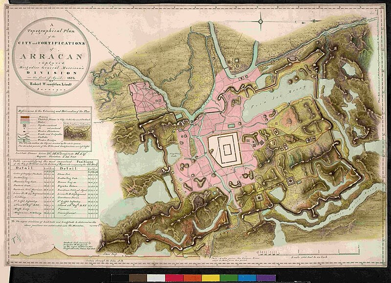
English: A Topographical Plan of the City and Fortifications of Arracan(Arakan) or Mrauk-U by Brigade General Joseph Wanton Morrison, British Army in 1825 |
| Date | |
| Source | Own work |
| Author | Arezarni |
| Camera location | | View this and other nearby images on: OpenStreetMap |
|---|
Licensing
I, the copyright holder of this work, hereby publish it under the following license:
This file is licensed under the Creative Commons Attribution-Share Alike 4.0 International license.
- You are free:
- to share – to copy, distribute and transmit the work
- to remix – to adapt the work
- Under the following conditions:
- attribution – You must give appropriate credit, provide a link to the license, and indicate if changes were made. You may do so in any reasonable manner, but not in any way that suggests the licensor endorses you or your use.
- share alike – If you remix, transform, or build upon the material, you must distribute your contributions under the same or compatible license as the original.
| This file was uploaded via Mobile Android App (Commons mobile app) 4.2.1~14b6c455b. |
File history
Click on a date/time to view the file as it appeared at that time.
| Date/Time | Thumbnail | Dimensions | User | Comment | |
|---|---|---|---|---|---|
| current | 09:57, 9 December 2023 | | 1,976 × 1,432 (657 KB) | Arezarni | Uploaded using Commons Mobile App |
File usage
The following pages on the English Wikipedia use this file (pages on other projects are not listed):