
File:1770 Bonne Map of East Africa, Madagascar, Isle Bourbon and Mauritius (Mozambique) - Geographicus - AfricaEast-bonne-1770.jpg

Size of this preview: 800 × 592 pixels. Other resolutions: 320 × 237 pixels | 640 × 474 pixels | 1,024 × 758 pixels | 1,280 × 947 pixels | 2,560 × 1,894 pixels | 4,000 × 2,960 pixels.
Original file (4,000 × 2,960 pixels, file size: 2.89 MB, MIME type: image/jpeg)
| This is a file from the Wikimedia Commons. Information from its description page there is shown below. Commons is a freely licensed media file repository. You can help. |
_-_Geographicus_-_AfricaEast-bonne-1770.jpg)
| Rigobert Bonne: Partie de la Cote Orientale D'Afrique avec L'Isle de Madagascar et les Cartes particulieres des Isles de France et de Bourbon.
( |
|||||||||||||||||||||||
|---|---|---|---|---|---|---|---|---|---|---|---|---|---|---|---|---|---|---|---|---|---|---|---|
| Artist |
|
||||||||||||||||||||||
| Title |
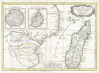
Partie de la Cote Orientale D'Afrique avec L'Isle de Madagascar et les Cartes particulieres des Isles de France et de Bourbon. |
||||||||||||||||||||||
| Description |
English: A beautiful example of Rigobert Bonne's c. 1770 decorative map of southeastern Africa and Madagasgar. Roughly covers the territory current incorporated into Mozambique and Madagascar. Also includes inset map of the Isle Bourbon and Isle de France or Mauritius. This region of Africa held a particular fascination for Europeans since the Portuguese first encountered it in the 16th century. At the time, this area was a vast empire called Mutapa or Monomotapa that maintained an active trading network with faraway partners in India and Asia. As the Portuguese presence in the area increased in the 17th century, the Europeans began to note that Monomatapa was particularly rich in gold. They were also impressed with the numerous well crafted stone structures, including the mysterious nearby ruins of Great Zimbabwe. This combination led many Europeans to believe that King Solomon's mines must be hidden in this region. Sure enough our map shows the Mts. Fuca riches en Or in the western parts of Monomotapa. Monomotapa did in fact have rich gold mines in the 16th and 17th centuries, but most have these had been exhausted by the 1700s. A decorative title cartouche appears in the upper right hand quadrant. Drawn by R. Bonne in 1770 for issue as plate no. C. 30 in Jean Lattre's 1776 issue of the Atlas Moderne . |
||||||||||||||||||||||
| Date | 1770 (undated) | ||||||||||||||||||||||
| Dimensions | height: 12 in (30.4 cm); width: 16.5 in (41.9 cm) | ||||||||||||||||||||||
| Accession number |
Geographicus link: AfricaEast-bonne-1770 |
||||||||||||||||||||||
| Source/Photographer |
Lattre, Jean, Atlas Moderne ou Collection de Cartes sur Toutes les Parties du Globe Terrestre, c. 1775.
|
||||||||||||||||||||||
| Permission (Reusing this file) |
|
||||||||||||||||||||||
File history
Click on a date/time to view the file as it appeared at that time.
| Date/Time | Thumbnail | Dimensions | User | Comment | |
|---|---|---|---|---|---|
| current | 03:15, 23 March 2011 | | 4,000 × 2,960 (2.89 MB) | BotMultichillT | {{subst:User:Multichill/Geographicus |link=http://www.geographicus.com/P/AntiqueMap/AfricaEast-bonne-1770 |product_name=1770 Bonne Map of East Africa, Madagascar, Isle Bourbon and Mauritius (Mozambique) |map_title=Partie de la Cote Orientale D'Afrique ave |
File usage
No pages on the English Wikipedia use this file (pages on other projects are not listed).
Global file usage
The following other wikis use this file:
- Usage on cs.wikipedia.org
- Usage on tum.wikipedia.org
- Usage on uk.wikipedia.org
_-_Geographicus_-_AfricaEast-bonne-1770.jpg)