File:1744 Wren Map of London, England - Geographicus - London-wren-1744.jpg
Page contents not supported in other languages.
This is a file from the Wikimedia Commons
From Wikipedia, the free encyclopedia

Original file(5,000 × 3,496 pixels, file size: 4.43 MB, MIME type: image/jpeg)

Christopher Wren: Ichnographia urbis Londinii… (A Plan of the City of London, after the great FIRE, in the Year of Our Lord 1666.)   (Wikidata search (Cirrus search) Wikidata query (SPARQL)  Create new Wikidata item based on this file)
Artist
Christopher Wren  (1632–1723)  wikidata:Q170373 s:en:Author:Christopher Michael Wren q:en:Christopher Wren
 
Christopher Wren
Alternative names
Sir Christopher Wren
Description British architect, astronomer, mathematician, physicist, anatomist and university teacher
Date of birth/death 20 October 1632 (in Julian calendarEdit this at Wikidata 25 February 1723 (in Julian calendarEdit this at Wikidata
Location of birth/death East Knoyle London
Work period 1657-1710
Work location
Authority file
artist QS:P170,Q170373
Title
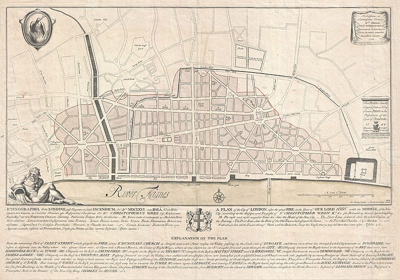
Ichnographia urbis Londinii… (A Plan of the City of London, after the great FIRE, in the Year of Our Lord 1666.)
Description
English: An extremely scarce 1744 map of London showing Sir Christopher Wren's plan for reconstructing the city following the 1666 Great Fire of London. In 1666 the Great Fire swept through the old Roman portions of London, laying waste to most of the original walled city. Christopher Wren, a well known architect of the period was quick to respond to the disaster as a opportunity to dramatically redesign and modernize London's center. Wren having been schooled in Paris envisioned an elaborate classically influenced reconstruction of the city with broad avenues meeting in a series of Piazzas. Despite, or perhaps because of, Wren's promptitude in producing a plan for a major post-fire reconstruction, his plan exhibits a number of dramatic errors. Wren did not take the city's topography into account and consequently much of the this plan is unfeasible. Despite claims to the contrary in the document itself, Wren's plan was never seriously considered by either the King or the Parliament. Today Wren's original 1666 plan is lost. This version was drawn in 1744 by the once fashionable engrave P. Fourdrinier, who claims to have replicated exactly a scarce 1724 original owned by the Earl of Pembroke. This map covers London along the north side of the Thames River from Strand Bridge to Great Tower Hill. Shows Wren's detailed reconstruction plan, along with the regions originally destroyed by the Great Fire. Identifies the proposed locations of parochial churches, markets, piazzas, bridges and warehouses. A vignette in the lower left quadrant depicts Thamesis, the river god for which the Thames River is named. The upper left quadrant bears the image of a phoenix, suggesting that, like the mythical bird, London too would rise from its own ashes and be reborn in fire. The lower quadrants of this plate include the map's title in both English and Latin as well as a detailed Explanation of the Plan. This plan is highly uncommon and rarely appears outside of institutional collections.
Date 1744 (dated)
Dimensions height: 19 in (48.2 cm); width: 27.5 in (69.8 cm)
dimensions QS:P2048,19U218593
dimensions QS:P2049,27.5U218593
Accession number
Geographicus link: London-wren-1744
Source/Photographer
Permission
(Reusing this file)
This is a faithful photographic reproduction of a two-dimensional, public domain work of art. The work of art itself is in the public domain for the following reason:
Public domain

This work is in the public domain in its country of origin and other countries and areas where the copyright term is the author's life plus 100 years or fewer.


You must also include a United States public domain tag to indicate why this work is in the public domain in the United States.
The official position taken by the Wikimedia Foundation is that "faithful reproductions of two-dimensional public domain works of art are public domain".
This photographic reproduction is therefore also considered to be in the public domain in the United States. In other jurisdictions, re-use of this content may be restricted; see Reuse of PD-Art photographs for details.
Public domain
This work is in the public domain in the United States because it was published (or registered with the U.S. Copyright Office) before January 1, 1929.

Public domain works must be out of copyright in both the United States and in the source country of the work in order to be hosted on the Commons. If the work is not a U.S. work, the file must have an additional copyright tag indicating the copyright status in the source country.
Note: This tag should not be used for sound recordings.PD-1923Public domain in the United States//commons.wikimedia.org/wiki/File:1744_Wren_Map_of_London,_England_-_Geographicus_-_London-wren-1744.jpg

Captions

Add a one-line explanation of what this file represents

Elementos representados en este archivo

depicts

image/jpeg

aac4573c33ddccb69d1cadc3765e753878fd91b4

4,649,137 byte

3,496 pixel

5,000 pixel

File history

Click on a date/time to view the file as it appeared at that time.

Date/TimeThumbnailDimensionsUserComment
current20:42, 23 March 2011Thumbnail for version as of 20:42, 23 March 20115,000 × 3,496 (4.43 MB)BotMultichillT{{subst:User:Multichill/Geographicus |link=http://www.geographicus.com/P/AntiqueMap/London-wren-1744 |product_name=1744 Wren Map of London, England |map_title=Ichnographia urbis Londinii… (A Plan of the City of London, after the great FIRE, in the Year
The following pages on the English Wikipedia use this file (pages on other projects are not listed):

Global file usage

The following other wikis use this file: