
File:1646linemap.jpg
No higher resolution available.
1646linemap.jpg (300 × 250 pixels, file size: 19 KB, MIME type: image/jpeg)
| This is a file from the Wikimedia Commons. Information from its description page there is shown below. Commons is a freely licensed media file repository. You can help. |

|
This map image could be re-created using vector graphics as an SVG file. This has several advantages; see Commons:Media for cleanup for more information. If an SVG form of this image is available, please upload it and afterwards replace this template with
{{vector version available|new image name}}.
It is recommended to name the SVG file “1646linemap.svg”—then the template Vector version available (or Vva) does not need the new image name parameter. |


Summary
| Description |
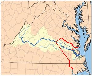
English: Self-Made from Jamesrivermap.jpg, red line shows boundary between Virginia Colony and Tributary Indian tribes as established by Treaty of 1646 concluding Second Anglo-Powhatan War. Red dot on river shows Jamestown, capital of Virginia Colony. |
| Date | 10 March 2009 (original upload date) |
| Source | Transferred from en.wikipedia to Commons by The Bushranger using CommonsHelper. |
| Author | Til Eulenspiegel at English Wikipedia |
Licensing
| This work has been released into the public domain by its author, Til Eulenspiegel at English Wikipedia. This applies worldwide. In some countries this may not be legally possible; if so: Til Eulenspiegel grants anyone the right to use this work for any purpose, without any conditions, unless such conditions are required by law. |
Original upload log
The original description page was here. All following user names refer to en.wikipedia.
- 2009-03-10 13:56 Til Eulenspiegel 300×250 (19099 bytes) Self-Made from Jamesrivermap.jpg, red line shows boundary between [[Virginia Colony]] and Tributary Indian tribes as established by Treaty of 1646 concluding [[Second Anglo-Powhatan War]]. Red dot shows Jamestown, capital of Virginia Colony.
File history
Click on a date/time to view the file as it appeared at that time.
| Date/Time | Thumbnail | Dimensions | User | Comment | |
|---|---|---|---|---|---|
| current | 15:56, 1 January 2012 | | 300 × 250 (19 KB) | File Upload Bot (Magnus Manske) | {{BotMoveToCommons|en.wikipedia|year={{subst:CURRENTYEAR}}|month={{subst:CURRENTMONTHNAME}}|day={{subst:CURRENTDAY}}}} {{Information |Description={{en|Self-Made from Jamesrivermap.jpg, red line shows boundary between en:Virginia Colony and Tributar |
File usage
The following pages on the English Wikipedia use this file (pages on other projects are not listed):
Global file usage
The following other wikis use this file:
- Usage on fr.wikipedia.org
- Usage on hy.wikipedia.org