
File:1596 Gadner Übersicht Herzogtum LABW HStA Stuttgart Blatt 4 Bild 1Web.jpg

Size of this preview: 596 × 599 pixels. Other resolutions: 239 × 240 pixels | 477 × 480 pixels | 764 × 768 pixels | 1,018 × 1,024 pixels | 2,381 × 2,394 pixels.
Original file (2,381 × 2,394 pixels, file size: 6.27 MB, MIME type: image/jpeg)
| This is a file from the Wikimedia Commons. Information from its description page there is shown below. Commons is a freely licensed media file repository. You can help. |
Summary
| Description |
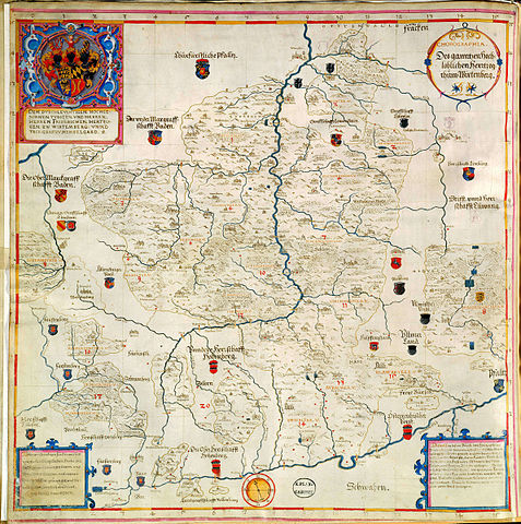
Deutsch: Übersichtskarte zu den Gadnerschen Forstkarten: „Chorographia Beschreibung des hochlöblichen Hertzogtum Wirtenberg samt allen desselben Landschaften, Ämtern, Städten, Klöstern, Schlössern, Flecken, Dörfern, Wassern, Flüssen, Bächen, Forsten, Wäldern, Gebirgen und Hölzern. Desgleichen mit den Anstössern und Grenzen. Wie auch mit den darin gelegenen geistlichen und adeligen Gütern“ |
||||||||||||||||||||||
| Date | |||||||||||||||||||||||
| Source | LABW, Hauptstaatsarchiv Stgt., N 3 Nr. 1/2 | ||||||||||||||||||||||
| Author |
|
||||||||||||||||||||||
Licensing
I, the copyright holder of this work, hereby publish it under the following license:
This file is licensed under the Creative Commons Attribution-Share Alike 3.0 Unported license.
- You are free:
- to share – to copy, distribute and transmit the work
- to remix – to adapt the work
- Under the following conditions:
- attribution – You must give appropriate credit, provide a link to the license, and indicate if changes were made. You may do so in any reasonable manner, but not in any way that suggests the licensor endorses you or your use.
- share alike – If you remix, transform, or build upon the material, you must distribute your contributions under the same or compatible license as the original.
File history
Click on a date/time to view the file as it appeared at that time.
| Date/Time | Thumbnail | Dimensions | User | Comment | |
|---|---|---|---|---|---|
| current | 01:44, 28 June 2015 | | 2,381 × 2,394 (6.27 MB) | Grüninger | {{Information |Description ={{de|1=Übersichtskarte zu den Gadnerschen Forstkarten: „Chorographia Beschreibung des hochlöblichen Hertzogtum Wirtenberg samt allen desselben Landschaften, Ämtern, Städten, Klöstern, Schlössern, Flecken, Dörfern... |
File usage
The following pages on the English Wikipedia use this file (pages on other projects are not listed):
Global file usage
The following other wikis use this file:
- Usage on de.wikipedia.org
- Usage on la.wikipedia.org
- Usage on ru.wikipedia.org