
File:1558 Hollandt v Deventer.jpg

Size of this preview: 451 × 599 pixels. Other resolutions: 181 × 240 pixels | 361 × 480 pixels | 578 × 768 pixels | 771 × 1,024 pixels | 1,542 × 2,048 pixels | 2,820 × 3,746 pixels.
Original file (2,820 × 3,746 pixels, file size: 9.63 MB, MIME type: image/jpeg)
| This is a file from the Wikimedia Commons. Information from its description page there is shown below. Commons is a freely licensed media file repository. You can help. |
Summary
| Description |
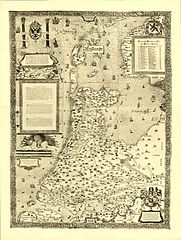
English: Map of Holland, The Netherlands.
Nederlands: Kaart van Holland, Nederland.
Wandkaart van Noord- en Zuid-Holland e.o., in kaart gebracht door Jacob van Deventer in 1537 en gedrukt bij Bernard van den Putte in Antwerpen, 19 februari 1558. Deze 4-blads kaart (genummerd 5, 6, 7, 8) is afkomstig uit de facsimile-editie "De kaarten van de Nederlandsche provinciën" van Jacob van Deventer, uit de zestiende eeuw. De oorspronkelijke houtsnede-kaart bestaande uit 9 deelbladen bevond zich in de Stadsbiblioteek van Wroclaw (Bleslau), maar is in 1945 verloren gegaan. In 1994 is bij Canaletto te Alphen aan den Rijn opnieuw een facsimile van deze zo belangrijke gewestkaarten van Van Deventer verschenen, met een inleiding van C. Koeman. |
|||||||||||||||||||||||
| Date | from 1537 until 1558 | |||||||||||||||||||||||
| Source | Nationaal Archief ; Aan elkaar geplakte screenshots | |||||||||||||||||||||||
| Author |
|
|||||||||||||||||||||||
Licensing
|
This work is in the public domain in its country of origin and other countries and areas where the copyright term is the author's life plus 100 years or fewer. | |
| This file has been identified as being free of known restrictions under copyright law, including all related and neighboring rights. | |
File history
Click on a date/time to view the file as it appeared at that time.
| Date/Time | Thumbnail | Dimensions | User | Comment | |
|---|---|---|---|---|---|
| current | 10:56, 13 November 2009 | | 2,820 × 3,746 (9.63 MB) | Joopr | {{Information |Description={{en|1=Map of Holland, The Netherlands}} {{nl|1=Kaart van Holland, Nederland}} |Source=http://beeldbank.nationaalarchief.nl/nl/afbeeldingen/indeling/detail/sortering/relevantie/start/23/q/zoekveld/van%20deventer/trefwoord/Materi |
File usage
The following pages on the English Wikipedia use this file (pages on other projects are not listed):
Global file usage
The following other wikis use this file:
- Usage on fr.wikipedia.org
- Usage on fy.wikipedia.org
- Usage on he.wikipedia.org
- Usage on ko.wikipedia.org
- Usage on nl.wikipedia.org
- Usage on sl.wikipedia.org