
File:'Westward The Course of Empire Takes Its Way' Laying Track 600 Miles West of St. Louis, Missouri, October 19, 1867.jpg

Original file (6,652 × 5,364 pixels, file size: 33.03 MB, MIME type: image/jpeg)
| This is a file from the Wikimedia Commons. Information from its description page there is shown below. Commons is a freely licensed media file repository. You can help. |
Summary
| Description |
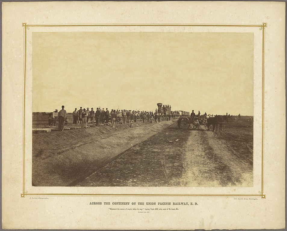
English: Across the Continent on the Union Pacific Railway, E. D.
Albumen silver print; 33.2 x 47.6 cm (13 1/16 x 18 3/4 in.); 84.XM.1027.37 The J. Paul Getty Museum, Los Angeles This is one of two Gardner photographs of the same location on the same day. Two pieces of wood and wagon tracks in the burnt grass confirm that these are of the same location. The consist is of the train is the same in both photographs. Although the other photograph (the one with the horse team at the head of the work crew on the left) is described in some sources as being taken tens of miles west of Hays, Kansas (Ogallah, 20 miles west of Hays,[1][2] for example) both photographs are of the same location just outside of present-day Hays. This photo shows the tree gallery of Big Creek nearer on the left and off in the distance on the right, the tracks having bridged the creek in between. This location is not so far west of Hays that the base of the Fort Hays bluffs would be visible the right. This location is on a flood plain, while by Ogallah, the track is on a broad, high ridge. Gardner's photograph of the bluffs 5 miles west of the Hays City station taken on the same excursion shows that the end of tracks is not that far west (the far bluff is the location of the future Yocemento). The autobiographies of Buffalo Bill and Major George Augustus Armes relate the months suspension of construction of the railroad west of Hays City due to hostilities with the Cheyenne and Arapaho at this time. The Gardner photograph "Construction train, west of Hays City" is of the same train, but with the locomotive and water tank car shifted off. The town site of Rome is behind the far right of the cars and has been largely abandoned by this time; only a few structures remain. Note the burnt grass in all pictures. This location is likely 2.7 miles west of the original Hays City station (which was near the present grain elevator) or about 1.7 miles west of the Big Creek bridge. This the present location of the Prairie Acres neighborhood. |
| Date | |
| Source | http://www.getty.edu/museum/media/images/web/download/06725201.jpg |
| Author | Alexander Gardner |
.jpg)
See also
Westward the Course of Empire Takes Its Way, an 1861 painting by Emanuel Leutze
Licensing
|
This work is in the public domain in its country of origin and other countries and areas where the copyright term is the author's life plus 70 years or fewer. This work is in the public domain in the United States because it was published (or registered with the U.S. Copyright Office) before January 1, 1929. | |
| This file has been identified as being free of known restrictions under copyright law, including all related and neighboring rights. | |
- ↑ Robert Collins (1998) Kansas Pacific, An Illustrated History, p. 15
- ↑ Alexander Gardner (1867). "Westward, the course of Empire takes its way," Laying Track. 600 miles west of St. Louis, Mo.. Kansas Memory, Kansas Historical Society. Retrieved on 2018-07-20.
File history
Click on a date/time to view the file as it appeared at that time.
| Date/Time | Thumbnail | Dimensions | User | Comment | |
|---|---|---|---|---|---|
| current | 03:31, 21 July 2018 | | 6,652 × 5,364 (33.03 MB) | IveGoneAway | User created page with UploadWizard |