
File:"Hut 8", Bletchley Park - geograph.org.uk - 1592862.jpg
No higher resolution available.
"Hut_8",_Bletchley_Park_-_geograph.org.uk_-_1592862.jpg (640 × 491 pixels, file size: 65 KB, MIME type: image/jpeg)
| This is a file from the Wikimedia Commons. Information from its description page there is shown below. Commons is a freely licensed media file repository. You can help. |
Summary
| Description |
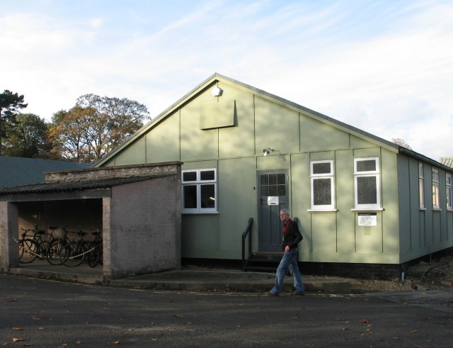
English: "Hut 8", Bletchley Park. Originally the home of the financier and Liberal MP, Sir Herbert Samuel Leon (1850-1926), the Bletchley Park estate passed out of the Leon family in 1937. During World War II the estate became the site of the UK's main decryption effort, becoming known as Station X. It was here that the codes and ciphers of several Axis countries were decrypted, most important being the ciphers generated by the German Enigma and Lorenz machines.
Some 9,000 people were working at Bletchley Park at the height of the code-breaking efforts, many of the teams being housed in temporary huts designated by numbers - Hut 8, shown here, housed the Bletchley Park team tasked with breaking into German naval wireless traffic encrypted using the Enigma machine. See also. . . .
1592868; 1592873; 1592906; 1592914; 1592920; 1593071 |
|
| Date |
|
|
| Source |
Geograph Britain and Ireland |
|
| Author |
Ian Petticrew |
|date=2009-10-31 |source=From geograph.org.uk |author=Ian Petticrew |permission= |other_versions= }}
| Object location | | View this and other nearby images on: OpenStreetMap |
|---|
_&language=en)
Licensing

|
This image was taken from the Geograph project collection. See this photograph's page on the Geograph website for the photographer's contact details. The copyright on this image is owned by Ian Petticrew and is licensed for reuse under the Creative Commons Attribution-ShareAlike 2.0 license.
|
This file is licensed under the Creative Commons Attribution-Share Alike 2.0 Generic license.
Attribution: Ian Petticrew
- You are free:
- to share – to copy, distribute and transmit the work
- to remix – to adapt the work
- Under the following conditions:
- attribution – You must give appropriate credit, provide a link to the license, and indicate if changes were made. You may do so in any reasonable manner, but not in any way that suggests the licensor endorses you or your use.
- share alike – If you remix, transform, or build upon the material, you must distribute your contributions under the same or compatible license as the original.
File history
Click on a date/time to view the file as it appeared at that time.
| Date/Time | Thumbnail | Dimensions | User | Comment | |
|---|---|---|---|---|---|
| current | 02:20, 4 March 2011 | | 640 × 491 (65 KB) | GeographBot | == {{int:filedesc}} == {{Information |description={{en|1="Hut 8", Bletchley Park Originally the home of the financier and Liberal MP, Sir Herbert Samuel Leon (18501926), the Bletchley Park estate passed out of the Leon family in 1937. During World War I |
File usage
The following pages on the English Wikipedia use this file (pages on other projects are not listed):
Global file usage
The following other wikis use this file:
- Usage on eu.wikipedia.org