
Altagracia
Altagracia
Astagalpa | |
|---|---|
Municipality | |
 Sculpture park next to the cathedral of Altagracia | |
 Altagracia Location in Nicaragua | |
| Coordinates: 11°34′N 85°35′W / 11.567°N 85.583°W | |
| Country | |
| Department | Rivas Department |
| Area | |
| • Municipality | 81 sq mi (211 km2) |
| Population (2005) | |
| • Municipality | 19,955 |
| • Urban | 7,041 |
Altagracia (Spanish pronunciation: [altaˈɣɾasja]) is a municipality in the Rivas Department of Nicaragua.
It is the second largest town on the island of Ometepe. Its original name was Astagalpa, meaning ‘house of the herons’ in Nahuatl.[1] This city also has a ferry port, Puerto de Gracia, that services Granada and San Carlos near the Rio San Juan. However, due to seasonal water level fluctuations, this port and the nightly ferry crossings are often seasonally cancelled.[2]
History[edit]
Altagracia is home to a cathedral which was built in 1924. The city has recently installed a sculpture park next to the cathedral that contains important pre-Columbian art made from basalt rock. The figures are of great size, and represent human figures and their alter egos, mainly the eagle and jaguar.
Also present in Altagracia is the Museum of Ometepe (Museo de Ometepe) with a large archaeological and ethnographic collection.
Tradition[edit]
The city patron is San Diego de Alcalá and his festival, Fiesta de San Diego, is celebrated from November 12–18.[1] The traditional dance called baile del Zompopo is performed on the 17th of November. This tradition is mixed with the celebration of Xolotl, who inhabited Nicaragua in pre-Columbian times before the Spaniards arrived. When the Franciscan arrived in Ometepe in 1613, this tradition was already existent, although they brought with themselves an image of San Diego de Alcalá and with time they obtained his figure and replaced Xolotl.
Gallery[edit]
-
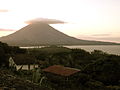 View from Finca Magdalena in Altagracia, Rivas. The Concepción volcano in the background.
 -
 Playa Santo Domingo. The Maderas volcano in the background.
 -
 Ojo de Agua, Altagracia, in Ometepe Island.


See also[edit]
References[edit]
- ^ a b Explore Nicaragua: Ometepe Island
- ^ "Ometepe Island Info - Daily Ferry & Lancha Schedule". ometepeislandinfo.com. Retrieved 2017-02-06.
External links[edit]
 Altagracia travel guide from Wikivoyage
11°34′N 85°35′W / 11.567°N 85.583°W
Capital: Rivas | ||
| Municipalities |  | |
This Nicaragua location article is a stub. You can help Wikipedia by expanding it. |