User:RWILDONLINE
(Redirected from User:RevenueDPT)
News[edit]
- Gitanas Nausėda (pictured) is re-elected as president of Lithuania.
- In cricket, the Kolkata Knight Riders defeat Sunrisers Hyderabad to win the Indian Premier League.
- A landslide in Papua New Guinea's Enga Province leaves thousands of people missing and presumed dead.
- The European Union passes the Artificial Intelligence Act, aiming to establish a regulatory and legal framework for AI.
On this day[edit]
May 29: Feast day of Saint Paul VI (Catholicism)
- 1233 – Mongol–Jin War: The Mongols entered and began looting Kaifeng, the capital of the Jin dynasty of China, after a 13-month siege.
- 1416 – A squadron of the Venetian navy captured many Ottoman ships at the Battle of Gallipoli, confirming Venetian naval superiority in the Aegean Sea for the next few decades.
- 1913 – During the premiere of the ballet The Rite of Spring by Igor Stravinsky at the Théâtre des Champs-Élysées in Paris, the avant-garde nature of the music and choreography caused a near-riot in the audience.
- 1999 – Charlotte Perrelli, representing Sweden, won the Eurovision Song Contest, the first edition not to feature an orchestra or live accompaniment.
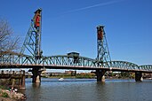
- 2011 – Residents of Portland, Oregon, held a rally called Hands Across Hawthorne in response to an attack against a gay couple holding hands while crossing the Hawthorne Bridge (pictured).
- Benedetto Pistrucci (b. 1783)
- G. K. Chesterton (b. 1874)
- Hubert Opperman (b. 1904)
- Uroš Drenović (d. 1944)
Lake Estancia was a prehistoric body of water in the Estancia Valley, in the center of the U.S. state of New Mexico. Mostly fed by creek and groundwater from the Manzano Mountains, the lake had diverse fauna, including cutthroat trout. It appears to have formed when a river system broke up. It reached a maximum water level (highstand) presumably during the Illinoian glaciation and subsequently fluctuated between a desiccated basin and fuller stages. Wind-driven erosion has excavated depressions in the former lakebed that are in part filled with playas (dry lake beds). The lake was one of several pluvial lakes in southwestern North America that developed during the late Pleistocene. Their formation has been variously attributed to decreased temperatures during the ice age and increased precipitation; a shutdown of the thermohaline circulation and the Laurentide Ice Sheet altered atmospheric circulation patterns and increased precipitation in the region. The lake has yielded a good paleoclimatic record. This map shows the shoreline of Lake Estancia at three different periods: early Estancia (1,939 m / 6,362 ft above sea level), late Estancia (1,897 m / 6,224 ft), and "Lake Willard" (1,870 m / 6,135 ft). Present-day populated places, county boundaries and roads are overlaid on the map for identification.Map credit: Tom Fish


