
Strypa
| Strypa | |
|---|---|
 | |
| Location | |
| Country | Ukraine |
| Physical characteristics | |
| Mouth | Dniester |
• coordinates | 48°52′04″N 25°25′32″E / 48.8679°N 25.4256°E |
| Length | 147 km (91 mi) |
| Basin size | 1,610 km2 (620 sq mi) |
| Basin features | |
| Progression | Dniester→ Dniester Estuary→ Black Sea |
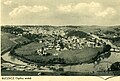
The Strypa (Ukrainian: Стрипа; Hungarian: Sztripa) is a river in Ternopil Oblast, Western Ukraine. It is a left-bank tributary of the Dniester that flows southward for 147 km through Ternopil oblast and drains a basin area of 1,610 km2 (12% territory of Ternopil Oblast). The river is generally approximately 30 m wide and has a sharply defined valley. Its waters are used for industry and agriculture. A small water reservoir has been built on it. The major centers located along the river include Zboriv, Buchach, and Zarvanytsia.
Its main tributaries are Western Strypa, Vosushka, Vil'khovets', and Studenka.
-

-

-
 Meandre in Buchach
 -

-


Sources[edit]
- (in Ukrainian) В. Паращій, Й. Свинко, Стрипа // Ternopil Encyclopedic Dictionary: in 4 v. / editorial board: H. Yavorskyi and other, Ternopil: "Zbruch", 2008, V. 3: П—Я, S. 362. — ISBN 978-966-528-279-2.