Strood (1st) railway station
Strood | |
|---|---|
| General information | |
| Location | Strood, Borough of Medway England |
| Other information | |
| Status | Disused |
| History | |
| Original company | Gravesend and Rochester Railway[1] South Eastern Railway |
| Key dates | |
| 8 February 1845 | Opened as Rochester[1] |
| 13 December 1846 | Closed |
| 23 August 1847 | Reopened |
| July 1849 | Renamed Strood, Rochester and Chatham |
| June 1852 | Renamed Strood |
| 18 Jun 1856 | Closed |
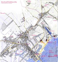
Strood (1st) (locally known as and marked on old maps as The Old Terminus) was a terminus of the South Eastern Railway located in Strood and serving also the towns of Chatham and Rochester. It closed for passengers in 1856 when the present Strood station was opened. The site was then used as a sidings yard until around 1990. It is now occupied by housing development and industrial units.
Former Services
| Preceding station | Disused railways | Following station | ||
|---|---|---|---|---|
| Higham | South Eastern Railway | Terminus |
Maps[edit]


Medway Towns | ||||||||||||||||||||||||||||||||||||||||||||||||||||||||||||||||||||||||||||||||||||||||||||||||||||||||||||||||||||||||||||||||||||||||||||||||||||||||||
|---|---|---|---|---|---|---|---|---|---|---|---|---|---|---|---|---|---|---|---|---|---|---|---|---|---|---|---|---|---|---|---|---|---|---|---|---|---|---|---|---|---|---|---|---|---|---|---|---|---|---|---|---|---|---|---|---|---|---|---|---|---|---|---|---|---|---|---|---|---|---|---|---|---|---|---|---|---|---|---|---|---|---|---|---|---|---|---|---|---|---|---|---|---|---|---|---|---|---|---|---|---|---|---|---|---|---|---|---|---|---|---|---|---|---|---|---|---|---|---|---|---|---|---|---|---|---|---|---|---|---|---|---|---|---|---|---|---|---|---|---|---|---|---|---|---|---|---|---|---|---|---|---|---|---|
| ||||||||||||||||||||||||||||||||||||||||||||||||||||||||||||||||||||||||||||||||||||||||||||||||||||||||||||||||||||||||||||||||||||||||||||||||||||||||||
References[edit]
- ^ a b Butt, R. V. J. (October 1995). The Directory of Railway Stations: details every public and private passenger station, halt, platform and stopping place, past and present (1st ed.). Sparkford: Patrick Stephens Ltd. pp. 198, 223. ISBN 978-1-85260-508-7. OCLC 60251199. OL 11956311M.
51°23′47″N 0°30′08″E / 51.3965°N 0.5021°E
