Romans-sur-Isère
Romans-sur-Isère | |
|---|---|
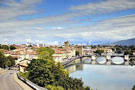
 A view of Romans-sur-Isère and the river Isère | |
| Coordinates: 45°02′47″N 5°03′06″E / 45.0464°N 5.0517°E | |
| Country | France |
| Region | Auvergne-Rhône-Alpes |
| Department | Drôme |
| Arrondissement | Valence |
| Canton | Romans-sur-Isère and Bourg-de-Péage |
| Intercommunality | CA Valence Romans Agglo |
| Government | |
| • Mayor (2020–2026) | Marie-Hélène Thoraval[1] |
| Area 1 | 33.08 km2 (12.77 sq mi) |
| Population (2021)[2] | 32,911 |
| • Density | 990/km2 (2,600/sq mi) |
| Time zone | UTC+01:00 (CET) |
| • Summer (DST) | UTC+02:00 (CEST) |
| INSEE/Postal code | 26281 /26100 |
| Elevation | 122–291 m (400–955 ft) (avg. 167 m or 548 ft) |
| 1 French Land Register data, which excludes lakes, ponds, glaciers > 1 km2 (0.386 sq mi or 247 acres) and river estuaries. | |
Romans-sur-Isère (French pronunciation: [ʁɔmɑ̃ syʁizɛːʁ]; Occitan: Rumans d'Isèra;[3] Old Occitan: Romans) is a commune in the Drôme department in southeastern France.
Geography[edit]
Romans-sur-Isère is located on the Isère, 20 km (12 mi) northeast of Valence. There are more than 50,000 inhabitants in the urban area (if the neighboring town of Bourg-de-Péage is included). Romans is close to the Vercors.
Population[edit]
|
| ||||||||||||||||||||||||||||||||||||||||||||||||||||||||||||||||||||||||||||||||||||||||||||||||||||||||||||||||||
| |||||||||||||||||||||||||||||||||||||||||||||||||||||||||||||||||||||||||||||||||||||||||||||||||||||||||||||||||||
| Source: EHESS[4] and INSEE (1968-2017)[5] | |||||||||||||||||||||||||||||||||||||||||||||||||||||||||||||||||||||||||||||||||||||||||||||||||||||||||||||||||||
Economy[edit]
- Nuclear fuel manufacture (FBFC, Franco-Belge de Fabrication du Combustible), Framatome subsidiary.
- Shoe manufacture (including Robert Clergerie)
History[edit]
- Historian Emmanuel Le Roy Ladurie wrote Carnaval de Romans (1980) a microhistorical study, based on the only two surviving eyewitness accounts, of the 1580 massacre of about twenty artisans at the annual carnival in the town. He treats the massacre as a microcosm of the political, social and religious conflicts of rural society in the latter half of the 16th century in France.
- On 18 July 2017, the town was the end point for Stage Sixteen of the Tour De France.
- On 4 April 2020, two people were killed and five wounded in a knife attack, in what the interior minister called a terrorist incident. Prosecutors said the suspect was a Sudanese refugee in his 30s who lived in the town.[6]
Sights[edit]
- Collegiate Church of Saint-Barnard
- International Museum of Footwear
- Tower of Jacquemart clock

Twin towns - sister cities[edit]
Romans-sur-Isère is twinned with:[7]
Notable people[edit]
- Hippolyte Charles (1773-1837), lover of Joséphine Bonaparte
- Robert Clergerie, shoe designer
- Érik Comas (1963-), former Formula One driver
- Pierre Latour (1993-), cyclist
- Jules Nadi (1872-1928), former mayor and councilor who did much to develop the city
- Baptiste Reynet, professional footballer
- Philippe Saint-André, rugby player and national team coach
- Thomas Arthur, Comte de Lally, general of Irish Jacobite ancestry
See also[edit]
References[edit]
- ^ "Répertoire national des élus: les maires". data.gouv.fr, Plateforme ouverte des données publiques françaises (in French). 2 December 2020.
- ^ "Populations légales 2021". The National Institute of Statistics and Economic Studies. 28 December 2023.
- ^ Bouvier, Jean-Claude (1976) Les parlers provençaux de la Drôme. Étude de géographie phonétique, coll. Bibliothèque française et romane A-33, Paris: Klincksieck, pp. 445-518
- ^ Des villages de Cassini aux communes d'aujourd'hui: Commune data sheet Romans-sur-Isère, EHESS (in French).
- ^ Population en historique depuis 1968, INSEE
- ^ "France launches terror probe after knife attack". BBC News. 5 April 2020. Retrieved 5 April 2020.
- ^ "Relations internationales". ville-romans.fr (in French). Romans-sur-Isère. Retrieved 20 November 2019.
External links[edit]
Wikimedia Commons has media related to Romans-sur-Isère.
- Town council website (in French)
- Communauté de communes du Pays de Romans website
- New Uranium Leak Found in French Areva Factory
- . Encyclopædia Britannica (11th ed.). 1911.


