
Pelleport
Pelleport | |
|---|---|
.jpg) The church and surroundings in Pelleport | |
 Coat of arms | |
Location of Pelleport  | |
 Pelleport  Pelleport | |
| Coordinates: 43°44′22″N 1°07′03″E / 43.7394°N 1.1175°E | |
| Country | France |
| Region | Occitania |
| Department | Haute-Garonne |
| Arrondissement | Toulouse |
| Canton | Léguevin |
| Intercommunality | Hauts Tolosans |
| Government | |
| • Mayor (2020–2026) | Serge Bagur[1] |
| Area 1 | 10.38 km2 (4.01 sq mi) |
| Population (2021)[2] | 531 |
| • Density | 51/km2 (130/sq mi) |
| Time zone | UTC+01:00 (CET) |
| • Summer (DST) | UTC+02:00 (CEST) |
| INSEE/Postal code | 31413 /31480 |
| Elevation | 157–275 m (515–902 ft) (avg. 270 m or 890 ft) |
| 1 French Land Register data, which excludes lakes, ponds, glaciers > 1 km2 (0.386 sq mi or 247 acres) and river estuaries. | |
Pelleport (French pronunciation: [pɛlpɔʁ]; Occitan: Pelapòrc) is a commune in the Haute-Garonne department in southwestern France.
Monuments[edit]
-
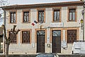 The town hall.
 -
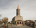 The church.
 -
 The War Memorial.
_La_Mairie.jpg)
_Eglise.jpg)
_Le_monument_aux_Morts.jpg)
Population[edit]
| Year | Pop. | ±% |
|---|---|---|
| 1962 | 162 | — |
| 1968 | 176 | +8.6% |
| 1975 | 163 | −7.4% |
| 1982 | 221 | +35.6% |
| 1990 | 310 | +40.3% |
| 1999 | 344 | +11.0% |
| 2008 | 495 | +43.9% |
See also[edit]
References[edit]
- ^ "Répertoire national des élus: les maires" (in French). data.gouv.fr, Plateforme ouverte des données publiques françaises. 13 September 2022.
- ^ "Populations légales 2021". The National Institute of Statistics and Economic Studies. 28 December 2023.
Wikimedia Commons has media related to Pelleport (Haute-Garonne).
| Authority control databases: National |
|---|
This Haute-Garonne geographical article is a stub. You can help Wikipedia by expanding it. |