
Montafon

Montafon (German: [mɔntaˈfoːn] ⓘ in local dialect: "Muntafu") is a 39 km long valley in the westernmost Austrian federal state of Vorarlberg.[1]
It is traversed by the river Ill (Vorarlberg) and extends from the city of Bludenz and the Verwall Alps in the north, to the Silvretta and Rätikon mountain range in the south. Piz Buin, at 3,312 meters, is the highest peak within the Silvretta mountain range and the highest peak in Vorarlberg. The Montafon region has a population of 16,421(2021).[2]
Geography[edit]

The Montafon is an association of ten communities ("Stand Montafon"),[3] all of which belong to the Bludenz district. The main town is Schruns. Regional tourism is marketed by the Tourist Association Montafon, run by the municipalities, the Vorarlberger Illwerke and the regional mountain cableways.[4]
The municipalities:
- Bartholomäberg (1,100 m)
- Gaschurn (1,000m)
- Lorüns (583 m)
- St. Anton im Montafon (650 m)
- Sankt Gallenkirch (900m)
- Schruns (700 m)
- Silbertal (890 m)
- Stallehr (600 m)
- Tschagguns (700 m)
- Vandans (660 m)
The route from Bludenz into the valley: The state road B188 leads past an old cement plant and through the town of Lorüns. Then one drives through the Alma woods and past the Tränabächle (Brook of Tears). The valley unfolds its full splendor beginning at St. Anton (in the local dialect: "Santatöni") on the left, with Vens and Vandans on the right. St. Anton should not be confused with the more well-known ski resort of St. Anton am Arlberg.
Passing on to Rodund the main electrohydric plant of the Vorarlberger Illwerke comes into view. Continue on through Gantschier and Kaltenbrunnen to Schruns and Tschagguns (in the local dialect: "Schru und Tschaggu"). Above Schruns is the mountain town of Bartholomäberg, with its outlying areas Jetzmunt and Lutt overlooking St. Anton, and its southeastern precincts Kristberg and Innerberg overlooking the Silbertal Valley. This valley stretches southeast from Schruns towards the Arlberg mountain range, passing the outpost of the Fellamendli. The hamlet of Latschau, with its hydroelectric power station and the main base of the Golm ski resort, projecting up over Tschagguns, and opposite Bartholomäberg.
From Schruns and Tschagguns form the midpoint of the Montafon; this divides the outer valley ("Außerfratte") from the inner valley ("Innerfratte"). Continuing up to St. Gallenkirch, the road branches off at Galgenul towards Gargellen, another rugged branch valley that ends at the ski resort of Gargellen. Continuing up the main Montafon valley, the road passes through Gortipohl and on to Gaschurn (in the local dialect: "Gaschorra"), then to Partenen. Here the road snakes up to the Silvretta mountain pass.

Economy[edit]
The economy in the Montafon is dominated by a mixture of traditional rural activities like forestry, hydroelectric energy production, agricultural products, as well as tourism-related services and products.

Agriculture and Farming[edit]
Farming and agriculture are part of traditional Alpine transhumance. This is a three-phase seasonal droving of grazing livestock between the valleys in winter and the high mountain pastures in summer, ensuring a sufficient food supply for the cattle throughout the year.[5] While tourism and other industries contribute more to the economy, seasonal migration to high pastures is still an important economic factor for parts of the population. In the autumn, if no animals have died and there have not been any accidents up in the mountains, the farmers decorate the cattle and bring them down from the mountain pastures in a festive parade, a highlight of regional culture.[6]
Tourism[edit]
Sports[edit]
.jpg)
Tourism plays a vital role and the Montafon is well-known for its skiing, hiking, and mountain biking. The Silvretta high alpine road (German: Hochalpenstraße) gives access to remote ski areas that are located altitudes of 650 to 1,430 meters. The construction of the Montafon Railway in 1905 also helped develop the seasonal tourist industries.[7]
There are five ski regions: Silvretta Montafon, Golm, Gargellen, Silbertal-Kristberg and Silvretta-Bielerhöhe, with a total of 60 ski lifts and 225 kilometers of ski slopes in the region. Freeriding is a popular sport and there are various fun parks with half-pipes. For cross-country skiing there are 121 kilometers of classic routes, as well as 33 kilometers of skating-routes.
Ski mountaineering has become more and more popular and can be pursued on every mountain in the Montafon.[8]
During the summers and autumns the vast hiking trails along all of the mountain ranges are very popular, among locals and tourists alike. There are even trails that can be accessed via pushchairs ("Muntafuner Gagla Weg“). Nine of the ski lifts are also open during the summer and autumn seasons and allow for quick and convenient ascents or descents in the mountains. All hiking and biking trails are well-marked. Many areas are protected and biking is not always allowed. 26 alpine huts are open during the summer, and special buses for hikers operate in the area.
Mountain hiking and climbing are possible on a great variety of trails, with a broad range of difficulties. For beginners, there are eight climbing parks and 15 fixed rope routes.
There are also two 9-hole golf courses in Tschagguns and in Partenen.[9]

Annual events[edit]
Montafoner Resonanzen is a music festival consisting of a series of events in the Montafon region. It is held annually on weekends in August and September. Each weekend is dedicated to another genre (classical, jazz, Austrian folk musik, organ, cross-over). The locations vary each year. Guests may combine hiking and eating out with the concerts, considering the musical performances are held at extraordinary locations like the Tübinger Hütte at 2,191 m (Gaschurn) or the Panoramagasthof Kristberg.[10][11]
Sports[edit]
In the 2012/13 season, the first SBX World Cup Montafon was held as part of the FIS Snowboard World Cup. The World Cup takes place annually in December, with races carried out in the Silvretta Montafon ski area, starting below the Hochjoch summit and finishing near the cable car's mountain station. The difference in altitude between start and finish is around 200 meters. During the World Cup, visitors can watch the snowboarders and skiers during the day time and enjoy concerts in Schruns in the nighttime.[12][13]
The Montafon-Arlberg Marathon is a mountain marathon taking place since 2003. It encomprises 42,195 meters and 1,500 meters in altitude in two federal states (Vorarlberg and Tyrol).[14][15]
Culture[edit]
Customs and Traditions[edit]
Alpine Transhumance plays a vital role in traditional Alpine culture, just as do Yodeling, Alphorn, Schwingen, and cheese production.
Tracht[edit]
The Montafon festive costume for women consists of a black dress (Juppa), whose bodice (Miadr) is laced at the front. An apron (Schoß) in pastel colors is tied over it. The embroidery is particularly valuable on this costume: the "Brosttuach" is tied in the front of the bodice (ibresa), the apron straps (Schoßbänder) are tied over the apron. Nowadays, the "Libli" (actually part of the younger girls' costume) is mainly worn by dance groups instead of outerwear. In this case, a white blouse is also part of the costume. The picture is rounded off by a red petticoat, red stockings, shoes with buckles and a bow tied around the neck.[16]
The most striking feature of the Montafon festive costume is the embroidery. This consists of two or more parts, depending on the occasion and the outer clothing of the costume. All embroidery is handmade, embroidered with silk on black velvet. A skilled embroiderer needs around 500 working hours to produce a complete embroidery.[17]
Today, the traditional garment is still being manufactured at the Juppenwerkstatt Riefensberg.[18]
Outer wear[edit]
- Glöggli-Tschopa: The curly cut Glögglitschopa, so named after the red or green lined frill on the back, has long, narrow sleeves with lapels made of embroidered silk atlas. A characteristic of a well-fitting Glögglitschopa is the Benkli, a fold running from the middle of the breast cloth to the Glöggli.
- Schlutta: The Schlutta, originally the warden chopa, is a brocade jacket. The collar has a delicate white tip.[16]
Headpieces[edit]
- Pelzkappa: a heavy otter skin hat
- Mäßli: a headgear with the shape of a cylinder that widens upwards without a brim
- Sanderhut: The sander hat is a headgear introduced around 1900 for the Montafon costume.
- Schäppel: a silver or gold crown worn by young girls[16]
- Montafoner Tracht
-
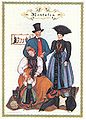 "Trachtenbild 1 des Montafones" by Lisl Thurnher-Weiß (1957)
 -
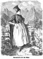
 "Mädchen aus Montafon" (Maiden from Vorarlberg) in Vorarlberg, around 1880
 -
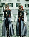 Montafoner Tracht (Schruns)
 -
 "Die Gartenlaube" (1865)
 -
 Montafon woman in wintertracht


_b_652.jpg)


Architecture[edit]
The Montafonerhaus is a house type in the Montafon valley from the 15th to the 20th century. It is a striking feature of the Montafon cultural landscape and is a characteristic of the valley.[19] The classic Montafoner house mixes stone and wood elements.[20]
Cuisine[edit]

The Montafoner Sauerkäse or Montafon cheese (dialect: Sura Kees or Sura Käs, referring to a type of sour cream/curdled milk cheese) is a sour cream cheese made in the Montafon since the 12th century. Montafon has one of the oldest traditions of cheese production in the Alpine region, and this is still an important dairy product. It has very little fat (1-10% fat in dry matter) and is a local speciality, similar to the Tyrolean grey cheese.[21][22]
Gauertaler Alpkultur[edit]
The LEADER programme Gauertaler Alpkultur[23] was created to inform guests and locals in the Gauertal valley about the cultural landscape. Knowledge of this cultural landscape is slowly being lost. Therefore, this path was created to present the Gauertal as a good example of local alpine culture and alpine transhumances. As the trails in the Gauertal are quite popular, the hikers had to be routed in such a way that the sensitive alpine areas were no longer seriously affected. At 13 stations, objects were created by artists who devoted themselves to various cultural areas. Panels and info-brochures tell the stories about the land, the people and the culture.
The following artistic interventions have been created in the Gauertaler landscape:
- Entrance gate
- Tree of Myths (alpine myths)
- Note 1: water & alpine pastures
- Watcher (shepherd's life)
- Alpine regions & tourism (no sculpture)
- Note 2 (forest challenges)
- Tribune (life in the Maisäß)
- Cloakroom (changes of culture)
- Avalanche tree (natural hazards)
- Battlefield (history in the Alps)
- Alpinism (no sculpture)
- Cheese harp (life and work)
- Antler tree (alp and hunting)
There are three different paths and each tells a different story:[24]
- Main tour: Gauertaler Alpkultur: Grüneck (1,890 meters) - Obere Latschätzalpe - Obere Sporaalpe - Lindauer Hütte - untere Sporaalpe - untere Latschätzalpe - Wachters Dieja - Plazadels - Matschwitz. Length: 12.7 km; duration: approx. four ours
- Alptour: Grüneck (1,890 meters) - Obere Latschätzalpe - Obere Sporaalpe - Lindauer Hütte - untere Sporaalpe - untere Latschätzalpe - Gauen - Latschau. Length: 11,3 km; duration: approx. 3.5 hours
- Maisäßtour (tour of alpine transhumance): Grüneck (1,890 meters) - Obere Latschätzalpe - Wachters Dieja - Plazadels - Matschwitz. Length: 6,7 km; duration: approx 2.5 hours

Museums[edit]
In the Montafon valley, there are four museums:[25]
- Heimatmuseum Schruns (Schruns Museum of Local History)
- Alpin- und Tourismusmuseum Gaschurn (Gaschurn Alpine and Tourism Museum)
- Bergbaumuseum Silbertal (Mining Museum Silbertal)
- Museum Frühmesshaus Bartholomäberg
Trivia[edit]
A number of celebrities including Alfred Dassler have stayed in the Montafon valley. Some of the older folks still talk about the long nights in Schruns playing cards and drinking with Ernest Hemingway and John dos Passos. The Snows of the Kilimanjaro (1936) and several other novels and short stories were written in, or they contain material about, the Montafon and the Silvretta glaciers. The famous German novelist and poet Erich Kästner also repeatedly visited the valley, as did the former German chancellor Helmut Kohl. The noted opera singer Elisabeth Schwarzkopf spent her last years in Schruns, where she died on August 2, 2006.
See also[edit]
External links[edit]
- Official website of the Montafon region
- Official website of the Stand Montafon (Association of the ten Montafon communities in the south of Vorarlberg) (in German)
Photo gallery[edit]
-
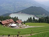
 View into the valley
 -
 View into the valley
 -
 View into the valley
 -
 Montafon-Arlberg marathon (2005)
 -
 Schruns in the Montafon valley
 -
 Jausenstation Bitschweil (small eatery) in Tschagguns


.jpeg)

References[edit]
- ^ "Bergdörfer: Orte im Montafon | Ausflugsziele in Vorarlberg". www.montafon.at (in German). Retrieved 2021-07-11.
- ^ "VORARLBERG - BEVÖLKERUNGSSTAND IM MÄRZ 2021" (PDF). Verwaltungszählung Vorarlberg 2021.
- ^ "Die Geschichte des Standes Montafon — Stand Montafon". stand-montafon.at. Retrieved 2017-01-02.
- ^ "Impressum: Montafon Tourismus GmbH". www.montafon.at. Retrieved 2017-01-02.
- ^ "Österreichische UNESCO-Kommission - Nationalagentur für das Immaterielle Kulturerbe". unesco.scharf.net. Retrieved 2017-01-02.
- ^ www.webdesignsteyr.at, Web-& Mediendesign aus Steyr www ebgrafix at (2020-06-30). "Montafon". planetREISEN - der Reiseclub für Grün-Bewegte! (in Austrian German). Retrieved 2021-07-11.
- ^ "State of Vorarlberg - Tourismus facts and figures". www.vorarlberg.at. Retrieved 2017-01-02.
- ^ "Skitouren Vorarlberg : Wintersport im Montafon, Alpen". www.montafon.at. Retrieved 2017-01-02.
- ^ "Activities in the Montafon - Montafon Austria". www.montafon.at. Retrieved 2017-01-02.
- ^ "Montafoner Resonanzen 2021". www.montafon.at (in German). Retrieved 2021-05-24.
- ^ "kultur-online - Jazz auf der Schutzhütte". kultur-online (in German). 2018-08-10. Retrieved 2021-05-24.
- ^ "Weltcup Montafon im Dezember 2019". www.montafon.at (in German). Retrieved 2019-03-24.
- ^ "Weltcup in Montafon – The world's top-ranking ski- and snowboard-crossathletes". Urlaub in Vorarlberg. 2018-09-17. Retrieved 2019-03-24.
- ^ "Montafon Arlberg Marathon 2021 - Der Berglauf in Vorarlberg und Tirol!". www.montafon.at (in German). Retrieved 2021-07-11.
- ^ Arlberg, Tourismusverband St Anton am. "Montafon Arlberg Marathon". www.stantonamarlberg.com (in German). Retrieved 2021-07-11.
- ^ a b c "Vorarlberger Landestrachtenverband: Festtagstracht". www.trachtenverband.at. Retrieved 2021-07-11.
- ^ Michaela (2020-01-08). "Montafoner Tracht". Silberberg GmbH Montafon (in German). Retrieved 2021-07-11.
- ^ "[SCHAU-]Werkstatt & Verkauf – Juppenwerkstatt Riefensberg" (in German). Retrieved 2021-07-11.
- ^ Josef., Zurkirchen (1988-01-01). Heimatbuch St. Gallenkirch, Gortipohl, Gargellen. Gemeinde St. Gallenkirch. ISBN 3854301014. OCLC 74955669.
- ^ "Architektur in Vorarlberg". DAYOFF.TRAVEL (in German). Retrieved 2021-07-11.
- ^ "Montafoner Sura Kees". www.genuss-region.at. Retrieved 2017-01-02.
- ^ "Montafoner Maisäß - Teil 1". Das Wanderdörfer Hüttenportal (in German). 2014-04-08. Retrieved 2021-07-11.
- ^ Vorarlberg, Kunstforum Montafon. "AlpkulTour Kunstforum Montafon Vorarlberg Österreich". www.kfm.at. Retrieved 2017-02-24.
- ^ Betriebsges.m.b.H., Illwerke Seilbahn. "Gauertaler AlpkulTour - on the culture trail". Golm im Montafon. Retrieved 2017-02-24.
- ^ "Montafoner Museen — Stand Montafon". stand-montafon.at. Retrieved 2021-07-24.
| International | |
|---|---|
| National | |
| Other | |