
Lake-effect snow
| Part of a series on |
| Weather |
|---|
|
|

Lake-effect snow is produced during cooler atmospheric conditions when a cold air mass moves across long expanses of warmer lake water. The lower layer of air, heated by the lake water, picks up water vapor from the lake and rises through colder air. The vapor then freezes and is deposited on the leeward (downwind) shores.[1]
The same effect also occurs over bodies of saline water, when it is termed ocean-effect or bay-effect snow. The effect is enhanced when the moving air mass is uplifted by the orographic influence of higher elevations on the downwind shores. This uplifting can produce narrow but very intense bands of precipitation, which deposit at a rate of many inches of snow each hour, often resulting in a large amount of total snowfall.
The areas affected by lake-effect and parallel "ocean-effect" phenomena are called snowbelts. These include areas east of the Great Lakes in North America, the west coasts of northern Japan, Lake Baikal in Russia, and areas near the Great Salt Lake, Black Sea, Caspian Sea, Baltic Sea, Adriatic Sea, the North Sea and more.
Lake-effect blizzards are the blizzard-like conditions resulting from lake-effect snow. Under certain conditions, strong winds can accompany lake-effect snows creating blizzard-like conditions; however, the duration of the event is often slightly less than that required for a blizzard warning in both the U.S. and Canada.[2]
If the air temperature is low enough to keep the precipitation frozen, it falls as lake-effect snow. If not, then it falls as lake-effect rain. For lake-effect rain or snow to form, the air moving across the lake must be significantly cooler than the surface air (which is likely to be near the temperature of the water surface). Specifically, the air temperature at an altitude where the air pressure is 850 millibars (85 kPa) (roughly 1.5 kilometers or 5,000 feet vertically) should be 13 °C (23 °F) lower than the temperature of the air at the surface. Lake-effect occurring when the air at 850 millibars (85 kPa) is much colder than the water surface can produce thundersnow, snow showers accompanied by lightning and thunder (caused by larger amounts of energy available from the increased instability).
Formation[edit]

Some key elements are required to form lake-effect precipitation and which determine its characteristics: instability, fetch, wind shear, upstream moisture, upwind lakes, synoptic (large)-scale forcing, orography/topography, and snow or ice cover.
Instability[edit]
A temperature difference of approximately 13 °C (23 °F) between the lake temperature and the height in the atmosphere (about 1,500 m or 5,000 ft at which barometric pressure measures 850 mbar or 85 kPa) provides for absolute instability and allows vigorous heat and moisture transportation vertically. Atmospheric lapse rate and convective depth are directly affected by both the mesoscale lake environment and the synoptic environment; a deeper convective depth with increasingly steep lapse rates and a suitable moisture level allow for thicker, taller lake-effect precipitation clouds and naturally a much greater precipitation rate.[3]
Fetch[edit]
The distance that an air mass travels over a body of water is called fetch. Because most lakes are irregular in shape, different angular degrees of travel yield different distances; typically, a fetch of at least 100 km (60 mi) is required to produce lake-effect precipitation. Generally, the larger the fetch, the more precipitation produced. Larger fetches provide the boundary layer with more time to become saturated with water vapor and for heat energy to move from the water to the air. As the air mass reaches the other side of the lake, the engine of rising and cooling water vapor pans itself out in the form of condensation and falls as snow, usually within 40 km (25 mi) of the lake, but sometimes up to about 150 km (100 mi).[4]
Wind shear[edit]
Directional shear is one of the most important factors governing the development of squalls; environments with weak directional shear typically produce more intense squalls than those with higher shear levels. If directional shear between the surface and the height in the atmosphere at which the barometric pressure measures 700 mb (70 kPa) is greater than 60°, nothing more than flurries can be expected. If the directional shear between the body of water and the vertical height at which the pressure measures 700 mb (70 kPa) is between 30° and 60°, weak lake-effect bands are possible. In environments where the shear is less than 30°, strong, well organized bands can be expected.[5]
Speed shear is less critical but should be relatively uniform. The wind-speed difference between the surface and vertical height at which the pressure reads 700 mb (70 kPa) should be no greater than 40 knots (74 km/h) so as to prevent the upper portions of the band from shearing off. However, assuming the surface to 700 mb (70 kPa) winds are uniform, a faster overall velocity works to transport moisture more quickly from the water, and the band then travels much farther inland.[5]

Upstream moisture[edit]
A lower upstream relative humidity lake effect makes condensation, clouds, and precipitation more difficult to form. The opposite is true if the upstream moisture has a high relative humidity, allowing lake-effect condensation, cloud, and precipitation to form more readily and in a greater quantity.[6]
Upwind lakes[edit]
Any large body of water upwind impacts lake-effect precipitation to the lee of a downwind lake by adding moisture or pre-existing lake-effect bands, which can reintensify over the downwind lake. Upwind lakes do not always lead to an increase of precipitation downwind.[7]
Synoptic forcing[edit]
Vorticity advection aloft and large upscale ascent help increase mixing and the convective depth, while cold air advection lowers the temperature and increases instability.[8]
Orography and topography[edit]
Typically, lake-effect precipitation increases with elevation to the lee of the lake as topographic forcing squeezes out precipitation and dries out the squall much faster.[9]
Snow and ice cover[edit]
As a lake gradually freezes over, its ability to produce lake-effect precipitation decreases for two reasons. Firstly, the open ice-free liquid surface area of the lake shrinks. This reduces fetch distances. Secondly, the water temperature nears freezing, reducing overall latent heat energy available to produce squalls. To end the production of lake-effect precipitation, a complete freeze is often not necessary.[10]
Even when precipitation is not produced, cold air passing over warmer water may produce cloud cover. Fast-moving mid-latitude cyclones, known as Alberta clippers, often cross the Great Lakes. After the passage of a cold front, winds tend to switch to the northwest, and a frequent pattern is for a long-lasting low-pressure area to form over the Canadian Maritimes, which may pull cold northwestern air across the Great Lakes for a week or more, commonly identified with the negative phase of the North Atlantic Oscillation (NAO). Since the prevailing winter winds tend to be colder than the water for much of the winter, the southeastern shores of the lakes are almost constantly overcast, leading to the use of the term "the Great Gray Funk" as a synonym for winter.[citation needed] These areas allegedly contain populations that suffer from high rates of seasonal affective disorder, a type of psychological depression thought to be caused by lack of light.[11][citation needed]
Examples[edit]
North America[edit]
The Great Lakes region[edit]


Cold winds in the winter typically prevail from the northwest in the Great Lakes region, producing the most dramatic lake-effect snowfalls on the southern and eastern shores of the Great Lakes. This lake effect results in much greater snowfall amounts on the southern and eastern shores compared to the northern and western shores of the Great Lakes.
The most affected areas include the Upper Peninsula of Michigan; Northern New York and Central New York; particularly the Tug Hill Region, Western New York; Northwestern Pennsylvania; Northeastern Ohio; southwestern Ontario and central Ontario; Northeastern Illinois (along the shoreline of Lake Michigan); northwestern and north central Indiana (mostly between Gary and Elkhart); northern Wisconsin (near Lake Superior); and West Michigan.[12]
Lake-effect snows on the Tug Hill plateau (east of Lake Ontario) can frequently set daily records for snowfall in the United States. Tug Hill receives, typically, over 20 feet (240 in; 610 cm) of snow each winter.[13] The snowiest portions of the Tug Hill, near the junction of the towns of Montague, Osceola, Redfield, and Worth, average over 300 inches (760 cm) of snow annually.[14]
From February 3–12, 2007, a lake-effect snow event left 141 inches (358 cm) of snow in 10 days at North Redfield on the Tug Hill Plateau.[15][16] Other examples major prolonged lake effect snowstorms on the Tug Hill include December 27, 2001, - January 1, 2002, when 127 inches (320 cm) of snow fell in six days in Montague, January 10–14, 1997, when 110.5 inches (281 cm) of snow fell in five days in North Redfield, and January 15–22, 1940, when over eight feet of snow fell in eight days at Barnes Corners.[16]
Syracuse, New York, directly south of the Tug Hill Plateau, receives significant lake-effect snow from Lake Ontario, and averages 115.6 inches (294 cm) of snow per year, which is enough snowfall to be considered one of the "snowiest" large cities in America.[17][18]
Lake Erie produces a similar effect for a zone stretching from the eastern suburbs of Cleveland through Erie to Buffalo.[19] Remnants of lake-effect snows from Lake Erie have been observed to reach as far south as Garrett County, Maryland, and as far east as Geneva, New York.[20] Because it is not as deep as the other lakes, Erie warms rapidly in the spring and summer, and is frequently the only Great Lake to freeze over in winter.[21] Once frozen, the resulting ice cover alleviates lake-effect snow downwind of the lake. Based on stable isotope evidence from lake sediment coupled with historical records of increasing lake-effect snow, global warming has been predicted to result in a further increase in lake-effect snow.[22]
A very large snowbelt in the United States exists on the Upper Peninsula of Michigan, near the cities of Houghton, Marquette, and Munising. These areas typically receive 250–300 inches (635–762 cm) of snow each season.[23] For comparison, on the western shore, Duluth, Minnesota receives 78 inches (198 cm) per season.[24]
Western Michigan, western Northern Lower Michigan, and Northern Indiana can get heavy lake-effect snows as winds pass over Lake Michigan and deposit snows over Muskegon, Traverse City, Grand Rapids, Kalamazoo, New Carlisle, South Bend, and Elkhart, but these snows abate significantly before Lansing or Fort Wayne, Indiana. When winds become northerly or aligned between 330 and 390°, a single band of lake-effect snow may form, which extends down the length of Lake Michigan. This long fetch often produces a very intense, yet localized, area of heavy snowfall, affecting cities such as La Porte and Gary.[25]
Lake-effect snow is virtually unheard of in Detroit, Toledo, Milwaukee, Toronto, and Chicago, because the region's dominant winds are from the northwest, making them upwind from their respective Great Lakes, although they, too, have on extremely rare occasion seen small amounts of lake-effect snow during easterly or northeasterly winds. More frequently, the north side of a low-pressure system picks up more moisture over the lake as it travels east, creating a phenomenon called lake-enhanced precipitation.[25] However, a place like Altoona, Pennsylvania or Oakland, Maryland is far more likely to receive lake effect snow than either aforementioned location despite greater distance from the lakes, because of being on the windward side of the lake.
Because Southwestern Ontario is surrounded by water on three sides, many parts of Southwestern and Central Ontario get a large part of their winter snow from lake-effect snow.[26] This region is notorious for the whiteouts that can suddenly reduce highway visibility on North America's busiest highway (Ontario Highway 401)[27] from clear to zero. The region most commonly affected spans from Port Stanley in the west, the Bruce Peninsula in the north, Niagara-on-the-Lake to the east, and Fort Erie to the south. The heaviest accumulations usually happen in the Bruce Peninsula, which is between Lake Huron and Georgian Bay. So long as the Great Lakes are not frozen over, the only time the Bruce Peninsula does not get lake-effect snow is when the wind is directly from the south.
-
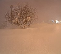
 Buffalo, New York, after 82.3 inches (209 cm) of snow fell from December 24, 2001, to December 28, 2001
 -
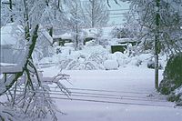
 Fulton, New York, after a snowburst dropped 4–6 feet (122–183 cm) of snow over most of Oswego County January 28–31, 2004
 -
 The Veteran's Day storm of November 9–14, 1996, may be the most severe early-season lake-effect snow storm the Great Lakes has witnessed in the past 50 years. At the height of the storm, over 160,000 customers were without power in Greater Cleveland alone, as the storm produced isolated snowfall tallies approaching 70 inches (178 cm).


Elsewhere in the United States[edit]
The southern and southeastern sides of the Great Salt Lake receive significant lake-effect snow. Since the Great Salt Lake never freezes, the lake effect can influence the weather along the Wasatch Front year-round. The lake effect largely contributes to the 55–80 inches (140–203 cm) annual snowfall amounts recorded south and east of the lake, and in average snowfall reaching 500 inches (13 m) in the Wasatch Range. The snow, which is often very light and dry because of the semiarid climate, is referred to as the "Greatest Snow on Earth" in the mountains. Lake-effect snow contributes to roughly six to eight snowfalls per year in Salt Lake City, with about 10% of the city's precipitation being contributed by the phenomenon.[28]
On one occasion in December 2016, lake-effect snow fell in central Mississippi from a lake band off Ross Barnett Reservoir.[29]
The West Coast occasionally experiences ocean-effect showers, usually in the form of rain at lower elevations south of about the mouth of the Columbia River. These occur whenever an Arctic air mass from western Canada is drawn westward out over the Pacific Ocean, typically by way of the Fraser Valley, returning shoreward around a center of low pressure. Cold air flowing southwest from the Fraser Valley can also pick up moisture over the Strait of Georgia and Strait of Juan de Fuca, then rise over the northeastern slopes of the Olympic Mountains, producing heavy, localized snow between Port Angeles and Sequim, as well as areas in Kitsap County and the Puget Sound region.[30]
While snow of any type is very rare in Florida, the phenomenon of gulf-effect snow has been observed along the northern coast of the Gulf of Mexico a few times in history. More recently, "ocean-effect" snow occurred on January 24, 2003, when wind off the Atlantic, combined with air temperatures in the 30 °F range, brought snow flurries briefly to the Atlantic Coast of northern Florida seen in the air as far south as Cape Canaveral.[31]
Eurasia[edit]
Istanbul and northern Turkey[edit]
Because the southern Black Sea is relatively warm (around 13 °C or 55 °F at the beginning of winter, typically 10 to 6 °C or 50 to 43 °F by the end), sufficiently cold air aloft can create significant snowfalls in a relatively short period of time.[32] Furthermore, cold air, when it arrives to the region, tends to move slowly, creating days and sometimes weeks of occasional lake-effect snowfall.[32]
The most populous city in the region, Istanbul, is very prone to lake-effect snow and this weather phenomenon occurs almost every winter, despite winter averages only being moderately cool at 5 °C (41 °F), comparable to Paris.[33] On multiple occasions, lake-effect snowfall events have lasted for more than a week, and official single-storm snow depth totals have exceeded 80 centimeters (2.6 ft; 31 in) downtown and 104 centimeters (3.41 ft; 41 in) around the city.[34][33][35] Earlier, unofficial measurements are often higher, due to the relative dearth of sufficiently old weather stations in the region; with some sources claiming up to 4 meters (13 ft; 160 in) of snowfall during the blizzard of March 1987.[36]
Meanwhile, snowfall in mountainous provinces in this region is amplified by orographic effect, often resulting in snowfall of several meters, especially at higher elevations.
Around the Baltic Sea[edit]
In Northern Europe, cold, dry air masses from Russia can blow over the Baltic Sea and cause heavy snow squalls on areas of the southern and eastern coasts of Sweden, as well as on the Danish island of Bornholm, the east coast of Jutland and the northern coast of Poland. For the northern parts of the Baltic Sea, this happens mainly in the early winter, since it freezes later. Southeast Norway can also experience heavy sea snow events with east-north-easterly winds. Especially, coastal areas from Kragero to Kristiansand have had incredible snow depths in the past with intense persistent snowbands from Norwegian Sea (the coastal city of Arendal recorded 280 cm (110 in) in a single week in late February 2007).[37] Although Fennoscandia is lined with an abundance of lakes, this type of snowfall is rare in these, due to the shallow freshwater freezing early in the cold interiors. One notable exception happened in the middle of May 2008, as Leksand on the since-long unfrozen lake of Siljan got 30 cm (12 in) on the ground.[38]
East Asia[edit]
The Sea of Japan creates snowfall in the mountainous western Japanese prefectures of Niigata and Nagano, parts of which are known collectively as snow country (Yukiguni). In addition to Japan, much of maritime Korea and the Shandong Peninsula experience these conditions.[39]
Siberia[edit]
Strong winds and a very large, deep lake enhance snowfall around Lake Baikal in the fall; however, nearly the entire surface of the lake freezes from January until Spring, precluding lake-effect snow.[40]
Iran[edit]
Moving of polar or Siberian high-pressure centers along Caspian Sea regarding to relatively warmer water of this sea can make heavy snowfalls in the northern coast of Iran. Several blizzards have been reported in this region during the last decades. In February 2014, heavy snowfall reached 200 cm (79 in) on the coastline in Gilan and Mazandaran provinces of Iran. The heaviest snowfall was reported in Abkenar village near Anzali Lagoon.[41][42][43][44]
-
![IRIMO[45] radar animation of lake effect snow in southern coast of Caspian Sea in the north of Iran](//upload.wikimedia.org/wikipedia/commons/thumb/a/ab/Caspian-lake-effect.gif/200px-Caspian-lake-effect.gif) IRIMO[45] radar animation of lake effect snow in southern coast of Caspian Sea in the north of Iran
IRIMO[45] radar animation of lake effect snow in southern coast of Caspian Sea in the north of Iran -
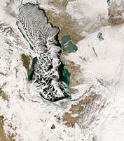 Lake-effect clouds over Caspian Sea on January 7, 2008
![IRIMO[45] radar animation of lake effect snow in southern coast of Caspian Sea in the north of Iran](/wiki/File:Caspian-lake-effect.gif)

United Kingdom[edit]
In the United Kingdom, easterly winds bringing cold continental air across the North Sea can lead to a similar phenomenon. Locally, it is also known as "lake-effect snow" despite the snow coming in from the sea rather than a lake.[46] Similarly during a north-westerly wind, snow showers can form coming in from the Liverpool Bay, coming down the Cheshire gap, causing snowfall in the West Midlands—this formation resulted in the white Christmas of 2004 in the area, and most recently the heavy snowfall of 8 December 2017 and 30 January 2019.[47][48]
The best-known example occurred in January 1987, when record-breaking cold air (associated with an upper low) moved across the North Sea towards the UK. The result was over 2 ft of snow for coastal areas, leading to communities being cut off for over a week. The latest of these events to affect Britain's east coast occurred on November 30, 2017; February 28, 2018; and March 17, 2018; in connection with the 2018 Great Britain and Ireland cold wave.[49] The second event of winter 2017/18 was particularly severe, with up to 27.5 inches (70 cm) falling in total over the 27th–28th.[50]
Similarly, northerly winds blowing across the relatively warm waters of the English Channel during cold spells can bring significant snowfall to the French region of Normandy, where snow drifts exceeding 10 ft (3 m) were measured in March 2013.[51]
-
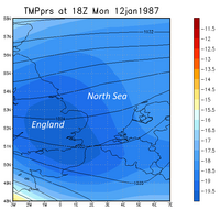 Chart showing the sea-effect snow event of January 1987 in the UK: A continuous stream of showers deposited over 2 feet (24 in) of snow over SE coastal regions.
 -
![NetWeather[52] radar image showing "lake-effect" snow over Kent and northeast England](//upload.wikimedia.org/wikipedia/en/thumb/c/c2/Lakeeffect.png/200px-Lakeeffect.png)

![NetWeather[52] radar image showing "lake-effect" snow over Kent and northeast England](/wiki/File:Lakeeffect.png)
See also[edit]
Warnings about lake-effect snow:
- United States:
References[edit]
- ^ "Warm Water and Cold Air: The Science Behind Lake-Effect Snow". National Oceanic and Atmospheric Administration. Archived from the original on January 2, 2015. Retrieved January 2, 2015.
- ^ "WFO Winter Weather Products Specification" (PDF). National Weather Service. May 7, 2020. Archived (PDF) from the original on August 18, 2006.
- ^ Byrd, Greg (June 3, 1998). "Lake Effect Snow: Instability". University Corporation for Atmospheric Research. Archived from the original on June 17, 2009.
- ^ Byrd, Greg (June 3, 1998). "Lake Effect Snow: Fetch". University Corporation for Atmospheric Research. Archived from the original on May 15, 2008.
- ^ a b Byrd, Greg (June 3, 1998). "Lake Effect Snow: Wind Shear". University Corporation for Atmospheric Research. Archived from the original on May 11, 2008.
- ^ Byrd, Greg (June 3, 1998). "Lake Effect Snow: Upstream Moisture". University Corporation for Atmospheric Research. Archived from the original on May 9, 2008.
- ^ Byrd, Greg (June 3, 1998). "Lake Effect Snow: Upstream Lakes". University Corporation for Atmospheric Research. Archived from the original on May 9, 2008.
- ^ Byrd, Greg (June 3, 1998). "Lake Effect Snow: Synoptic-Scale Forcing". University Corporation for Atmospheric Research. Archived from the original on May 16, 2008.
- ^ Byrd, Greg (June 3, 1998). "Lake Effect Snow: Orography/Topography". University Corporation for Atmospheric Research. Archived from the original on May 9, 2008.
- ^ Byrd, Greg (June 3, 1998). "Lake Effect Snow: Snow/Ice Cover on the Great Lakes". University Corporation for Atmospheric Research. Archived from the original on May 15, 2008.
- ^ "Health Advisories: Weather and Mood". The Weather Underground. Archived from the original on February 21, 2007. Retrieved January 4, 2007.
- ^ "Mean Monthly and Annual Snowfall for the Conterminous United States". The Climate Source. 2003. Archived from the original on June 9, 2008.
- ^ "Tug Hill Plateau – New York". Northern Forest Alliance. Archived from the original on May 9, 2008. Retrieved February 1, 2015.
- ^ "Average Annual Snowfall". National Weather Service Buffalo Forecast Office. Archived from the original on March 7, 2023. Retrieved March 7, 2023.
- ^ "Climate of 2007 – February in Historical Perspective". National Climatic Data Center. March 15, 2007. Archived from the original on December 21, 2007. Retrieved March 1, 2008.
- ^ a b Bassette, Kellen (2023). A History of Severe Weather to the lee of Lake Erie and Lake Ontario in Western, Central, and North-Central New York 1798-2022. Kellen Bassette. pp. 403–407, 603–608, 623–628, 643–649. ISBN 978-1-0880-7520-3.
- ^ Cappella, Chris (October 3, 2003). "Answers: 10 snowiest 'cities' aren't all in New York". USA Today. Archived from the original on October 12, 2011.
- ^ Kirst, Sean (March 14, 2005). "We won't buckle under the Snowbelt's blows". The Post-Standard.
- ^ Schmidlin, Thomas W. (1989). "Climatic Summary of Snowfall and Snow Depth in the Ohio Snowbelt at Chardon" (PDF). The Ohio Journal of Science. 89 (4): 101–108. Archived (PDF) from the original on July 16, 2007. Retrieved March 1, 2008.
- ^ "February Brings Winter Weather to the Northeast". Northeast Regional Climate Center. February 1995. Archived from the original on June 11, 2007. Retrieved March 1, 2008.
- ^ "Introduction to the Great Lakes: Lake Erie". Great Lakes Information Network. Archived from the original on May 9, 2008. Retrieved March 1, 2008.
- ^ Burnett, Adam W.; Kirby, Matthew E.; Mullins, Henry T.; Patterson, William P. (2003). "Increasing Great Lake–Effect Snowfall during the Twentieth Century: A Regional Response to Global Warming?". Journal of Climate. 16 (21): 3535–3542. Bibcode:2003JCli...16.3535B. doi:10.1175/1520-0442(2003)016<3535:IGLSDT>2.0.CO;2. S2CID 58935593.
- ^ Ruhf, Robert J. "Lake-Effect Precipitation in Michigan". Dr. Robert J. Ruhf. Archived from the original on March 12, 2008. Retrieved March 1, 2008.
- ^ "Average Snowfall, Inches". University of Utah, Department of Meteorology. Archived from the original on February 12, 2008. Retrieved March 1, 2008.
- ^ a b "Lake-effect Snow in the Great Lakes Region". Great Lakes Integrated Sciences and Assessments. Archived from the original on April 13, 2014. Retrieved April 10, 2014.
- ^ Scott, Cameron (December 14, 2010). "How Lakes Affect Snowfalls". Sciences360.com. Archived from the original on July 4, 2014. Retrieved October 23, 2013.
- ^ Jennings, Ken (June 18, 2018). "The World's Widest Highway Spans a Whopping 26 Lanes". Condé Nast Traveler. Archived from the original on January 25, 2021. Retrieved February 17, 2021.
- ^ Bauman, Joe (August 5, 1999). "Lake has great impacts on storm, weather". Deseret News. Archived from the original on October 2, 2012.
- ^ Hutton, Brian (December 20, 2016). "Tuesday, December 20 Afternoon Forecast Discussion". WTOK-TV. Archived from the original on January 7, 2017. Retrieved January 7, 2017.
- ^ Mass, Cliff (2008). The Weather of the Pacific Northwest. University of Washington Press. p. 60. ISBN 978-0-295-98847-4.
- ^ "Cold Temperatures and Snow Flurries in East-Central Florida January 24, 2003" (PDF). National Weather Service Office, Melbourne, Florida. Archived (PDF) from the original on January 27, 2017. Retrieved November 5, 2006.
- ^ a b Kindap, Tayfin (January 19, 2010). "A Severe Sea-Effect Snow Episode Over the City of Istanbul". Natural Hazards. 54 (3): 703–23. Bibcode:2010NatHa..54..707K. doi:10.1007/s11069-009-9496-7. ISSN 1573-0840. S2CID 140188530.
- ^ a b "Resmi İstatistikler". mgm.gov.tr. Meteoroloji Genel Müdürlüğü. Archived from the original on December 23, 2020. Retrieved December 13, 2020.
- ^ Arango, Tim (January 11, 2017). "Snow Acts as a Magical Balm in an Anxious Turkey (Published 2017)". The New York Times. Retrieved December 13, 2020.
- ^ Tayanç, Mete; Karaca, Mehmet; Dalfes, H. Nüzhet (1998). "March 1987 Cyclone (Blizzard) over the Eastern Mediterranean and Balkan Region Associated with Blocking". Monthly Weather Review. 126 (11): 3036. Bibcode:1998MWRv..126.3036T. doi:10.1175/1520-0493(1998)126<3036:MCBOTE>2.0.CO;2. hdl:11424/245760.
- ^ "1987 İstanbul kışında neler yaşandı? Tarihe geçen kar fırtınasından çarpıcı fotoğraflar". www.cumhuriyet.com.tr (in Turkish). Retrieved March 2, 2023.
- ^ "Rapport om vær- og føreforhold i Agder i perioden 20.-28. februar 2007" [Report on weather and driving conditions in Agder in the period 20–28 February 2007]. Statens vegvesen [State Highways Authority] (in Norwegian). May 1, 2007. Archived from the original on October 25, 2019. Retrieved October 25, 2019.
- ^ "Maj 2008 - Både sommarvärme och sent snöfall" (in Swedish). Swedish Meteorological and Hydrological Institute. June 2, 2008. Archived from the original on October 3, 2022. Retrieved March 31, 2022.
- ^ Bao, Baoleerqimuge & Ren, Guoyu (May 2018). "Sea-Effect Precipitation over the Shandong Peninsula, Northern China". Journal of Applied Meteorology and Climatology. 57 (6): 1291–1308. Bibcode:2018JApMC..57.1291B. doi:10.1175/JAMC-D-17-0200.1. S2CID 126039299 – via ResearchGate.
- ^ Dolce, Chris; Belles, Jonathan (January 11, 2017). "Surprising Bodies Of Water That Have Spawned Lake-Effect Snow". The Weather Channel. Retrieved October 15, 2023.
- ^ "Snow Blankets Iran". NASA Earth Observatory. February 11, 2014. Archived from the original on October 7, 2021. Retrieved October 7, 2021.
- ^ "Iran snow cuts power to nearly 500,000 homes". BBC News. February 3, 2014. Archived from the original on October 24, 2020. Retrieved June 21, 2018.
- ^ "Heavy Snow Kills Dozens in Asia". National Geographic. January 10, 2008. Archived from the original on July 24, 2008.
- ^ "Iranians use Facebook to save villagers from snowstorm". The Observers. France 24. February 14, 2014. Archived from the original on February 22, 2014. Retrieved February 14, 2014.
- ^ "سازمان هواشناسی :: Weather" (in Persian). Iran Meteorological Organization. Archived from the original on August 29, 2014. Retrieved January 1, 2022.
- ^ "Conversations". uk.sci.weather archives. Archived from the original on January 30, 2018. Retrieved August 3, 2007.
- ^ "Snow closes schools in Greater Manchester plus city airports". BBC News. January 30, 2019. Archived from the original on February 13, 2019. Retrieved February 13, 2019.
- ^ Rowden, Nathan (December 8, 2017). "Heavy snow causes chaos in Shropshire - and there's more on the way". Shropshire Star. Archived from the original on December 9, 2017. Retrieved December 8, 2017.
- ^ "Snow falls on England's east coast beaches". BBC News. November 30, 2017. Archived from the original on March 31, 2018. Retrieved June 21, 2018.
- ^ Hopewell, John (February 28, 2018). "Brutal storm is pummeling Britain with heavy snow and wicked wind chill". The Washington Post. Archived from the original on September 17, 2018. Retrieved August 7, 2018.
- ^ "Neige. Le mois de mars de tous les records en Normandie" [Snow. The month of March of all records in Normandy]. actu.fr (in French). March 14, 2013. Archived from the original on December 3, 2013. Retrieved November 26, 2013.
- ^ "Netweather". netweather.tv. Archived from the original on October 7, 2021. Retrieved October 7, 2021.
External links[edit]
- National Weather Service Official Lake Effect Page—based in Buffalo, NY
- Lake effect forecasting
- Video of a snowsquall timelapse while driving on Highway 407 ETR in Greater Toronto
- Digital Snow Museum
- Ice and snow measurements on lakes and surrounding land areas Archived 2010-05-27 at the Wayback Machine, Great Lakes Environmental Research Laboratory
- A BBC forecast of lake effect snow in the UK in 1991