
Kościuszko Mound

Kościuszko Mound (Polish: kopiec Kościuszki) is an artificial mound in Kraków, Poland. It was erected by Cracovians in commemoration of the Polish national leader Tadeusz Kościuszko, and modelled after Kraków's prehistoric mounds of Krak and Wanda. A serpentine path leads to the top, approximately 326 metres (1,070 ft) above sea level, with a panoramic view of the Vistula River and the city.
History[edit]

It was completed in November 1823.[1] The location selected for the monument was the natural Blessed Bronisława Hill (Polish: Wzgórze bł. Bronisławy), also known as Sikornik, situated in the western part of Kraków's Zwierzyniec District.
Kościuszko Mound is one of Kraków's four memorial mounds, consisting of two prehistoric mounds, Krakus Mound and Wanda Mound, and two modern ones, Piłsudski Mound and Kościuszko Mound.
The founding ceremony of the Kościuszko Mound took place on 16 October 1820. The construction was financed by donations from Poles living in all territories of Poland under foreign occupation. For three years, people of all ages and class voluntarily constructed the mound to the height of 34 metres (112 ft). Work was supervised by a Committee for the Construction of the Tadeusz Kościuszko Monument. At the base of the mound, the Founding Act was deposited in a glass and marble case. At the top, a granite boulder, brought from the Tatra Mountains, was placed, bearing the inscription "Kościuszce" (To Kościuszko). Inside the mound, urns were buried with soil from the Polish and American battlefields where Kościuszko fought. In 1860, on the 30th anniversary of the Polish November Uprising, the top of the mound was crowned with a boulder (545 kg) of granite from Tatra mountains which had engraved upon it: TO KOŚCIUSZKO.
Initially, the grounds around Kościuszko Mound were planned to be turned into a colony settlement for the peasant families that fought alongside Tadeusz Kościuszko in the uprising of 1794. In the late 1830s, those families began to settle at the foothills of Kościuszko Mound, but the process came to a halt when Austrian authorities decided to turn this area into a part of city's fortification.[2]
Between 1850 and 1854, the Austrian authorities built a brick citadel around the mound and began using it as a strategic lookout. As compensation for an earlier historical church that had been demolished, a neo-Gothic chapel of Blessed Bronisława was also built. However, the Austrian fortifications, including the gateway and the southwestern rampart and entrenchment were eventually dismantled following World War II, between 1945 and 1956.
Next to the mound there is a museum devoted to Kościuszko, that displays artefacts and mementoes of his life and achievements. In 1997, heavy rains eroded the mound, thus threatening its existence. It went through a restoration process from 1999 till 2003 in which state-of-the-art technology and modern materials were used. The mound was equipped with a drainage system and a new waterproofing membrane.
Kościuszko Mound inspired Count Paul Strzelecki, Polish patriot and Australian explorer, to name the highest mountain in Australia Mount Kosciuszko, because of its perceived resemblance to the Kościuszko Mound in Kraków.[3]
The mound in numbers[edit]
- Mound height: 35.54m
- Mound height above sea level: 330.14m
- Mound height above Vistula level: 131.14m
- Mound diameter: 73.25m
- Mound diameter with retaining wall (tamboure): 90.7m
- Viewing platform diameter: 8.5m
- Mound volume: approx. 167,000m³
- Slope angle: 46°-51°
Gallery[edit]
-
 Kościuszko Mound, Kraków. Note the visitors in the foreground for scale.
 -
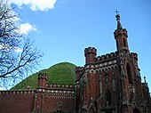 View of Kościuszko Mound, with Bronisława Chapel at its foot
 -
 Kosciuszko's Mound, seen from Kraków Błonia Park,
Polish National Flag Day (2 May 2019) -
 View from the top of Kościuszko Mound


,_B%C5%82onia_Park,_Foch_Av,_Krakow,_Poland.jpg)

See also[edit]
Notes[edit]
- ^ Alex Webber (25 October 2023). "Happy Birthday! Kraków's iconic Kościuszki Mound turns 200". thefirstnews.com. Retrieved 27 October 2023.
- ^ "Mounds of Krakow". Krakow.wiki. 2017-03-24. Retrieved 2019-04-25.
- ^ Mt Kosciuszko. Australian Geographical Name Derivations.[1] Archived 2020-01-02 at the Wayback Machine.
References[edit]
- The mound of Tadeusz Kościuszko at the official website of the city of Kraków
- History of the Kościuszko Mound at Kościuszko Mound Homepage, Kraków
- Repairing of the Kościuszko Mound. An unconventional civil engineering project. Page archived by Internet Archive Wayback Machine
- Lives and Deeds of Foreign-born Heroes of the American Revolution, The United States Commission for the Preservation of America's Heritage Abroad, 107th Congress of the United States of America, 4 July 2002. Pg. 35. (PDF 2.5 MB)
| Authority control databases: National |
|---|