
Kashan
This article includes a list of general references, but it lacks sufficient corresponding inline citations. (June 2009) |
Kashan
کاشان | |
|---|---|
City | |
     Clockwise from the top: Borujerdi House, Sultan Amir Ahmad Bathhouse, Tabatabai House, Agha Bozorg Mosque, Fin Garden. | |
 Kashan Location in Iran | |
| Coordinates: 33°58′57″N 51°25′57″E / 33.98250°N 51.43250°E[1] | |
| Country | Iran |
| Province | Isfahan |
| County | Kashan |
| District | Central |
| Government | |
| • Mayor | Kioumars Mohammadpour |
| Population (2016)[2] | |
| • Urban | 304,487 |
| • Metro | 432,557 |
| Time zone | UTC+3:30 (IRST) |
| Website | www |


Kashan (Persian: کاشان; [kɒːˈʃɒːn] ⓘ), also Romanized as Kâšân and Kāshān;[3] also known as Qashan and Cassan,[4] is a city in the Central District of Kashan County, in the northern part of Isfahan province, Iran, serving as capital of both the county and the district.[5]
At the 2006 National Census, its population was 248,789 in 67,464 households.[6] The following census in 2011 counted 275,325 people in 80,015 households.[7] The latest census in 2016 showed a population of 304,487 people in 91,935 households.[2]
Kashan is divided into two parts, mountainous and desert.
On August 9, 2007, Iran placed the Historical Axis of Fin, Sialk, Kashan on its Tentative List for possible future nomination as a UNESCO World Heritage Site. The exact definition of what locations within Kashan proper might be nominated was not made clear. In 2012 Iran successfully nominated the Fin Garden separately for inscription by UNESCO as a part of its Persian Gardens World Heritage Site. Despite this the "Historical-Cultural Axis of Fin, Sialk, Kashan" remains in full on Iran's Tentative List. The Boroujerdiha house is one of the historical places from the Qajar period.
History[edit]
Earliest evidence of human presence around Kashan date back to Paleolithic period that have been found at Niasar, Kaftar Khoun and Sefid-Ab. Middle Paleolithic stone tools were discovered at travertine spring of Niasar and the travertine of Kaftar Khoun.[8] Upper Paleolithic groups were living around Sefid-Ab spring at SW of Kashan.[9]
By some accounts, although not all, Kashan was the origin of the three wise men who followed the star that guided them to Bethlehem to witness the nativity of Jesus, as recounted in the Bible.[10] For example, medieval traveler Friar Odoric of Pordenone related this story in 1330 after having visited there.[11]
According to a legend dating from the Safavid era, Abu Lu'lu'a, the Persian skilled craftsman who was enslaved by the Islamic conquerors and who eventually assassinated the caliph Umar ibn al-Khattab in 644, fled to Kashan after the assassination.[12] The shrine that was built over his supposed tomb is one of Kashan's landmarks (see gallery below).
During the rule of Timurid Empire, Kashan were patronized by Ulugh Beg, grandson of Timur.[13] After the era of Timurid rulers, Kashan then came simultaneously under the rule of Qara Qoyunlu, and then Aq Qoyunlu.[14] Kashan was also a leisure vacation spot for Safavid kings.[citation needed]
The earthquake of 1778 leveled the city of Kashan and all the edifices of Shah Abbas Safavi, leaving 8000 casualties. But the city started afresh.

Geographical location[edit]
The city of Kashan is located in the north of Isfahan province, north of the Karkas Mountains and west of Dasht-e Kavir desert, where it is poor in terms of vegetation and where bushes and shrubs are more or less found. Dare mountain is next to Dare village and 14 kilometers southwest of Kashan with a height of 2,985 meters overlooking the city of Kashan, and Gargash peak is the highest peak of the Karkas mountain range, 33 kilometers southwest of Kashan and 12 kilometers southwest of Qamsar and 7 kilometers northeast of Kamu with a height of 3,600 meters is located near the city of Kamu and Chogan. Kashan has the least light and air pollution. For this reason, it was chosen by international experts as the most appropriate and best place to establish the National Observatory of Iran, and the home of one of the largest large telescopes in the Middle East with the latest technology. Ardahal peak is located 35 kilometers west of Kashan with a height of 3505 meters after Gargash, the highest point of Kashan heights (continuation of the central mountain range) in the vicinity of Niaser and the villages of Mazosh, Nashlej and Mashhad.[15][16]
Climate[edit]
Kashan has a hot desert climate (BWh) in Köppen climate classification and (BW) in Trewartha climate classification, with cold winters (although warmer than other Iranian cities) and hot, sometimes very hot summers. Kashan is significantly warmer than other cities in the Iranian Plateau due to its lower elevation.
| Climate data for Kashan (1966–2010, records 1966-2020) | |||||||||||||
|---|---|---|---|---|---|---|---|---|---|---|---|---|---|
| Month | Jan | Feb | Mar | Apr | May | Jun | Jul | Aug | Sep | Oct | Nov | Dec | Year |
| Record high °C (°F) | 22.0 (71.6) |
27.0 (80.6) |
36.4 (97.5) |
37.0 (98.6) |
42.0 (107.6) |
48.0 (118.4) |
48.0 (118.4) |
47.0 (116.6) |
43.0 (109.4) |
39.0 (102.2) |
32.2 (90.0) |
24.5 (76.1) |
48.0 (118.4) |
| Mean daily maximum °C (°F) | 10.0 (50.0) |
13.5 (56.3) |
19.3 (66.7) |
26.3 (79.3) |
31.9 (89.4) |
38.1 (100.6) |
40.8 (105.4) |
39.8 (103.6) |
35.2 (95.4) |
27.6 (81.7) |
18.9 (66.0) |
12.1 (53.8) |
26.1 (79.0) |
| Daily mean °C (°F) | 4.7 (40.5) |
7.6 (45.7) |
12.9 (55.2) |
19.2 (66.6) |
24.4 (75.9) |
30.1 (86.2) |
32.9 (91.2) |
31.5 (88.7) |
26.8 (80.2) |
20.1 (68.2) |
12.5 (54.5) |
6.7 (44.1) |
19.1 (66.4) |
| Mean daily minimum °C (°F) | −0.6 (30.9) |
1.6 (34.9) |
6.5 (43.7) |
12.1 (53.8) |
17.0 (62.6) |
22.0 (71.6) |
24.9 (76.8) |
23.3 (73.9) |
18.4 (65.1) |
12.7 (54.9) |
6.2 (43.2) |
1.4 (34.5) |
12.1 (53.8) |
| Record low °C (°F) | −17.4 (0.7) |
−10.0 (14.0) |
−2.4 (27.7) |
0.0 (32.0) |
9.8 (49.6) |
10.6 (51.1) |
15.2 (59.4) |
12.4 (54.3) |
12.6 (54.7) |
6.0 (42.8) |
−8.6 (16.5) |
−7.0 (19.4) |
−17.4 (0.7) |
| Average precipitation mm (inches) | 25.8 (1.02) |
18.8 (0.74) |
25.4 (1.00) |
17.4 (0.69) |
13.1 (0.52) |
1.3 (0.05) |
0.5 (0.02) |
0.4 (0.02) |
0.2 (0.01) |
4.3 (0.17) |
11.7 (0.46) |
17.1 (0.67) |
136 (5.37) |
| Average snowy days | 2.7 | 1.2 | 0.5 | 0.0 | 0.0 | 0.0 | 0.0 | 0.0 | 0.0 | 0.0 | 0.1 | 1.0 | 5.5 |
| Average relative humidity (%) | 62 | 54 | 46 | 39 | 34 | 25 | 23 | 24 | 27 | 38 | 50 | 61 | 40 |
| Source: [1] | |||||||||||||
Main sights[edit]


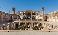
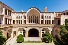
Kashan's architectural sights include:
- Abbāsi House
- Agha Bozorg Mosque
- Āmeri House
- Bazaar of Kashan
- Boroujerdi House
- Fin Garden
- Jalali Castle
- Jameh Mosque of Kashan
- Meydan Mosque
- Shrine of Abu Lu'lu'a (shrine dedicated to the assassin of Umar, the second Islamic caliph)
- Sultan Amir Ahmad Bathhouse
- Tabātabāei House
- Tabriziha Mosque
- Tepe Sialk
Today[edit]
Kashan is known for the manufacture of carpets, silk and other textiles.
.jpg)
Education[edit]


There are more than 10,000 students currently studying in various fields (e.g.:Applied sciences, Engineering, Art, Law, Medical sciences, Nano technology, literature, Carpet and Handicrafts, etc.) at universities of Kashan. Colleges and universities in Kashan include:
Accessibility[edit]
Kashan is connected via freeways to Isfahan and Natanz to the South, and Qom, which is an hour drive away to the north. Kashan railway station is along the main north–south railways of Iran. Kashan Airport reopened on 2 June 2016 after twenty years hiatus with an ATA Airlines flight from Mashhad International Airport.

Notable people[edit]
.jpg)
- David Alliance, Baron Alliance
- Ghyath ad-Din Jamshid Kashani
- Kamal-ol-Molk
- Amir Ghafour
- Ehsan Hajsafi
- Javad Kazemian
- Mohsen Feyz Kashani
- Sohrab Sepehri
- Ustad Ali Maryam
- Afdal al-Din Kashani
- Reza Abbasi
- Sani ol molk
- Kalim Kashani
- Muhtasham Kashani
- Ghotb Ravandi
- Saeed Hajjarian
- Mohammad Motamedi
- Mulla Muhammad Mahdi Naraqi
- Molla Fathollah Kashani
- Sani ol molk
- Moluk Zarabi
- Pari Zangeneh
Twin towns – sister cities[edit]
 Neishabour, Iran
Gallery[edit]
-

-

-

-
 Interior of Tabatabaeis House
 -
-
 Chardin Caravanseray
 -

-
 Soleimaniye spring
 -
 A manufactory of rose water in Kashan
 -
 Shrine of Abu Lu'lu'a, not far from Fin Garden
 -

-
 interior of Soltan Amir Ahmad Bathhouse
 -

-
 Darre Pariyan (Angels Valley)
 -

-
 Friday Mosque of Kashan
 -
 Sultan Amir Ahmad Mosque
 -
 Abbasi House


See also[edit]
- Aran va Bidgol
- Iranian Architecture
- Kashan rug
- List of the historical structures in the Isfahan province
- Maranjab Desert
- Namak lake
- Sialk - Kashan's ancient architecture.
- Traditional Persian residential architecture
References[edit]
- ^ OpenStreetMap contributors (16 June 2023). "Kashan, Kashan County" (Map). OpenStreetMap. Retrieved 16 June 2023.
- ^ a b "Census of the Islamic Republic of Iran, 1395 (2016)". AMAR (in Persian). The Statistical Center of Iran. p. 10. Archived from the original (Excel) on 19 October 2020. Retrieved 19 December 2022.
- ^ Kashan can be found at GEOnet Names Server, at this link, by opening the Advanced Search box, entering "-3069961" in the "Unique Feature Id" form, and clicking on "Search Database".
- ^ Henry Yule, Cathay and the Way Thither, Volume II, edited by Henri Cordier for the Hakluyt Society, 1913, p. 106, FN 4.
- ^ Habibi, Hassan (21 June 1369). "Approval of the organization and chain of citizenship of the elements and units of the national divisions of Isfahan province, centered in the city of Isfahan". Lamtakam (in Persian). Ministry of Interior, Defense Political Commission of the Government Board. Archived from the original on 4 February 2024. Retrieved 4 February 2024.
- ^ "Census of the Islamic Republic of Iran, 1385 (2006)". AMAR (in Persian). The Statistical Center of Iran. p. 10. Archived from the original (Excel) on 20 September 2011. Retrieved 25 September 2022.
- ^ "Census of the Islamic Republic of Iran, 1390 (2011)". Syracuse University (in Persian). The Statistical Center of Iran. p. 10. Archived from the original (Excel) on 17 January 2023. Retrieved 19 December 2022.
- ^ Biglari, F. (2004) The Preliminary Survey of Paleolithic Sites in the Kashan region., In S.M. Shahmirzadi (ed.), The Silversmiths of Sialk (Sialk Reconsideration Project), Report No. 2: 151-168. Archaeological Research Center. Iranian Cultural Heritage Organization,Tehran. (In Persian)
- ^ Shidrang, S 2009 A Typo-technological Study of an Upper Paleolithic Collection from Sefid-Ab, Central Iran, In: M. Otte, F. Biglari, and J. Jaubert (eds), Iran Palaeolithic. pp. 47–56, Proceedings of the XV World Congress UISPP, Lisbonne, Vol. 28, BAR International Series 1968
- ^ Elgood, Cyril. A Medical History of Persia and the Eastern Caliphate: From the Earliest Times Until the Year A.D. 1932. Cambridge Library Collection - History of Medicine. Cambridge University Press, 2010. ISBN 1108015883 p. 34
- ^ Henry Yule, Cathay and the Way Thither, Volume II, edited by Henri Cordier for the Hakluyt Society, 1913, p. 106.
- ^ Johnson, Rosemary Stanfield (1994). "Sunni Survival in Safavid Iran: Anti‐Sunni Activities During the Reign of Tahmasp I". Iranian Studies. 27 (1–4): 123–133. doi:10.1080/00210869408701823. JSTOR 4310889. p. 127, note 23. On Abu Lu'lu'a, see Pellat, Charles (2011). "Abū Loʾloʾa". In Yarshater, Ehsan (ed.). Encyclopaedia Iranica.
- ^ Roy P. Mottahedeh (19 January 2023). In the Shadow of the Prophet Essays in Islamic History (ebook). Oneworld Publications. ISBN 9780861545612. Retrieved 2 December 2023.
Ulugh Beg, one of most mathematically gifted rulers of the medieval era. Jamshid's enormous talent had supposedly been immediately recognized by another astronomer, on discovering him in an astrolabe shop in Kashan.98
- ^ David Durand-Guédy; Jürgen Paul; Roy Mottahedeh (2020). Cities of Medieval Iran. Brill. p. 420. ISBN 9789004434332. Retrieved 2 December 2023.
Kashan, showing that the latter also understood mathematics and astronomy. Applying the characteristic mix of ... Qara-Qoyunlu and subsequently the Aq-Qoyunlu.
- ^ "Kashan". www.visitiran.ir. Retrieved 17 March 2023.
- ^ Foundation, Encyclopaedia Iranica. "Welcome to Encyclopaedia Iranica". iranicaonline.org. Retrieved 17 March 2023.
External links[edit]
- Kashan Municipality
- Ghaffari Clan of Kashan
- University of Kashan
- Kashan University of medical sciences
- Islamic Azad university of Kashan
- Kashan Culture Foundation
- Art from Kashan at the Metropolitan Museum of Art
| National | |
|---|---|
| Geographic | |

| Capital | |||||||||||||||||||||||||||||||||||||||||||
|---|---|---|---|---|---|---|---|---|---|---|---|---|---|---|---|---|---|---|---|---|---|---|---|---|---|---|---|---|---|---|---|---|---|---|---|---|---|---|---|---|---|---|---|
| Districts |
| ||||||||||||||||||||||||||||||||||||||||||
| Periods |
|  | ||||
|---|---|---|---|---|---|---|
| Types | ||||||
| Elements | ||||||
| Traditional cities | ||||||
| Theory and analysis | ||||||
| Lists | ||||||