
Juli District
Juli
Chulli | |
|---|---|
 | |
| Country | |
| Region | Puno |
| Province | Chucuito |
| Capital | Juli |
| Government | |
| • Mayor | Justo Apaza Delgado (2019-2022) |
| Area | |
| • Total | 720.38 km2 (278.14 sq mi) |
| Elevation | 3,868 m (12,690 ft) |
| Population | |
| • Total | 23,741 |
| • Density | 33/km2 (85/sq mi) |
| Time zone | UTC-5 (PET) |
| UBIGEO | 210401 |

Juli District is one of seven districts of the Chucuito Province in Puno Region, Peru.[1]
Geography[edit]
One of the highest peaks of the district is K'isini at approximately 4,600 m (15,100 ft). Other mountains are listed below:[2]
History[edit]
Juli is mentioned as the third site where a printing press was established in the Americas, in 1612, following one in Mexico and another in Lima.[3]
Ethnic groups[edit]
The people in the district are mainly indigenous citizens of Aymara descent. Aymara is the language which the majority of the population (68.67%) learnt to speak in childhood, 30.56% of the residents started speaking using the Spanish language (2007 Peru Census).[4]
Climate[edit]
| Climate data for Juli (elevation 3,830 m (12,570 ft), 1991–2020 normals) | |||||||||||||
|---|---|---|---|---|---|---|---|---|---|---|---|---|---|
| Month | Jan | Feb | Mar | Apr | May | Jun | Jul | Aug | Sep | Oct | Nov | Dec | Year |
| Mean daily maximum °C (°F) | 14.0 (57.2) |
14.1 (57.4) |
14.1 (57.4) |
14.3 (57.7) |
13.8 (56.8) |
12.9 (55.2) |
12.8 (55.0) |
13.3 (55.9) |
14.0 (57.2) |
14.8 (58.6) |
15.3 (59.5) |
14.8 (58.6) |
14.0 (57.2) |
| Mean daily minimum °C (°F) | 5.2 (41.4) |
5.3 (41.5) |
5.0 (41.0) |
3.6 (38.5) |
1.0 (33.8) |
−0.6 (30.9) |
−0.8 (30.6) |
0.3 (32.5) |
2.1 (35.8) |
3.7 (38.7) |
4.6 (40.3) |
5.3 (41.5) |
2.9 (37.2) |
| Average precipitation mm (inches) | 215.8 (8.50) |
182.2 (7.17) |
157.2 (6.19) |
50.2 (1.98) |
11.6 (0.46) |
5.3 (0.21) |
7.3 (0.29) |
14.2 (0.56) |
23.6 (0.93) |
45.0 (1.77) |
49.7 (1.96) |
123.4 (4.86) |
885.5 (34.88) |
| Source: National Meteorology and Hydrology Service of Peru[5] | |||||||||||||
Authorities[edit]
Mayors[edit]
- 2011-2014: Juan Ludgerio Aguilar Olivera.
- 2007-2010: Eugenio Barbaito Constanza.
Gallery[edit]
-
 Mural paintings, Juli
 -
 Mural paintings, Juli
 -
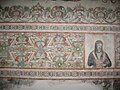 Mural paintings, Juli


See also[edit]
References[edit]
- ^ (in Spanish) Instituto Nacional de Estadística e Informática. Banco de Información Distrital Archived 2008-04-23 at the Wayback Machine. Retrieved April 11, 2008.
- ^ escale.minedu.gob.pe/ UGEL map Chucuito Province (Puno Region)
- ^ Suzanne Ackerson-Addor in Journal of the International Association of Paper Historians The first printing press was set up in Mexico, the second one in Peru 1584. The latter was organized by Jesuit Fathers. Later on printing presses were set up in Juli (earlier Peru, today Bolivia) 1612,
- ^ inei.gob.pe Archived 2013-01-27 at the Wayback Machine INEI, Peru, Censos Nacionales 2007, Frequencias: Preguntas de Población: Idioma o lengua con el que aprendió hablar (in Spanish)
- ^ "Normales Climáticas Estándares y Medias 1991-2020". National Meteorology and Hydrology Service of Peru. Archived from the original on 21 August 2023. Retrieved 25 October 2023.
External links[edit]
| |
|---|---|
| Azángaro | |
| Carabaya | |
| Chucuito | |
| El Collao | |
| Huancané | |
| Lampa | |
| Melgar | |
| Moho | |
| Puno | |
| San Antonio de Putina | |
| San Román | |
| Sandia | |
| Yunguyo | |
16°12′49″S 69°27′31″W / 16.2135°S 69.4586°W
This Puno Region geography article is a stub. You can help Wikipedia by expanding it. |