
Haghartsin, Armenia
Haghartsin
Հաղարծին | |
|---|---|
 A view of Haghartsin | |
 Haghartsin  Haghartsin | |
| Coordinates: 40°46′41″N 44°57′45″E / 40.77806°N 44.96250°E | |
| Country | Armenia |
| Province | Tavush |
| Municipality | Dilijan |
| Government | |
| • Mayor | Sargis Poghosyan |
| Population | |
| • Total | 3,791 |
| Time zone | UTC+4 (AMT) |
| Haghartsin, Armenia at GEOnet Names Server | |
Haghartsin (Armenian: Հաղարծին) is a village in the Dilijan Municipality of the Tavush Province of Armenia. The 13th-century Haghartsin Monastery is located around 8 km northwest of the village.
Toponymy[edit]
It was founded in 1815 as Jarkhech by Prince Jar Artsruni. In 1940, the village was renamed Kuybyshev after the Soviet politician Valerian Kuybyshev.[2] In 1992, the village was renamed Haghartsin, after the nearby Haghartsin Monastery.
Gallery[edit]
-
 Nearby 13th-century Haghartsin Monastery
 -
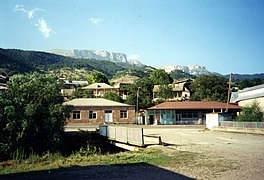 Haghartsin
 -
 Haghartsin Monastery
 -
 Nature around Haghartsin
 -
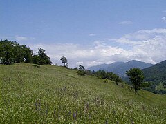 Nature around Haghartsin
 -
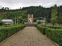 WWII monument
 -
 Khachkars
.jpg)


.jpg)

References[edit]
- ^ Statistical Committee of Armenia. "The results of the 2011 Population Census of Armenia" (PDF).
- ^ Kiesling, Rediscovering Armenia, p. 109, available online at the US embassy to Armenia's website Archived 2008-06-26 at the Wayback Machine
External links[edit]
Wikimedia Commons has media related to Haghartsin.
Capital: Ijevan | ||
| Urban settlements |  | |
| Berd Municipality | ||
| Dilijan Municipality | ||
| Ijevan Municipality | ||
| Noyemberyan Municipality | ||
This article about a location in Tavush Province, Armenia is a stub. You can help Wikipedia by expanding it. |