
File:World petroleum systems.png

Size of this preview: 800 × 428 pixels. Other resolutions: 320 × 171 pixels | 640 × 342 pixels | 1,024 × 548 pixels | 1,280 × 684 pixels | 2,560 × 1,369 pixels | 6,304 × 3,371 pixels.
Original file (6,304 × 3,371 pixels, file size: 566 KB, MIME type: image/png)
| This is a file from the Wikimedia Commons. Information from its description page there is shown below. Commons is a freely licensed media file repository. You can help. |
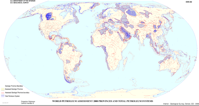
- Source: United States Geological Survey (USGS) World Petroleum Assessment 2000
- Map of World Petroleum Assessment 2000 Provinces and Total Petroleum Systems
- Thin red lines mark geologic province boundaries.
- Thick red lines mark assessed geologic province boundaries.
- Blue areas are Total Petroleum Systems.
United States areas are not included.
Source: http://pubs.usgs.gov/dds/dds-060/wrldmp2.html ; original upload English Wikipedia, 10 August 2005 by SEWilco en:Image:World petroleum systems.png
This image is in the public domain in the United States because it only contains materials that originally came from the United States Geological Survey, an agency of the United States Department of the Interior. For more information, see the official USGS copyright policy.
|
File history
Click on a date/time to view the file as it appeared at that time.
| Date/Time | Thumbnail | Dimensions | User | Comment | |
|---|---|---|---|---|---|
| current | 03:01, 8 September 2005 | | 6,304 × 3,371 (566 KB) | Saperaud~commonswiki | * Source: United States Geological Survey (USGS) World Petroleum Assessment 2000 ** Map of World Petroleum Assessment 2000 Provinces and Total Petroleum Systems * Thin red lines mark geologic province boundaries. * Thick red lines mark assessed ge |
File usage
The following pages on the English Wikipedia use this file (pages on other projects are not listed):