
File:Wilton house, Middlesex County.jpg

Size of this preview: 800 × 532 pixels. Other resolutions: 320 × 213 pixels | 640 × 426 pixels | 1,024 × 681 pixels | 1,280 × 851 pixels | 2,560 × 1,702 pixels | 6,016 × 4,000 pixels.
Original file (6,016 × 4,000 pixels, file size: 6.19 MB, MIME type: image/jpeg)
| This is a file from the Wikimedia Commons. Information from its description page there is shown below. Commons is a freely licensed media file repository. You can help. |
|
This is an image of a place or building that is listed on the National Register of Historic Places in the United States of America. Its reference number is 79003055. |
| Camera location | | View this and other nearby images on: OpenStreetMap |
|---|
| Description |
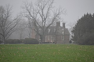
English: Distant view from the north of the Wilton plantation house, located on State Route 3 north of its crossing of the Piankatank River in eastern Middlesex County, Virginia, United States. Built in 1763, it is listed on the National Register of Historic Places. |
||
| Date | Taken on 21 January 2017 | ||
| Source | Own work | ||
| Author | Nyttend | ||
| Permission (Reusing this file) |
|
File history
Click on a date/time to view the file as it appeared at that time.
| Date/Time | Thumbnail | Dimensions | User | Comment | |
|---|---|---|---|---|---|
| current | 17:54, 7 February 2017 | | 6,016 × 4,000 (6.19 MB) | Nyttend | {{NRHP|79003055}} {{Location|37|31|47|N|76|25|24|W}} {{Information |Description={{en|Distant view from the north of the {{w|Wilton (Wilton, Virginia)|Wilton plantation house}}, located on {{w|Virginia State Route 3|State Route 3}} north of its crossing... |
File usage
The following pages on the English Wikipedia use this file (pages on other projects are not listed):
Global file usage
The following other wikis use this file:
- Usage on www.wikidata.org