
File:Vergleich Flughafen Deutschland.png

Size of this preview: 470 × 599 pixels. Other resolutions: 188 × 240 pixels | 376 × 480 pixels | 602 × 768 pixels | 803 × 1,024 pixels | 2,349 × 2,994 pixels.
Original file (2,349 × 2,994 pixels, file size: 3.46 MB, MIME type: image/png)
| This is a file from the Wikimedia Commons. Information from its description page there is shown below. Commons is a freely licensed media file repository. You can help. |
Summary
| Description |
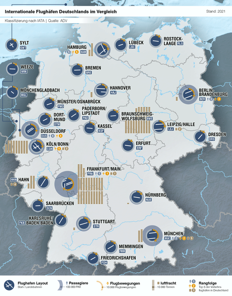
Deutsch: Internationale Flughäfen Deutschlands im Vergleich |
||
| Date | |||
| Source |
Own work Grundlage: Relief Map of Germany.svg Quelle: Liste der Verkehrsflughäfen in Deutschland, Stand: 2015 |
||
| Author | CellarDoor85 (Robert Aehnelt) | ||
| Permission (Reusing this file) |
I, the copyright holder of this work, hereby publish it under the following license: This file is licensed under the Creative Commons Attribution-Share Alike 3.0 Unported license.
|
||
| PNG development |
|

File history
Click on a date/time to view the file as it appeared at that time.
| Date/Time | Thumbnail | Dimensions | User | Comment | |
|---|---|---|---|---|---|
| current | 10:19, 22 November 2022 | | 2,349 × 2,994 (3.46 MB) | DerLudonaut | 2021 +alle Flgh. nach IATA |
| 09:24, 23 June 2019 |  | 2,120 × 2,701 (2.74 MB) | DerLudonaut | 2018 | |
| 20:15, 24 November 2016 |  | 2,442 × 3,113 (4.9 MB) | DerLudonaut | 2015 | |
| 20:34, 2 June 2013 |  | 2,500 × 3,182 (3.95 MB) | DerLudonaut | corr | |
| 15:50, 2 June 2013 |  | 2,500 × 3,185 (3.95 MB) | DerLudonaut | Verbesserungen laut Kartenwerkstatt | |
| 10:23, 31 May 2013 |  | 2,500 × 3,208 (3.81 MB) | DerLudonaut | {{Information |Description ={{de|1=Internationale Flughäfen Deutschlands im Vergleich}} |Source ={{own}} <br/> Grundlage: Relief Map of Germany <br/> Quelle: [[:de:Liste_der_Verkehrsflughäfen_in_Deutsch... |
File usage
The following pages on the English Wikipedia use this file (pages on other projects are not listed):
Global file usage
The following other wikis use this file:
- Usage on de.wikipedia.org
- Usage on de.wikivoyage.org
- Usage on fa.wikipedia.org
- Usage on it.wikipedia.org
- Usage on pt.wikipedia.org
- Usage on uk.wikipedia.org
- Usage on zh.wikipedia.org