
File:Urartu in comparison with states in 2008-en.svg

Size of this PNG preview of this SVG file: 800 × 513 pixels. Other resolutions: 320 × 205 pixels | 640 × 410 pixels | 1,024 × 657 pixels | 1,280 × 821 pixels | 2,560 × 1,641 pixels | 2,714 × 1,740 pixels.
Original file (SVG file, nominally 2,714 × 1,740 pixels, file size: 931 KB)
| This is a file from the Wikimedia Commons. Information from its description page there is shown below. Commons is a freely licensed media file repository. You can help. |
Summary
| Description |
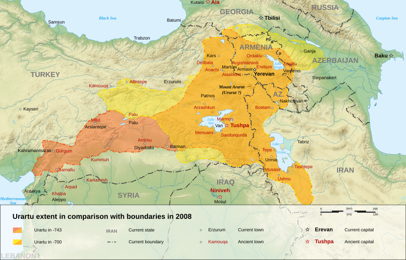
English: English map of a comparison with kingdom of Urartu in -743 and -700, and current states boundaries in 2008.
Français : Carte en anglais, comparant les frontières du royaume d'Urartu en -743 et -700, et les frontières des États actuels en 2008.
فارسی: نقشهای به زبان انگلیسی از پادشاهی اورارتو در ۷۴۳ و ۷۰۰ پیش از میلاد. |
||
| Date | |||
| Source |
Own work.
Sources :
Softwares used :
Other data :
|
||
| Author | Sémhur | ||
| Other versions |
See Urartu.
| ||
| Attribution (required by the license) | © Sémhur / Wikimedia Commons / | ||
| SVG | W3C-validity not checked.
|
||
| Atelier graphique |


| Camera location | | View this and other nearby images on: OpenStreetMap |
|---|
Licensing
I, the copyright holder of this work, hereby publish it under the following licenses:
| Copyleft: This work of art is free; you can redistribute it and/or modify it according to terms of the Free Art License. You will find a specimen of this license on the Copyleft Attitude site as well as on other sites. |
This file is licensed under the Creative Commons Attribution-Share Alike 4.0 International, 3.0 Unported, 2.5 Generic, 2.0 Generic and 1.0 Generic license.
- You are free:
- to share – to copy, distribute and transmit the work
- to remix – to adapt the work
- Under the following conditions:
- attribution – You must give appropriate credit, provide a link to the license, and indicate if changes were made. You may do so in any reasonable manner, but not in any way that suggests the licensor endorses you or your use.
- share alike – If you remix, transform, or build upon the material, you must distribute your contributions under the same or compatible license as the original.
You may select the license of your choice.
File history
Click on a date/time to view the file as it appeared at that time.
| Date/Time | Thumbnail | Dimensions | User | Comment | |
|---|---|---|---|---|---|
| current | 17:37, 8 January 2008 | | 2,714 × 1,740 (931 KB) | Sémhur | == Description == {{Information |Description= {{en| English map of a comparison with kingdom of Urartu in -743 and -700, and current states boundaries in 2008.}} {{fr| Carte en anglais, comparant les frontières du royaume d'Urartu en -743 et -700, et les |
File usage
The following pages on the English Wikipedia use this file (pages on other projects are not listed):
Global file usage
The following other wikis use this file:
- Usage on eo.wikipedia.org
- Usage on et.wikipedia.org
- Usage on fa.wikipedia.org
- Usage on nn.wikipedia.org
- Usage on pl.wikipedia.org
- Usage on tr.wikipedia.org