
File:The Russian Empire-en.svg

Size of this PNG preview of this SVG file: 800 × 407 pixels. Other resolutions: 320 × 163 pixels | 640 × 325 pixels | 1,024 × 520 pixels | 1,280 × 650 pixels | 2,560 × 1,301 pixels | 3,121 × 1,586 pixels.
Original file (SVG file, nominally 3,121 × 1,586 pixels, file size: 1.95 MB)
| This is a file from the Wikimedia Commons. Information from its description page there is shown below. Commons is a freely licensed media file repository. You can help. |
Summary
| Description |
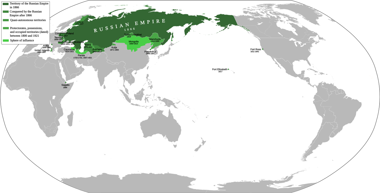
English: Russiam Empire. Territory (1866). Protectorates, overseas territories and occupied territories (dated) between 1800 and 1917. Sphere of influence. 日本語: ロシア帝国 1866年のロシア帝国領域 1800年から1917年までに保護領、租借地、占領地などとした地域 勢力圏 |
| Date | |
| Source |
Own work
|
| Author | Milenioscuro |
| Other versions |
|


Licensing
I, the copyright holder of this work, hereby publish it under the following license:
This file is licensed under the Creative Commons Attribution-Share Alike 3.0 Unported license.
- You are free:
- to share – to copy, distribute and transmit the work
- to remix – to adapt the work
- Under the following conditions:
- attribution – You must give appropriate credit, provide a link to the license, and indicate if changes were made. You may do so in any reasonable manner, but not in any way that suggests the licensor endorses you or your use.
- share alike – If you remix, transform, or build upon the material, you must distribute your contributions under the same or compatible license as the original.
File history
Click on a date/time to view the file as it appeared at that time.
| Date/Time | Thumbnail | Dimensions | User | Comment | |
|---|---|---|---|---|---|
| current | 20:22, 18 May 2023 | | 3,121 × 1,586 (1.95 MB) | Teyvatism | File uploaded using svgtranslate tool (https://svgtranslate.toolforge.org/). Added translation for vi. |
| 06:49, 13 January 2022 |  | 3,121 × 1,586 (1.96 MB) | Scratchinghead | Major edits | |
| 15:54, 12 January 2022 |  | 3,121 × 1,586 (1.91 MB) | Scratchinghead | Some territories added, After 1866 added | |
| 16:35, 28 January 2021 |  | 3,121 × 1,586 (1.91 MB) | Mattesák | sagallo added | |
| 06:27, 12 September 2012 |  | 3,121 × 1,586 (1.91 MB) | Milenioscuro | conventions | |
| 06:23, 12 September 2012 |  | 3,121 × 1,586 (1.91 MB) | Milenioscuro | some corrections, and differentiated areas | |
| 01:54, 10 May 2011 |  | 3,121 × 1,586 (1.91 MB) | Milenioscuro | Uriankhai protectorate (Tuva) | |
| 23:09, 7 May 2011 |  | 3,121 × 1,586 (1.85 MB) | Milenioscuro | {{Information |Description ={{en|1=Russiam Empire (1800-1866)}} |Source ={{own}} |Author =Shadowxfox |Date =07-05-2011 |Permission = |other_versions = }} Category:Maps of the Russian Empire |
File usage
The following pages on the English Wikipedia use this file (pages on other projects are not listed):
Global file usage
The following other wikis use this file:
- Usage on ar.wikipedia.org
- Usage on azb.wikipedia.org
- Usage on ba.wikipedia.org
- Usage on bg.wikipedia.org
- Usage on bh.wikipedia.org
- Usage on ca.wikipedia.org
- Usage on cs.wikipedia.org
- Usage on da.wikipedia.org
- Usage on de.wikipedia.org
- Usage on fa.wikipedia.org
- Usage on fi.wikipedia.org
- Usage on id.wikipedia.org
- Usage on it.wikipedia.org
- Usage on ja.wikipedia.org
- Usage on kn.wikipedia.org
- Usage on ml.wikipedia.org
- Usage on ms.wikipedia.org
- Usage on my.wikipedia.org
- Usage on ne.wikipedia.org
- Usage on nl.wikipedia.org
- Usage on pap.wikipedia.org
- Usage on pl.wikipedia.org
- Usage on qu.wikipedia.org
- Usage on ro.wikipedia.org
- Usage on sq.wikipedia.org
- Usage on th.wikipedia.org
- Usage on tt.wikipedia.org
- Usage on uk.wikipedia.org
View more global usage of this file.