
File:Thai Canal map-de.jpg
Size of this preview: 461 × 599 pixels. Other resolutions: 184 × 240 pixels | 369 × 480 pixels | 591 × 768 pixels | 1,126 × 1,464 pixels.
Original file (1,126 × 1,464 pixels, file size: 809 KB, MIME type: image/jpeg)
| This is a file from the Wikimedia Commons. Information from its description page there is shown below. Commons is a freely licensed media file repository. You can help. |

|
This map image could be re-created using vector graphics as an SVG file. This has several advantages; see Commons:Media for cleanup for more information. If an SVG form of this image is available, please upload it and afterwards replace this template with
{{vector version available|new image name}}.
It is recommended to name the SVG file “Thai Canal map-de.svg”—then the template Vector version available (or Vva) does not need the new image name parameter. |


| Description |
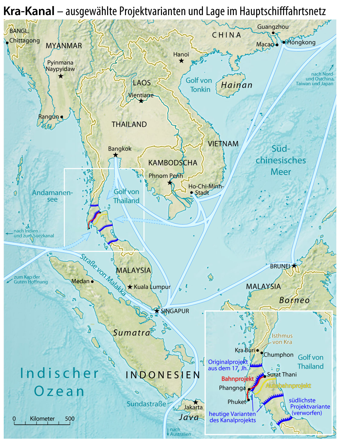
Deutsch: Karte mit ausgewählten Projektvarianten des Kra-Kanals
English: Map of selected project variants of the Thai Canal |
|||
| Date | see file history | |||
| Source | CIA World Factbook | |||
| Author | Maximilian Dörrbecker (Chumwa) | |||
| Permission (Reusing this file) |
|

File history
Click on a date/time to view the file as it appeared at that time.
| Date/Time | Thumbnail | Dimensions | User | Comment | |
|---|---|---|---|---|---|
| current | 05:44, 16 March 2010 | | 1,126 × 1,464 (809 KB) | Chumwa | südliche Variante hinzugefügt |
| 06:12, 15 March 2010 |  | 1,126 × 1,464 (798 KB) | Chumwa | Hauptschiffahrtsrouten → Hauptschifffahrtsrouten | |
| 11:17, 14 March 2010 |  | 1,126 × 1,466 (798 KB) | Chumwa | Straße von Malakka war doppelt beschriftet | |
| 10:20, 14 March 2010 |  | 1,126 × 1,466 (803 KB) | Chumwa | Kartentitel geändert | |
| 10:13, 14 March 2010 |  | 1,126 × 1,466 (796 KB) | Chumwa | Überarbeitung | |
| 21:52, 13 March 2010 |  | 1,126 × 1,466 (894 KB) | Chumwa | {{Information |Description={{de|Karte mit ausgewählten Projektvarianten des Kra-Kanals}} {{en|Map of selected project variants of the Thai Canal}} |Author=Maximilian Dörrbecker (Chumwa) |Source=[https://www.cia.go |
File usage
The following pages on the English Wikipedia use this file (pages on other projects are not listed):
Global file usage
The following other wikis use this file:
- Usage on ar.wikipedia.org
- Usage on bn.wikipedia.org
- Usage on cs.wikipedia.org
- Usage on de.wikipedia.org
- Usage on fr.wikipedia.org
- Usage on id.wikipedia.org
- Usage on it.wikipedia.org
- Usage on ja.wikipedia.org
- Usage on ko.wikipedia.org
- Usage on ms.wikipedia.org
- Usage on no.wikipedia.org
- Usage on pt.wikipedia.org
- Usage on ro.wikipedia.org
- Usage on ru.wikipedia.org
- Usage on sl.wikipedia.org
- Usage on sv.wikipedia.org
- Usage on ta.wikipedia.org
- Usage on th.wikipedia.org
- Usage on uk.wikipedia.org
- Usage on www.wikidata.org
- Usage on zh.wikipedia.org