
File:Tarah Kashijiki (191).jpg

Size of this preview: 800 × 333 pixels. Other resolutions: 320 × 133 pixels | 640 × 266 pixels | 1,024 × 426 pixels | 1,280 × 533 pixels | 3,636 × 1,514 pixels.
Original file (3,636 × 1,514 pixels, file size: 2.03 MB, MIME type: image/jpeg)
| This is a file from the Wikimedia Commons. Information from its description page there is shown below. Commons is a freely licensed media file repository. You can help. |
Summary
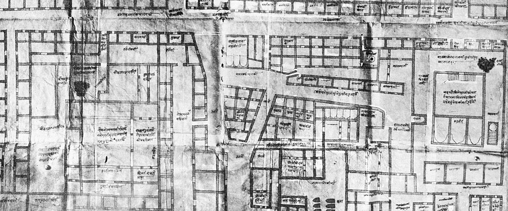
| Description |
English: Documents physical dimensions, land use, and sociocultural ownership of buildings and spaces along the street that connected the Gyan Vapi precinct to Manikarnika ghat to the south and the Mughal administrative center to its north.Tarah Number 191, as cataloged in the records of Maharaja Sawai Man Singh II Museum. |
| Date | circa 1700 |
| Source | Desai, Madhuri (2017). "Palimpsets and Authority". Banaras Reconstructed: Architecture and Sacred Space in a Hindu Holy City p. 38 University of Washington Press. ISBN 978-0-295-74160-4. |
| Author | Surveyors of Bishan Singh |
| Other versions |
.jpg)
.jpg)
Licensing
|
This work is in the public domain in its country of origin and other countries and areas where the copyright term is the author's life plus 70 years or fewer. This work is in the public domain in the United States because it was published (or registered with the U.S. Copyright Office) before January 1, 1929. | |
| This file has been identified as being free of known restrictions under copyright law, including all related and neighboring rights. | |
File history
Click on a date/time to view the file as it appeared at that time.
| Date/Time | Thumbnail | Dimensions | User | Comment | |
|---|---|---|---|---|---|
| current | 14:12, 27 June 2022 | | 3,636 × 1,514 (2.03 MB) | TrangaBellam | Uploaded a work by Surveyors of Bishan Singh from Desai, Madhuri (2017). "Palimpsets and Authority". ''Banaras Reconstructed: Architecture and Sacred Space in a Hindu Holy City'' p. 38 University of Washington Press. ISBN 978-0-295-74160-4. with UploadWizard |
File usage
No pages on the English Wikipedia use this file (pages on other projects are not listed).
.jpg)