
File:Tamil Nadu Literacy Map 2011.png
Size of this preview: 542 × 599 pixels. Other resolutions: 217 × 240 pixels | 434 × 480 pixels | 695 × 768 pixels | 1,122 × 1,240 pixels.
Original file (1,122 × 1,240 pixels, file size: 235 KB, MIME type: image/png)
| This is a file from the Wikimedia Commons. Information from its description page there is shown below. Commons is a freely licensed media file repository. You can help. |
Summary
| Description |
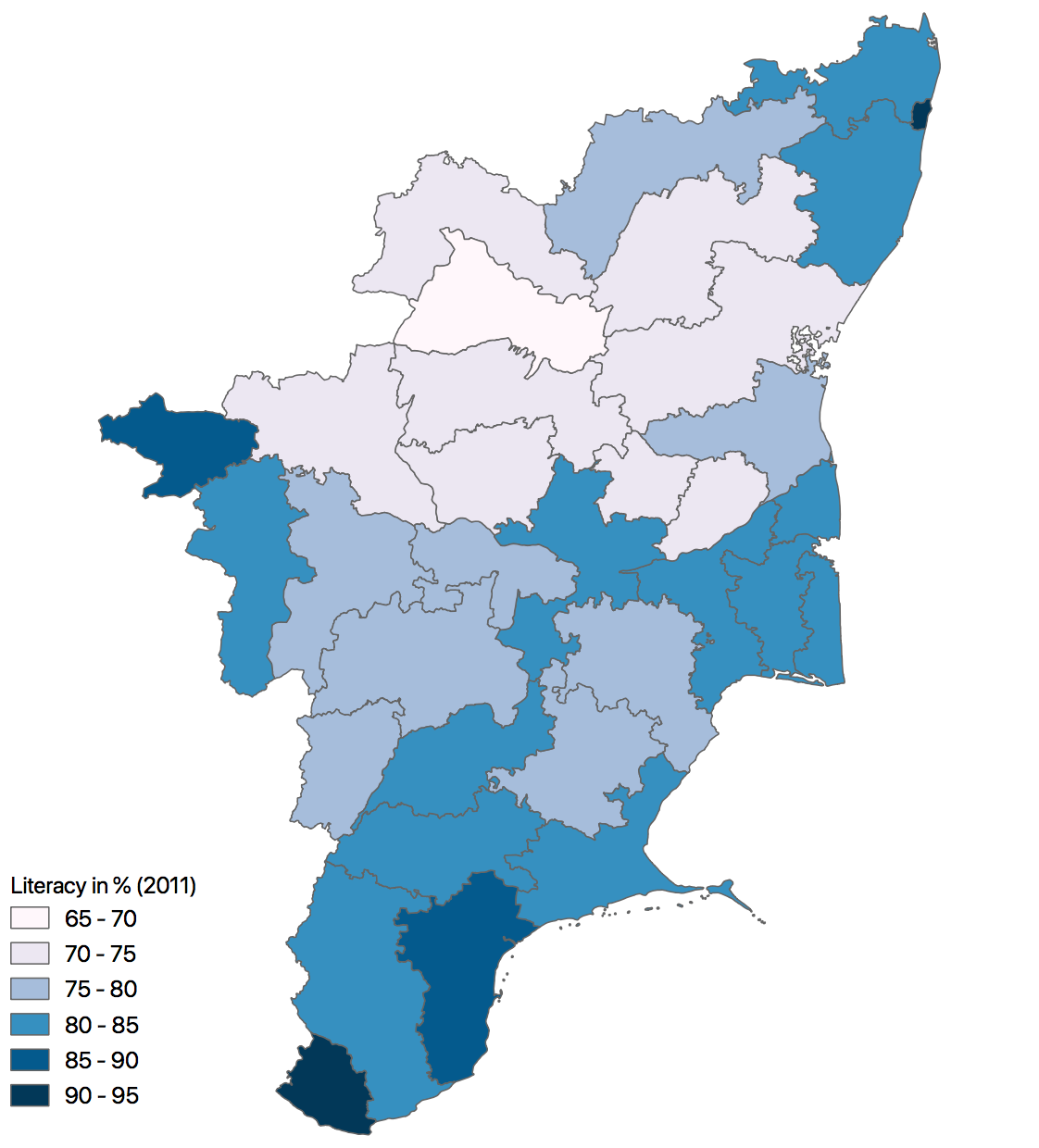
English: A Choropleth map of Tamilnadu state, India, showing the district wise literacy rate in 2011. |
| Date | |
| Source |
Own work English: This was created using the GADM vector data and 2011 Census provisional totals using QGIS. Refer data here |
| Author | Arunmozhi |
Licensing
I, the copyright holder of this work, hereby publish it under the following license:
This file is licensed under the Creative Commons Attribution-Share Alike 3.0 Unported license.
- You are free:
- to share – to copy, distribute and transmit the work
- to remix – to adapt the work
- Under the following conditions:
- attribution – You must give appropriate credit, provide a link to the license, and indicate if changes were made. You may do so in any reasonable manner, but not in any way that suggests the licensor endorses you or your use.
- share alike – If you remix, transform, or build upon the material, you must distribute your contributions under the same or compatible license as the original.
File history
Click on a date/time to view the file as it appeared at that time.
| Date/Time | Thumbnail | Dimensions | User | Comment | |
|---|---|---|---|---|---|
| current | 13:02, 24 December 2018 | | 1,122 × 1,240 (235 KB) | Arunmozhi | Updated the map to meet the Wikipedia Gradient map conventions |
| 13:43, 17 October 2011 |  | 2,104 × 1,488 (424 KB) | Arunmozhi |
File usage
The following pages on the English Wikipedia use this file (pages on other projects are not listed):
Global file usage
The following other wikis use this file:
- Usage on ar.wikipedia.org
- Usage on ta.wikipedia.org