
File:Stallion-AAF-Airport-Diagram.png

Size of this preview: 564 × 599 pixels. Other resolutions: 226 × 240 pixels | 452 × 480 pixels | 1,020 × 1,084 pixels.
Original file (1,020 × 1,084 pixels, file size: 23 KB, MIME type: image/png)
| This is a file from the Wikimedia Commons. Information from its description page there is shown below. Commons is a freely licensed media file repository. You can help. |
Summary
| Description |
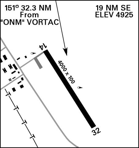
English: Airport Diagram for Stallion Army Airfield (95E) in Socorro Country, New Mexico |
| Date | |
| Source | DoD Flight Information Publication (Enroute) - VFR Supplement United States |
| Author | National Geospatial-Intelligence Agency |
Licensing
This image is a work of the United States National Geospatial-Intelligence Agency or one of its predecessor agencies. As a work of the U.S. federal government, the image is in the public domain.
|
 |
File history
Click on a date/time to view the file as it appeared at that time.
| Date/Time | Thumbnail | Dimensions | User | Comment | |
|---|---|---|---|---|---|
| current | 13:04, 18 October 2021 | | 1,020 × 1,084 (23 KB) | Recoil16 | Uploaded a work by National Geospatial-Intelligence Agency from [https://www.t6bdriver.com/uploads/6/4/7/7/64775059/vfr_19jul18.pdf] with UploadWizard |
File usage
The following pages on the English Wikipedia use this file (pages on other projects are not listed):