
File:St. Croix geologic map.png
No higher resolution available.
St._Croix_geologic_map.png (611 × 245 pixels, file size: 96 KB, MIME type: image/png)
| This is a file from the Wikimedia Commons. Information from its description page there is shown below. Commons is a freely licensed media file repository. You can help. |
Summary
| Description |
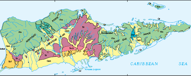
English: St. Croix geologic map, where Km is the Cretaceous Mt. Eagle Group, Kd is Cretaceous diorite, Kg is Cretaceous gabbro, Tbf is the Pliocene Blessing Formation, Tmb and Tlr are the Miocene Kingshall Limestone, Qab is Quaternary alluvium, and Qr is Quaternary reef. |
| Date | |
| Source | Geology and Hydrogeology of the Caribbean Islands Aquifer System of the Commonwealth of Puerto Rico and the U.S. Virgin Islands, USGS Professional Paper 1419 |
| Author | R.A. Renken, W.C. Ward, I.P. Gill, F. Gomez-Gomez, J. Rodriguez-Martinez |
Licensing
This image is in the public domain in the United States because it only contains materials that originally came from the United States Geological Survey, an agency of the United States Department of the Interior. For more information, see the official USGS copyright policy.
|
File history
Click on a date/time to view the file as it appeared at that time.
| Date/Time | Thumbnail | Dimensions | User | Comment | |
|---|---|---|---|---|---|
| current | 21:36, 16 December 2016 | 611 × 245 (96 KB) | Pi3.124 | User created page with UploadWizard |
File usage
The following pages on the English Wikipedia use this file (pages on other projects are not listed):