
File:Safavid Empire 1501 1722 AD.png
No higher resolution available.
Safavid_Empire_1501_1722_AD.png (620 × 428 pixels, file size: 20 KB, MIME type: image/png)
| This is a file from the Wikimedia Commons. Information from its description page there is shown below. Commons is a freely licensed media file repository. You can help. |

|
This historical map image could be re-created using vector graphics as an SVG file. This has several advantages; see Commons:Media for cleanup for more information. If an SVG form of this image is available, please upload it and afterwards replace this template with
{{vector version available|new image name}}.
It is recommended to name the SVG file “Safavid Empire 1501 1722 AD.svg”—then the template Vector version available (or Vva) does not need the new image name parameter. |
Summary
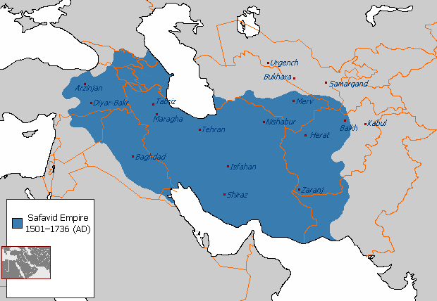
| Description | A map depicting the extent the Safavid Empire at its greatest extent under Ismail I. |
| Date | 29 August 2007 (original upload date) |
| Source | Own work |
| Author | Arab League at English Wikipedia |
| Other versions | العربيَّة |
Licensing
| This work has been released into the public domain by its author, Arab League at English Wikipedia. This applies worldwide. In some countries this may not be legally possible; if so: Arab League grants anyone the right to use this work for any purpose, without any conditions, unless such conditions are required by law. |
Original upload log
Transferred from en.wikipedia to Commons by KureCewlik81.
The original description page was here. All following user names refer to en.wikipedia.
- 2007-08-29 21:55 Arab League 620×429×8 (24314 bytes)
File history
Click on a date/time to view the file as it appeared at that time.
| Date/Time | Thumbnail | Dimensions | User | Comment | |
|---|---|---|---|---|---|
| current | 23:08, 1 January 2018 | | 620 × 428 (20 KB) | HistoryofIran | No consensus has been reached. You own nothing on this site, neither do I. |
| 22:59, 1 January 2018 |  | 620 × 428 (27 KB) | Qizilbash | Reverted. I don't know about your own maps. But the edits you have made here are historically incorrect. Borders regarding the reign of Abbas I has nothing to do with Ismail I. Please stop reverting. | |
| 21:03, 1 January 2018 |  | 620 × 428 (20 KB) | HistoryofIran | rv, take your concerns to the talk page | |
| 19:57, 30 December 2017 |  | 620 × 428 (27 KB) | Qizilbash | Reverted to version as of 15:03, 5 December 2010 (UTC). The map description says "under Ismail I", but there have been made changes relating to the reign of Abbas I. For a map of Abbas I, please look at: https://commons.wikimedia.org/wiki/File:Safavid_... | |
| 11:47, 18 April 2014 |  | 620 × 428 (20 KB) | Kwamikagami | Reverted to version as of 21:31, 17 April 2014 - inconsistent w being vassal states | |
| 10:43, 18 April 2014 |  | 620 × 428 (27 KB) | Jaqeli | Reverted to version as of 17:15, 17 April 2014 | |
| 21:31, 17 April 2014 |  | 620 × 428 (20 KB) | HistoryofIran | Removed disprutive edit; it is well known that eastern Georgia was part of the Safavid Empire. | |
| 17:15, 17 April 2014 |  | 620 × 428 (27 KB) | Jaqeli | Reverted to version as of 15:03, 5 December 2010 | |
| 16:54, 17 April 2014 |  | 620 × 428 (20 KB) | HistoryofIran | Made the map more accurate. | |
| 17:46, 11 April 2013 |  | 620 × 428 (20 KB) | HistoryofIran | {{subst:Upload marker added by en.wp UW}} {{Information |Description = {{en|Added Tbilisi on the map, it was also under Safavid rule.}} |Source = http://en.wikipedia.org/wiki/File:Safavid_Empire_1501_1722_AD.png |Date = 11. April 2013 |Author = Origina... |
File usage
The following pages on the English Wikipedia use this file (pages on other projects are not listed):
Global file usage
The following other wikis use this file:
- Usage on als.wikipedia.org
- Usage on an.wikipedia.org
- Usage on ar.wikipedia.org
- Usage on az.wikipedia.org
- Usage on az.wiktionary.org
- Usage on ba.wikipedia.org
- Usage on be.wikipedia.org
- Usage on bn.wikipedia.org
- Usage on bxr.wikipedia.org
- Usage on ceb.wikipedia.org
- Usage on ce.wikipedia.org
- Usage on ckb.wikipedia.org
- Usage on crh.wikipedia.org
- Usage on da.wikipedia.org
- Usage on de.wikipedia.org
- Usage on diq.wikipedia.org
- Usage on el.wikipedia.org
- Usage on eu.wikipedia.org
- Usage on fa.wikipedia.org
- Usage on fr.wikipedia.org
- Usage on hr.wikipedia.org
- Usage on hu.wikipedia.org
- Usage on hy.wikipedia.org
- Usage on hyw.wikipedia.org
- Usage on id.wikipedia.org
- Usage on id.wikibooks.org
- Usage on it.wikipedia.org
- Usage on lt.wikipedia.org
- Usage on mk.wikipedia.org
- Usage on ms.wikipedia.org
View more global usage of this file.