
File:Remains of Harperley Station - geograph.org.uk - 1313810.jpg
No higher resolution available.
Remains_of_Harperley_Station_-_geograph.org.uk_-_1313810.jpg (640 × 480 pixels, file size: 132 KB, MIME type: image/jpeg)
| This is a file from the Wikimedia Commons. Information from its description page there is shown below. Commons is a freely licensed media file repository. You can help. |
Summary
| Description |
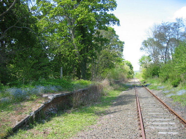
English: Remains of Harperley Station This is the north bound platform and the south bound no longer exists apart from a pile of rubble.
This was the remotest station on the branch with no public vehicular access. It was opened as a small halt to serve the nearby Harperley Hall and its estate in 1861 but no longer appeared in a public timetable after May 1864. It was extensively enlarged and reopened on 1.11.1892 to serve the local ganister (a siliceous clay) and timber contractor who were provided with sidings either side of the line. http://www.subbrit.org.uk/sb-sites/stations/h/harperley/index.shtml |
| Date | |
| Source | From geograph.org.uk |
| Author | Les Hull |
| Attribution (required by the license) | Les Hull / Remains of Harperley Station / |
| Camera location | | View this and other nearby images on: OpenStreetMap |
|---|
_heading:292.00&language=en)
| Object location | | View this and other nearby images on: OpenStreetMap |
|---|
_heading:292.00&language=en)
Licensing

|
This image was taken from the Geograph project collection. See this photograph's page on the Geograph website for the photographer's contact details. The copyright on this image is owned by Les Hull and is licensed for reuse under the Creative Commons Attribution-ShareAlike 2.0 license.
|
This file is licensed under the Creative Commons Attribution-Share Alike 2.0 Generic license.
Attribution: Les Hull
- You are free:
- to share – to copy, distribute and transmit the work
- to remix – to adapt the work
- Under the following conditions:
- attribution – You must give appropriate credit, provide a link to the license, and indicate if changes were made. You may do so in any reasonable manner, but not in any way that suggests the licensor endorses you or your use.
- share alike – If you remix, transform, or build upon the material, you must distribute your contributions under the same or compatible license as the original.
File history
Click on a date/time to view the file as it appeared at that time.
| Date/Time | Thumbnail | Dimensions | User | Comment | |
|---|---|---|---|---|---|
| current | 18:02, 27 February 2011 | | 640 × 480 (132 KB) | GeographBot | == {{int:filedesc}} == {{Information |description={{en|1=Remains of Harperley Station This is the north bound platform and the south bound no longer exists apart from a pile of rubble. This was the remotest station on the branch with no public vehicular |
File usage
The following pages on the English Wikipedia use this file (pages on other projects are not listed):
Global file usage
The following other wikis use this file:
- Usage on www.wikidata.org