
File:Regional Organizations Map.png

Original file (1,357 × 628 pixels, file size: 95 KB, MIME type: image/png)
| This is a file from the Wikimedia Commons. Information from its description page there is shown below. Commons is a freely licensed media file repository. You can help. |

|
Several vector versions of this file are available. These should be used in place of this PNG file when not inferior.
File:Regional Organizations Map.png →
For more information, see Help:SVG. |
Transferred from en.wikipedia to Commons by Maksim.
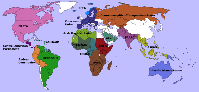
Global map showing several regional organizations of non-overlapping memberships. Created by User:Aris Katsaris, using commons:Image:BlankMap-World-v4-colored.png Aris Katsaris 21:33, 18 March 2006 (UTC)

|
Permission is granted to copy, distribute and/or modify this document under the terms of the GNU Free Documentation License, Version 1.2 or any later version published by the Free Software Foundation; with no Invariant Sections, no Front-Cover Texts, and no Back-Cover Texts. A copy of the license is included in the section entitled GNU Free Documentation License. |
| This file is licensed under the Creative Commons Attribution-Share Alike 3.0 Unported license. | ||
| ||
| This licensing tag was added to this file as part of the GFDL licensing update. |
| date/time | username | edit summary |
|---|---|---|
| 21:33, 18 March 2006 | en:User:Aris Katsaris | (reference to <a href="http://commons.wikimedia.org/wiki/Image:BlankMap-World-v4-colored.png" class='extiw' title="commons:Image:BlankMap-World-v4-colored.png">:commons:Image:BlankMap-World-v4-colored.png</a>) |
| 20:00, 5 December 2004 | en:User:Aris Katsaris | (Global map showing several regional organizations of non-overlapping memberships. Created by <a href="/wiki/User:Aris_Katsaris" title="User:Aris Katsaris">User:Aris Katsaris</a>. {{GFDL}}) |
Original upload log
Legend: (cur) = this is the current file, (del) = delete this old version, (rev) = revert to this old version.
Click on date to download the file or see the image uploaded on that date.
- (del) (cur) 21:27, 18 March 2006 . . en:User:Aris_Katsaris Aris Katsaris ( en:User_talk:Aris_Katsaris Talk) . . 1357x628 (73719 bytes) (updated using my :Image:BlankMap-World-v4-colored.png)
- (del) (rev) 20:48, 27 February 2006 . . en:User:Aris_Katsaris Aris Katsaris ( en:User_talk:Aris_Katsaris Talk) . . 1357x628 (66830 bytes) (Given how I'm including African Union in :Image:Continental Orgs Map, perhaps better to break the situation up a little more in this image, and show such smaller orgs instead. )
- (del) (rev) 01:57, 2 February 2006 . . en:User:Aris_Katsaris Aris Katsaris ( en:User_talk:Aris_Katsaris Talk) . . 1357x628 (2454440 bytes) (SAARC has grown, CIS has shrunk. Also uploading bigger pic.)
- (del) (rev) 20:31, 5 December 2004 . . en:User:Aris_Katsaris Aris Katsaris ( en:User_talk:Aris_Katsaris Talk) . . 679x314 (37360 bytes) (adding EFTA)
- (del) (rev) 20:00, 5 December 2004 . . en:User:Aris_Katsaris Aris Katsaris ( en:User_talk:Aris_Katsaris Talk) . . 679x314 (37100 bytes) (Global map showing several regional organizations of non-overlapping memberships. Created by en:User:Aris_Katsaris User:Aris Katsaris. { { GFDL } })
File history
Click on a date/time to view the file as it appeared at that time.
| Date/Time | Thumbnail | Dimensions | User | Comment | |
|---|---|---|---|---|---|
| current | 20:19, 21 January 2021 | | 1,357 × 628 (95 KB) | Rockfreak1949 | Brexit became official as of January 31, 2020 |
| 22:50, 4 February 2017 |  | 1,357 × 628 (26 KB) | GermanJoe | Reverted to version as of 19:59, 11 January 2016 (UTC) still a member | |
| 20:11, 4 February 2017 |  | 1,357 × 628 (95 KB) | BedrockPerson | Removing UK | |
| 19:59, 11 January 2016 |  | 1,357 × 628 (26 KB) | Hallel | Reverted to version as of 18:01, 10 July 2013 (UTC) | |
| 01:43, 28 June 2014 |  | 1,357 × 628 (68 KB) | Arief Zuhri | +East Timor | |
| 18:01, 10 July 2013 |  | 1,357 × 628 (26 KB) | Hektor Absurdus | + Montenegro, PNG compression | |
| 12:50, 5 July 2013 |  | 1,357 × 628 (69 KB) | Hektor Absurdus | EU - Croatia added | |
| 20:20, 23 April 2013 |  | 1,357 × 628 (86 KB) | Hallel | Adição da Venezuela ao Mercosul; Adição do Sudão do Sul; e outros Estados que existem de facto: http://en.wikipedia.org/wiki/List_of_states_with_limited_recognition | |
| 21:21, 15 March 2013 |  | 1,357 × 628 (68 KB) | Quite vivid blur | Nor officially is the Ukraine | |
| 12:12, 22 May 2012 |  | 1,357 × 628 (85 KB) | პაატა შ | Georgia is not member of "Commonwealth of independent states" |
File usage
More than 100 pages use this file. The following list shows the first 100 pages that use this file only. A full list is available.
- 2002 Prague summit
- Acronym Institute for Disarmament Diplomacy
- African Well Fund
- Agence de Coopération Culturelle et Technique
- Air Command and Control System
- Amazon Cooperation Treaty Organization
- Andean Group
- Apimondia
- Arab Cooperation Council
- Arab Fund for Economic and Social Development
- Asia Pacific Parliamentary Forum
- Asian Centre for Human Rights
- Asian Network of Major Cities 21
- Assemblée parlementaire de la Francophonie
- Association for History and Computing
- Association for Information Systems
- Association to Unite the Democracies
- Baltic Sea Trade Union Network
- Basic Income Earth Network
- Benelux Office for Intellectual Property
- Boardgame Players Association
- Carpathian Euroregion
- Centre Virtuel de la Connaissance sur l'Europe
- Christian Democrat Organization of America
- Coalition for International Justice
- Committee on the Safety of Nuclear Installations
- DATA
- Democratic Pacific Union
- Disaster Resource Network
- Eurocadres
- European Science Fiction Society
- Federation of Associations for Hunting and Conservation of the EU
- Fédération Internationale Féline
- G10 (agricultural)
- G33 (developing countries)
- GISCorps
- Global public–private partnership
- Grandmothers for Peace
- Group of 22
- Group of Nine
- HELCOM
- ITU-D
- Indo-Pacific Conservation Alliance
- Inter-American Defense Board
- Inter-American Telecommunication Commission
- International Advisory and Monitoring Board
- International Animated Film Association
- International Association for the Advancement of Teaching and Research in Intellectual Property
- International Association of Academies
- International Auxiliary Language Association
- International Committee for Democracy in Cuba
- International Comparative Literature Association
- International Dance Council
- International Ergonomics Association
- International Federation for Information and Documentation
- International Foundation for Gender Education
- International Fund for Ireland
- International Maritime Bureau
- International Obesity Task Force
- International Potato Center
- International Society for Heart Research
- International Society of Biometeorology
- International Strategic Studies Association
- International Telecommunications Satellite Organization
- International Textile, Garment and Leather Workers' Federation
- International Time Bureau
- International Union of Exhibitions and Fairs
- Johannesburg Renewable Energy Coalition
- MOPS International
- NACMA
- NATO Science for Peace and Security
- North American Agreement on Environmental Cooperation
- North Sea Commission
- ODVA (company)
- OPANAL
- Olof Palme International Center
- Orbital Debris Co-ordination Working Group
- Organisation pour la mise en valeur du fleuve Sénégal
- Pearson Commission on International Development
- Permanent Service for Mean Sea Level
- Polar Libraries Colloquy
- Prizm Project
- Regional Cooperation for Development
- Regional integration
- SHAPE Technical Centre
- Society of Plastics Engineers
- Stop Violence Against Women
- Supranational union
- TASH (organization)
- Texas International Education Consortium
- The World Movement for Nonviolence
- Union of International Associations
- United International Bureaux for the Protection of Intellectual Property
- Virtual Global Taskforce
- Walk Against Want
- World Food Council
- World Organisation of Building Officials
- Talk:Europe/Archive 4
- User:Aris Katsaris
- User:Big Adamsky
View more links to this file.
Global file usage
The following other wikis use this file:
- Usage on ar.wikipedia.org
- Usage on as.wikipedia.org
- Usage on ba.wikipedia.org
- Usage on bn.wikipedia.org
- Usage on ca.wikipedia.org
- Usage on ckb.wikipedia.org
- Usage on de.wikipedia.org
- Usage on en.wikisource.org
- Usage on eo.wikipedia.org
- Usage on es.wikipedia.org
- Usage on fa.wikipedia.org
- سازمان بینالمللی شهاب
- کمکان
- فهرست سازمانهای چنددولتی
- قطعنامه ۱۶۳۱ شورای امنیت
- الگو:سازمان-بینالمللی-خرد
- کنفرانس تغییر اقلیم ۲۰۱۵ سازمان ملل متحد
- تسهیلات اطلاعات تنوع زیستی جهانی
- سازمان همکاریهای فضایی آسیا و اقیانوسیه
- دفتر بینالمللی صلح
- اجلاس هماهنگی بینالمللی سازمانهای جوانان
- انجمن بینالمللی آکادمیها
- دفتر بینالمللی زمان
- گروه ۲۴
- یکپارچگی منطقهای
- مرکز علوم و امور بینالملل بلفر
- Usage on fr.wikipedia.org
- Usage on fr.wikiversity.org
- Usage on id.wikipedia.org
- Usage on ja.wikipedia.org
View more global usage of this file.