
File:První Československá republika.SVG

Size of this PNG preview of this SVG file: 800 × 377 pixels. Other resolutions: 320 × 151 pixels | 640 × 302 pixels | 1,024 × 483 pixels | 1,280 × 604 pixels | 2,560 × 1,207 pixels | 1,001 × 472 pixels.
Original file (SVG file, nominally 1,001 × 472 pixels, file size: 68 KB)
| This is a file from the Wikimedia Commons. Information from its description page there is shown below. Commons is a freely licensed media file repository. You can help. |
| Description |
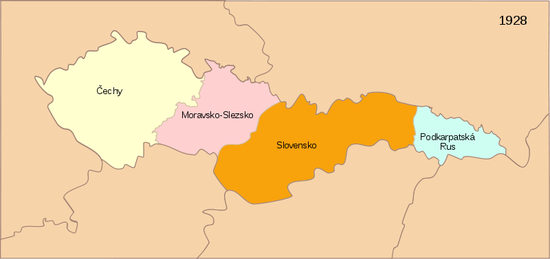
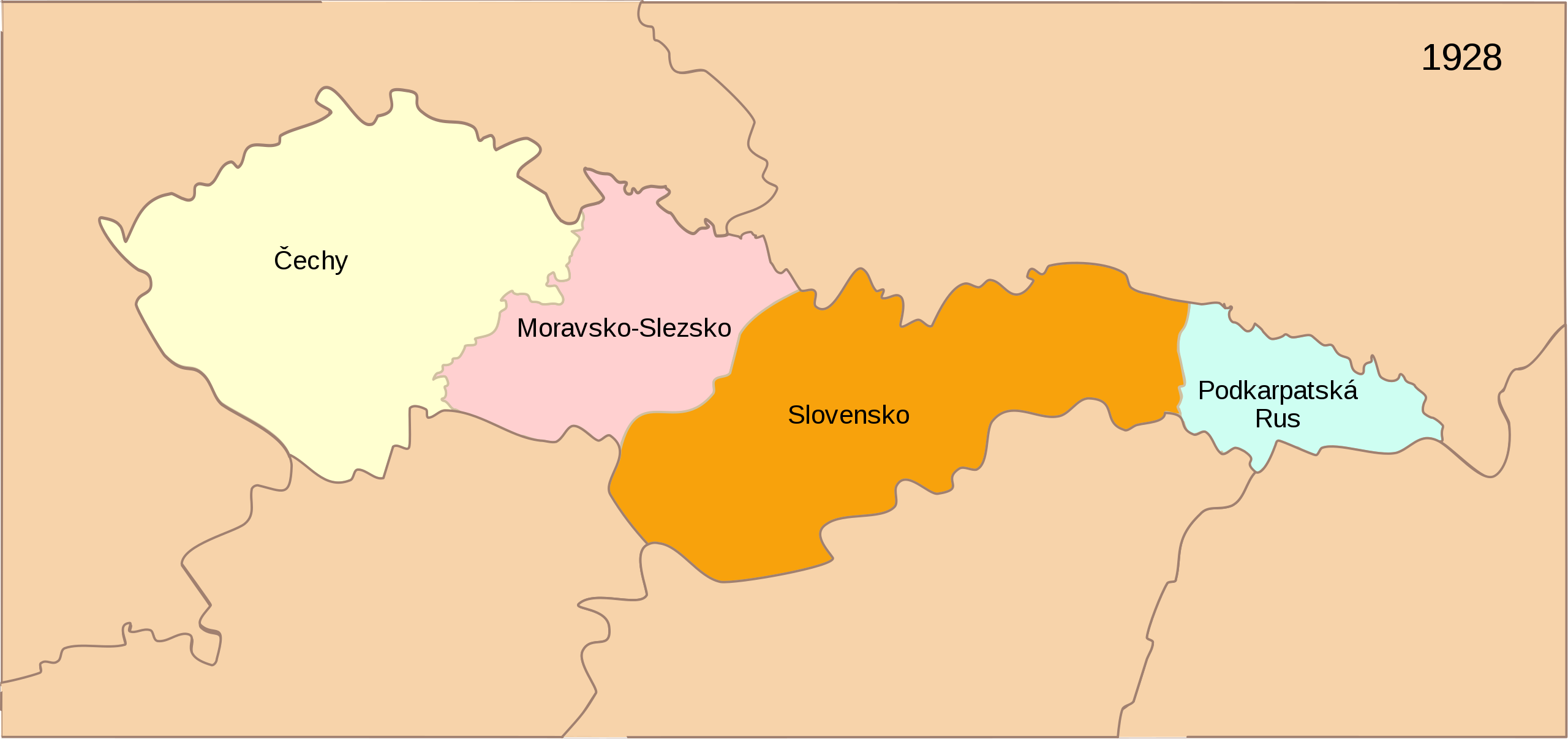
[] Deutsch: Karte der Tschechoslowakischen Republik (1928) English: Map of the First Czechoslovak Republic after 1928 Español: Mapa de la Primera República de Checoslovaquia tras los cambios de administración territorial de 1928 Français : Carte de la Première République tchécoslovaque aprés 1928 Magyar: Az első Csehszlovák Köztársaság 1928-ban Svenska: Karta över den första tjeckoslovakiska republiken efter 1928 Українська: Карта Першої Чехословацької Республіки після 1928 |
| Date | (UTC) |
| Source | |
| Author |
|
| Other versions |
[]
|


| This is a retouched picture, which means that it has been digitally altered from its original version. Modifications: French text. The original can be viewed here: First Czechoslovak Republic.SVG:
|
I, the copyright holder of this work, hereby publish it under the following license:
This file is licensed under the Creative Commons Attribution-Share Alike 3.0 Unported license.
- You are free:
- to share – to copy, distribute and transmit the work
- to remix – to adapt the work
- Under the following conditions:
- attribution – You must give appropriate credit, provide a link to the license, and indicate if changes were made. You may do so in any reasonable manner, but not in any way that suggests the licensor endorses you or your use.
- share alike – If you remix, transform, or build upon the material, you must distribute your contributions under the same or compatible license as the original.
Original upload log
This image is a derivative work of the following images:
- Image:First_Czechoslovak_Republic.SVG licensed with Cc-by-sa-3.0
- 2008-06-10T13:57:53Z Themightyquill 1001x472 (70691 Bytes)
- 2008-06-10T13:19:45Z Themightyquill 1001x471 (73985 Bytes)
- 2008-06-09T22:27:03Z Themightyquill 1001x471 (60585 Bytes)
- 2008-06-09T15:42:55Z Themightyquill 1001x471 (403234 Bytes)
- 2008-06-08T23:43:55Z Themightyquill 1001x471 (68801 Bytes)
- 2008-06-08T23:40:33Z Themightyquill 1100x497 (68914 Bytes) {{Information |Description={{fr|Carte vierge de l'Europe, couleurs Atelier Graphique}} {{en|Blank map of Europe with Atelier graphique colors}} |Source=*[[:Image:Czechoslovakia01.png|]] *[[:Image:Blank_map_of_Europe_-_Atelier
Uploaded with derivativeFX
File history
Click on a date/time to view the file as it appeared at that time.
| Date/Time | Thumbnail | Dimensions | User | Comment | |
|---|---|---|---|---|---|
| current | 21:22, 12 August 2008 | | 1,001 × 472 (68 KB) | Jackaranga | removing the black box |
| 19:56, 12 August 2008 |  | 1,001 × 472 (70 KB) | Themightyquill | {{Information |Description={{fr|Carte tchéque de la Première République tchécoslovaque aprés 1928}} {{en|Czech map of the First Czechoslovak Republic after 1928}} Category:Maps of Czechoslovakia |Source=*[[:Image:First_Czechoslovak_Republic.SVG| |
File usage
The following pages on the English Wikipedia use this file (pages on other projects are not listed):
Global file usage
The following other wikis use this file:
- Usage on cs.wikipedia.org
- Usage on ru.wikipedia.org
- Usage on sk.wikipedia.org
- Usage on sr.wikipedia.org