
File:Polish-Lithuanian Commonwealth in 1772.PNG
Size of this preview: 732 × 600 pixels. Other resolutions: 293 × 240 pixels | 586 × 480 pixels | 937 × 768 pixels | 1,250 × 1,024 pixels | 1,894 × 1,552 pixels.
Original file (1,894 × 1,552 pixels, file size: 747 KB, MIME type: image/png)
| This is a file from the Wikimedia Commons. Information from its description page there is shown below. Commons is a freely licensed media file repository. You can help. |
Summary
| Description |
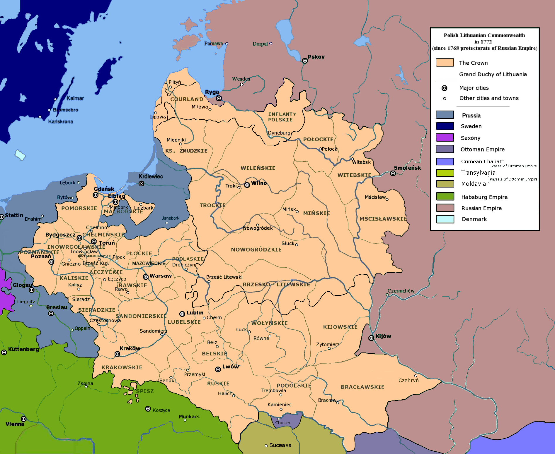
English: Polish-Lithuanian Commonwealth in 1772 |
| Date | |
| Source | Own work |
| Author | User:Mathiasrex Maciej Szczepańczyk, based on layers of User:Halibutt |
Licensing
I, the copyright holder of this work, hereby publish it under the following licenses:

|
Permission is granted to copy, distribute and/or modify this document under the terms of the GNU Free Documentation License, Version 1.2 or any later version published by the Free Software Foundation; with no Invariant Sections, no Front-Cover Texts, and no Back-Cover Texts. A copy of the license is included in the section entitled GNU Free Documentation License. |
This file is licensed under the Creative Commons Attribution-Share Alike 3.0 Unported license.
- You are free:
- to share – to copy, distribute and transmit the work
- to remix – to adapt the work
- Under the following conditions:
- attribution – You must give appropriate credit, provide a link to the license, and indicate if changes were made. You may do so in any reasonable manner, but not in any way that suggests the licensor endorses you or your use.
- share alike – If you remix, transform, or build upon the material, you must distribute your contributions under the same or compatible license as the original.
You may select the license of your choice.
File history
Click on a date/time to view the file as it appeared at that time.
| Date/Time | Thumbnail | Dimensions | User | Comment | |
|---|---|---|---|---|---|
| current | 09:35, 23 July 2020 | | 1,894 × 1,552 (747 KB) | Claude Zygiel | Tak: nie "województwa Kozackiego", a południe dobrze reprezentowane. :-) |
| 18:11, 18 June 2020 |  | 1,900 × 1,554 (735 KB) | Poznaniak | Reverted to version as of 05:53, 26 June 2018 (UTC) kuriozum, nie było żadnego województwa "kozackiego" | |
| 18:28, 13 April 2020 |  | 1,894 × 1,552 (751 KB) | Claude Zygiel | Some details since Stier, H.E. (ed.) ''Grosser Atlas zur Weltgeschichte'', Westermann 1985, {{ISBN|3-14-100919-8}}, ''Putzger historischer Weltatlas'', Cornelsen 1990, {{ISBN|3-464-00176-8}}, Sellier, A.J. (ed.) « Atlas des Peuples » -''Europe centrale'', 1992, {{ISBN|2-7071-2032-4}} La Découverte publ., {{ISBN|2-7071-2222-X}}, Unger, M. (ed.) ''Történelmi atlasz'', Hungarian academy 1991, {{ISBN|963-351-422-3}}. | |
| 05:53, 26 June 2018 |  | 1,900 × 1,554 (735 KB) | Mathiasrex | new version | |
| 05:51, 26 June 2018 |  | 1,900 × 1,554 (742 KB) | Mathiasrex | new version | |
| 04:59, 15 March 2018 |  | 1,900 × 1,554 (793 KB) | Poeticbent | Reverted to version as of 17:27, 4 May 2017 (UTC) - accessibility for people with color vision impairment | |
| 19:08, 12 March 2018 |  | 1,992 × 1,554 (797 KB) | Mathiasrex | Reverted to version as of 09:39, 1 February 2017 (UTC) light green as Russian protectorate | |
| 17:27, 4 May 2017 |  | 1,900 × 1,554 (793 KB) | Maproom | Removed Habsburg-green pixels from Poland. Renamed "Russia" to "Russian Empire" | |
| 15:33, 2 March 2017 |  | 1,902 × 1,554 (822 KB) | Poeticbent | en:Talk:Partitions of Poland - accessibility for people with color vision impairment | |
| 09:39, 1 February 2017 |  | 1,992 × 1,554 (797 KB) | Mathiasrex | Reverted to version as of 22:48, 3 November 2011 (UTC) |
File usage
The following pages on the English Wikipedia use this file (pages on other projects are not listed):
Global file usage
The following other wikis use this file:
- Usage on de.wikipedia.org
- Usage on el.wikipedia.org
- Usage on es.wikipedia.org
- Usage on fr.wikipedia.org
- Usage on ga.wikipedia.org
- Usage on it.wikipedia.org
- Usage on lt.wikipedia.org
- Usage on lt.wikibooks.org
- Usage on pl.wikipedia.org
- Usage on pl.wikivoyage.org
- Usage on pnb.wikipedia.org
- Usage on ro.wikipedia.org
- Usage on simple.wikipedia.org
- Usage on sk.wikipedia.org
- Usage on sr.wikipedia.org
- Usage on th.wikipedia.org
- Usage on tr.wikipedia.org
- Usage on uk.wikipedia.org
- Usage on ur.wikipedia.org
- Usage on vi.wikipedia.org