
File:Penang south Kedah heightmap ASTGTM2 N05E100 dem.png

Size of this preview: 600 × 600 pixels. Other resolutions: 240 × 240 pixels | 480 × 480 pixels | 768 × 768 pixels | 1,024 × 1,024 pixels | 2,048 × 2,048 pixels | 3,601 × 3,601 pixels.
Original file (3,601 × 3,601 pixels, file size: 8.41 MB, MIME type: image/png)
| This is a file from the Wikimedia Commons. Information from its description page there is shown below. Commons is a freely licensed media file repository. You can help. |
Summary
| Description |
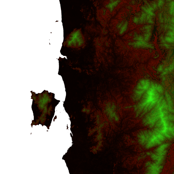
English: A heightmap of Penang state and the southern part of Kedah with contour discontinuities every 100 m, plotted from ASTER Global Digital Elevation Model data at http://step.esa.int/auxdata/dem/SRTMGL1 and coloured as follows:
|
| Source | Own work |
| Author | Cmglee |
| Other versions |
 |
Licensing
I, the copyright holder of this work, hereby publish it under the following licenses:
This file is licensed under the Creative Commons Attribution-Share Alike 3.0 Unported license.
- You are free:
- to share – to copy, distribute and transmit the work
- to remix – to adapt the work
- Under the following conditions:
- attribution – You must give appropriate credit, provide a link to the license, and indicate if changes were made. You may do so in any reasonable manner, but not in any way that suggests the licensor endorses you or your use.
- share alike – If you remix, transform, or build upon the material, you must distribute your contributions under the same or compatible license as the original.

|
Permission is granted to copy, distribute and/or modify this document under the terms of the GNU Free Documentation License, Version 1.2 or any later version published by the Free Software Foundation; with no Invariant Sections, no Front-Cover Texts, and no Back-Cover Texts. A copy of the license is included in the section entitled GNU Free Documentation License. |
You may select the license of your choice.
File history
Click on a date/time to view the file as it appeared at that time.
| Date/Time | Thumbnail | Dimensions | User | Comment | |
|---|---|---|---|---|---|
| current | 18:59, 29 October 2013 | | 3,601 × 3,601 (8.41 MB) | Cmglee | {{Information |Description ={{en|1=A heightmap of Penang state and the southern part of Kedah with contour discontinuities every 100 m, plotted from ASTER Global Digital Elevation Model data at http://gdem.ersdac.jspacesystems.or.jp/download.jsp and... |
File usage
The following pages on the English Wikipedia use this file (pages on other projects are not listed):
Global file usage
The following other wikis use this file:
- Usage on ceb.wikipedia.org
- Usage on fa.wikipedia.org
- Usage on it.wikivoyage.org
- Usage on lld.wikipedia.org
- Usage on ta.wikipedia.org
- Usage on www.wikidata.org