
File:Okehocking HD Chesco PA.JPG

Size of this preview: 800 × 600 pixels. Other resolutions: 320 × 240 pixels | 640 × 480 pixels | 1,024 × 768 pixels | 1,280 × 960 pixels | 2,204 × 1,653 pixels.
Original file (2,204 × 1,653 pixels, file size: 2.2 MB, MIME type: image/jpeg)
| This is a file from the Wikimedia Commons. Information from its description page there is shown below. Commons is a freely licensed media file repository. You can help. |
|
This is an image of a place or building that is listed on the National Register of Historic Places in the United States of America. Its reference number is 93000719. |
Summary
| Description |
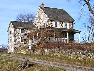
English: House in Okehocking Historic District on the NRHP since August 2, 1993. The HD is roughly bounded by West Chester Pike (S), Plumsock Road (E), Goshen Road (N), and Garrett Mill Road (W), about 6 miles east of West Chester, PA and a few miles NW of Ridley Creek Park, in Chester County, PA near the border with Delaware County. In 1703 500 acres was deeded by William Penn to the Okehocking band of Lennape (Delaware) Indians. They left before 1740 and land was settled by Quakers at that time. Very agricultural area with conservation easements and a township park, Quaker meeting house, Gentlemen Farmers' houses. This house is just off West Chester Pike (PA 3) near center from east to west. Willistown Township |
| Date | |
| Source | Own work |
| Author | Smallbones |
| Camera location | | View this and other nearby images on: OpenStreetMap |
|---|
Licensing
| I, the copyright holder of this work, release this work into the public domain. This applies worldwide. In some countries this may not be legally possible; if so: I grant anyone the right to use this work for any purpose, without any conditions, unless such conditions are required by law. |
File history
Click on a date/time to view the file as it appeared at that time.
| Date/Time | Thumbnail | Dimensions | User | Comment | |
|---|---|---|---|---|---|
| current | 01:46, 24 December 2010 | | 2,204 × 1,653 (2.2 MB) | Smallbones | {{Information |Description={{en|1=House in Okehocking Historic District on the NRHP since August 2, 1993. The HD is roughly bounded by West Chester Pike (S), Plumsock Road (E), Goshen Road (N), and Garrett Mill Road (W), about 6 miles east of West Chester |
File usage
The following pages on the English Wikipedia use this file (pages on other projects are not listed):
Global file usage
The following other wikis use this file:
- Usage on fr.wikipedia.org
- Usage on tl.wikipedia.org
- Usage on uk.wikipedia.org
- Usage on www.wikidata.org