
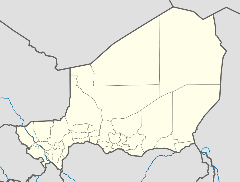
File:Niger location map.svg

Size of this PNG preview of this SVG file: 792 × 600 pixels. Other resolutions: 317 × 240 pixels | 634 × 480 pixels | 1,014 × 768 pixels | 1,280 × 970 pixels | 2,560 × 1,939 pixels | 1,006 × 762 pixels.
Original file (SVG file, nominally 1,006 × 762 pixels, file size: 101 KB)
| This is a file from the Wikimedia Commons. Information from its description page there is shown below. Commons is a freely licensed media file repository. You can help. |
Summary
| Description |
Deutsch: Positionskarte von Niger
Quadratische Plattkarte, N-S-Streckung. Geographische Begrenzung der Karte:
English: Location map of Niger
Equirectangular projection, N/S stretching. Geographic limits of the map:
|
| Date | |
| Source |
Own work, using
|
| Author | Carport |
| Other versions |
|
| SVG development | This W3C-invalid map was created with Adobe Illustrator. |

Licensing
This file is licensed under the Creative Commons Attribution-Share Alike 2.0 Generic license.
- You are free:
- to share – to copy, distribute and transmit the work
- to remix – to adapt the work
- Under the following conditions:
- attribution – You must give appropriate credit, provide a link to the license, and indicate if changes were made. You may do so in any reasonable manner, but not in any way that suggests the licensor endorses you or your use.
- share alike – If you remix, transform, or build upon the material, you must distribute your contributions under the same or compatible license as the original.
File history
Click on a date/time to view the file as it appeared at that time.
| Date/Time | Thumbnail | Dimensions | User | Comment | |
|---|---|---|---|---|---|
| current | 09:52, 6 December 2011 | | 1,006 × 762 (101 KB) | NordNordWest | cleanup |
| 13:02, 10 February 2010 |  | 1,006 × 762 (435 KB) | Carport | {{Information |Description={{de|1=Positionskarte von {{w|Niger|3=de}} {{w|Quadratische Plattkarte|3=de}}, N-S-Streckung. Geographische Begrenzung der Karte: * N: 24° N * S: 11° N * W: 1° W * O: 17° O}} {{en|1=Location map of {{w|Niger}} Equirectangu |
File usage
More than 100 pages use this file. The following list shows the first 100 pages that use this file only. A full list is available.
- Abala, Niger
- Abalak
- Aderbissinat
- Afassa
- Aguelal
- Aguie
- Aouderas
- Arlit Airport
- Assamakka
- Assarara
- Ayourou
- Bande, Niger
- Bani-Bangou
- Bankilare
- Bilma
- Birni-N'Konni
- Birni N'Gaouré
- Bosso, Niger
- Bouza
- Chetimari
- Dabaga, Niger
- Dannet
- Diagorou
- Diffa
- Diffa Airport
- Diori Hamani International Airport
- Dirkou
- Dirkou Airport
- Dogondoutchi
- Dogondoutchi Airport
- Dosso, Niger
- Dosso Reserve
- Doungou
- Elok
- Fabidji
- Fachi
- Filingué
- Galmi
- Garhanga
- Gaya Airport (Niger)
- Goudoumaria
- Gouna
- Goure
- Goûgaram
- Gueskerou
- Guidan Amoumoune
- Guidiguir
- Hamdallaye, Niger
- Harikanassou
- I-n-Azaoua
- Iferouane Airport
- In-Gall
- Inignaouei
- Jikata, Niger
- Kantche
- Karma, Niger
- Keita, Niger
- Kelakam, Niger
- Kokorou
- Kornaka
- Koré Maïroua
- La Tapoa
- Madaoua
- Magaria
- Mainé-Soroa
- Malbaza
- Maradi, Niger
- Maradi Airport
- Marendet
- Mirriah
- N'Guelbély
- N'guigmi
- Ouallam Airport
- Oubandawaki Makiani
- Ourafane
- Ourofan
- Samira Hill Gold Mine
- Say, Niger
- Sidaouet
- Séguedine
- Taggafadi
- Tahoua
- Tahoua Airport
- Takedda
- Takieta
- Tanout
- Tarhmert
- Tchintabaraden
- Tchintoulous
- Tchirozerine
- Teouat
- Termit Massif Reserve
- Tessaoua
- Tibiri
- Tillabéri Airport
- Timia
- Tree of Ténéré
- Téra
- UTA Flight 772
- Zinder
View more links to this file.
Global file usage
The following other wikis use this file:
- Usage on af.wikipedia.org
- Usage on am.wikipedia.org
- Usage on an.wikipedia.org
- Usage on ar.wikipedia.org
- Usage on ast.wikipedia.org
- Usage on azb.wikipedia.org
- Usage on az.wikipedia.org
- Usage on ba.wikipedia.org
- Usage on be-tarask.wikipedia.org
- Usage on be.wikipedia.org
- Usage on bg.wikipedia.org
- Usage on bn.wikipedia.org
- Usage on br.wikipedia.org
- Usage on bs.wikipedia.org
- Usage on ca.wikipedia.org
- Usage on ceb.wikipedia.org
View more global usage of this file.