
File:New Orleans USACE-17th Canal-A-09-04-05 0004.JPG

Original file (3,008 × 2,000 pixels, file size: 1.49 MB, MIME type: image/jpeg)
| This is a file from the Wikimedia Commons. Information from its description page there is shown below. Commons is a freely licensed media file repository. You can help. |
Summary
New Orleans after Hurricane Katrina:
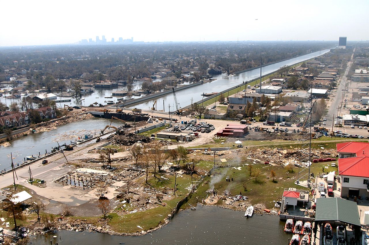
The 17th Street Canal stretches southward, the boundry between Jefferson and Orleans Parishes in Louisiana. This aerial photo was taken Sunday, September 4, 2005. The bridge in the foreground (The Old Hammond Highway Bridge, undergoing a rebuilding before the storm) enabled Army Corps of Engineers contracts to drive sheet piling to close off the canal from Lake Ponchartrain. The Lake Pontchartrain end of the Canal is just over block distant off the lower left edge of the photo. Looking down the canal the breach into Orleans Parish is visible. The skyline of the New Orleans Central Business District lies in the distance. In the front center left, the pilings are all that remain of locally famous Sid-Mar's Seafood Restaurant, destroyed by the storm. (U.S. Army Corps of Engineers photo by Alan Dooley)
http://www.usace.army.mil/katrina-images/NO-A-09-04-05_0004.JPG
Related images include
-
 Blackhawk helicopter delivering sandbag. Pattern of sandbags is similar to this image.
 -
 Sheet pile material.


Licensing
This file is a work of a U.S. Army soldier or employee, taken or made as part of that person's official duties. As a work of the U.S. federal government, it is in the public domain in the United States.
|
 |
File history
Click on a date/time to view the file as it appeared at that time.
| Date/Time | Thumbnail | Dimensions | User | Comment | |
|---|---|---|---|---|---|
| current | 09:23, 9 September 2005 | | 3,008 × 2,000 (1.49 MB) | SEWilco | The 17th Street Canal stretches southward between Jefferson and Orleans Parishes in this aerial photo taken Sunday, September 4. The uncompleted bridge in the foreground enabled Corps of Engineers contracts to drive sheet piling to close off the canal fr |
File usage
Global file usage
The following other wikis use this file:
- Usage on en.wikinews.org
- Usage on es.wikipedia.org
- Usage on it.wikinews.org
- Usage on ja.wikipedia.org