
File:NO 0616 Nes.svg

Size of this PNG preview of this SVG file: 513 × 600 pixels. Other resolutions: 205 × 240 pixels | 411 × 480 pixels | 657 × 768 pixels | 876 × 1,024 pixels | 1,752 × 2,048 pixels | 551 × 644 pixels.
Original file (SVG file, nominally 551 × 644 pixels, file size: 59 KB)
| This is a file from the Wikimedia Commons. Information from its description page there is shown below. Commons is a freely licensed media file repository. You can help. |
| Description |
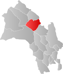
Norsk bokmål: Kart som viser Buskerud' plassering innen [[:no: {{{2}}}| {{{2}}}]], laga av Jon Harald Søby.
English: Map showing the position of Buskerud within [[:w: {{{2}}}| {{{2}}}]], made by Jon Harald Søby.
Svenska: Karta som visar Buskerud kommuns läge i [[:Category:{{{2}}}|{{{2}}}]] fylke, skapad av Jon Harald Søby. |
||
| Date | |||
| Source | Own work | ||
| Author | Jon Harald Søby | ||
| Permission (Reusing this file) |
|
||
| SVG development |
[[Category:Locator maps of {{{2}}}]]
File history
Click on a date/time to view the file as it appeared at that time.
| Date/Time | Thumbnail | Dimensions | User | Comment | |
|---|---|---|---|---|---|
| current | 21:01, 21 January 2007 | | 551 × 644 (59 KB) | Jon Harald Søby | {{User:Jon Harald Søby/Kartlisens|Nes|Oppland|s=ja}} |
File usage
The following pages on the English Wikipedia use this file (pages on other projects are not listed):
Global file usage
The following other wikis use this file:
- Usage on ar.wikipedia.org
- Usage on bpy.wikipedia.org
- Usage on ca.wikipedia.org
- Usage on es.wikipedia.org
- Usage on fa.wikipedia.org
- Usage on fr.wikipedia.org
- Usage on hu.wikipedia.org
- Usage on hy.wikipedia.org
- Usage on ka.wikipedia.org
- Usage on ko.wikipedia.org
- Usage on la.wikipedia.org
- Usage on li.wikipedia.org
- Usage on nds.wikipedia.org
- Usage on no.wikipedia.org
- Usage on pl.wikipedia.org
- Usage on pnb.wikipedia.org
- Usage on ro.wikipedia.org
- Usage on ru.wikipedia.org
- Usage on se.wikipedia.org
- Usage on sl.wikipedia.org
- Usage on sq.wikipedia.org
- Usage on th.wikipedia.org
- Usage on tr.wikipedia.org
- Usage on ur.wikipedia.org
- Usage on vi.wikipedia.org