
File:Mughal1700.png
Size of this preview: 800 × 467 pixels. Other resolutions: 320 × 187 pixels | 640 × 374 pixels | 1,284 × 750 pixels.
Original file (1,284 × 750 pixels, file size: 36 KB, MIME type: image/png)
| This is a file from the Wikimedia Commons. Information from its description page there is shown below. Commons is a freely licensed media file repository. You can help. |
Being a Ruler is a tough thing with such a vast empire
Summary
| Description |
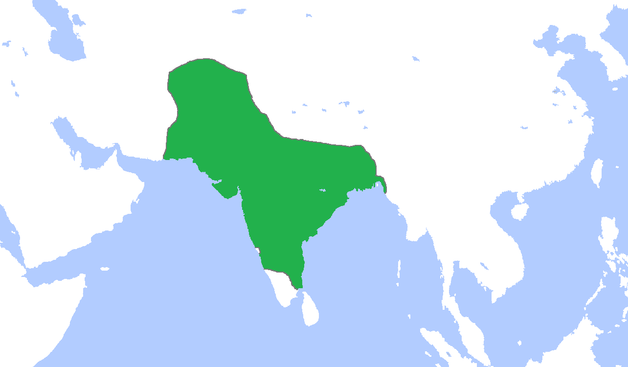
English: Locator map of the Mughal Empire, c. 1700.
(Partially based on Atlas of World History (2007) - The World 1600-1700, map) |
| Date | |
| Source | Own work |
| Author | Gabagool |

|
File:MughalEmpire1700.svg is a vector version of this file. It should be used in place of this PNG file when not inferior.
File:Mughal1700.png → File:MughalEmpire1700.svg
For more information, see Help:SVG. |
 |
Licensing
I, the copyright holder of this work, hereby publish it under the following license:
This file is licensed under the Creative Commons Attribution 3.0 Unported license.
- You are free:
- to share – to copy, distribute and transmit the work
- to remix – to adapt the work
- Under the following conditions:
- attribution – You must give appropriate credit, provide a link to the license, and indicate if changes were made. You may do so in any reasonable manner, but not in any way that suggests the licensor endorses you or your use.
File history
Click on a date/time to view the file as it appeared at that time.
| Date/Time | Thumbnail | Dimensions | User | Comment | |
|---|---|---|---|---|---|
| current | 16:44, 5 November 2009 | | 1,284 × 750 (36 KB) | Gabagool | {{Information |Description={{en|1=Locator map of the Mughal Empire, c. 1700. (Partially based on ''Atlas of World History'' (2007) - The World 1600-1700, map)}} |Source={{own}} |Author=Gabagool / Jarle Grøhn |Date=2009-11-05 |Permissio |
File usage
The following pages on the English Wikipedia use this file (pages on other projects are not listed):
Global file usage
The following other wikis use this file:
- Usage on ar.wikipedia.org
- Usage on azb.wikipedia.org
- Usage on bn.wikipedia.org
- Usage on bs.wikipedia.org
- Usage on crh.wikipedia.org
- Usage on cs.wikipedia.org
- Usage on cy.wikipedia.org
- Usage on da.wikipedia.org
- Usage on el.wikipedia.org
- Usage on es.wikipedia.org
- Usage on et.wikipedia.org
- Usage on fa.wikipedia.org
- Usage on fi.wikipedia.org
- Usage on gu.wikipedia.org
- Usage on hi.wikipedia.org
- Usage on hu.wikipedia.org
- Usage on id.wikipedia.org
- Usage on id.wikibooks.org
- Usage on it.wikipedia.org
- Usage on ja.wikipedia.org
- Usage on ka.wikipedia.org
- Usage on kk.wikipedia.org
- Usage on ko.wikipedia.org
- Usage on lt.wikipedia.org
- Usage on lv.wikipedia.org
- Usage on ml.wikipedia.org
View more global usage of this file.