
File:Moss Hall near Audlem, Cheshire - geograph.org.uk - 1601087.jpg
No higher resolution available.
Moss_Hall_near_Audlem,_Cheshire_-_geograph.org.uk_-_1601087.jpg (640 × 479 pixels, file size: 130 KB, MIME type: image/jpeg)
| This is a file from the Wikimedia Commons. Information from its description page there is shown below. Commons is a freely licensed media file repository. You can help. |
Summary
| Description |
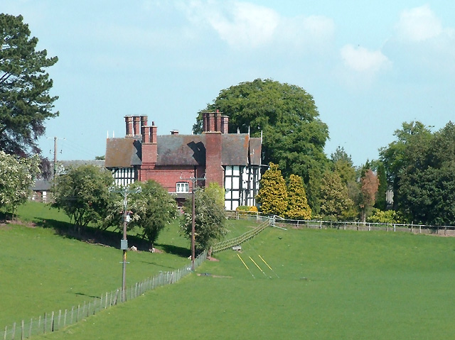
English: Moss Hall near Audlem, Cheshire A telephoto view looking across the grass fields from the canal towpath. The house is about four hundred metres from the camera position.
Moss Hall is a Grade I listed manor house. The building dates from 1616 and it was extensively renovated in 1902. |
| Date | |
| Source | From geograph.org.uk |
| Author | Roger Kidd |
| Attribution (required by the license) | Roger Kidd / Moss Hall near Audlem, Cheshire / |
This is a photo of listed building number 1138519. |
| Camera location | | View this and other nearby images on: OpenStreetMap |
|---|
_heading:337.00&language=en)
| Object location | | View this and other nearby images on: OpenStreetMap |
|---|
_heading:337.00&language=en)
Licensing

|
This image was taken from the Geograph project collection. See this photograph's page on the Geograph website for the photographer's contact details. The copyright on this image is owned by Roger Kidd and is licensed for reuse under the Creative Commons Attribution-ShareAlike 2.0 license.
|
This file is licensed under the Creative Commons Attribution-Share Alike 2.0 Generic license.
Attribution: Roger Kidd
- You are free:
- to share – to copy, distribute and transmit the work
- to remix – to adapt the work
- Under the following conditions:
- attribution – You must give appropriate credit, provide a link to the license, and indicate if changes were made. You may do so in any reasonable manner, but not in any way that suggests the licensor endorses you or your use.
- share alike – If you remix, transform, or build upon the material, you must distribute your contributions under the same or compatible license as the original.
File history
Click on a date/time to view the file as it appeared at that time.
| Date/Time | Thumbnail | Dimensions | User | Comment | |
|---|---|---|---|---|---|
| current | 06:55, 4 March 2011 | | 640 × 479 (130 KB) | GeographBot | == {{int:filedesc}} == {{Information |description={{en|1=Moss Hall near Audlem, Cheshire A telephoto view looking across the grass fields from the canal towpath. The house is about four hundred metres from the camera position. Moss Hall is a Grade I li |
File usage
The following pages on the English Wikipedia use this file (pages on other projects are not listed):