
File:Mosport.svg

Size of this PNG preview of this SVG file: 800 × 554 pixels. Other resolutions: 320 × 221 pixels | 640 × 443 pixels | 1,024 × 709 pixels | 1,280 × 886 pixels | 2,560 × 1,772 pixels | 1,341 × 928 pixels.
Original file (SVG file, nominally 1,341 × 928 pixels, file size: 36 KB)
| This is a file from the Wikimedia Commons. Information from its description page there is shown below. Commons is a freely licensed media file repository. You can help. |
Summary
| Description |
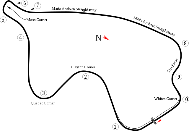
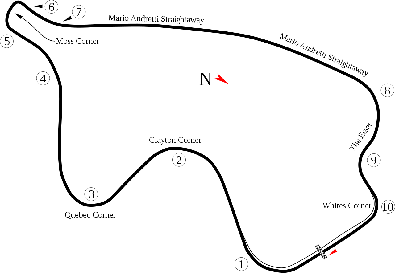
English: Track map for Mosport International Raceway |
| Date | |
| Source | Own work |
| Author | Will Pittenger |
| Other versions |
|

| Camera location | | View this and other nearby images on: OpenStreetMap |
|---|
Licensing
| I, the copyright holder of this work, release this work into the public domain. This applies worldwide. In some countries this may not be legally possible; if so: I grant anyone the right to use this work for any purpose, without any conditions, unless such conditions are required by law. |
File history
Click on a date/time to view the file as it appeared at that time.
| Date/Time | Thumbnail | Dimensions | User | Comment | |
|---|---|---|---|---|---|
| current | 05:28, 20 July 2008 | | 1,341 × 928 (36 KB) | Will Pittenger | New version adds name that I didn't see before. |
| 05:14, 20 July 2008 |  | 1,341 × 928 (36 KB) | Will Pittenger | {{Information |Description={{en|1=Track map for w:Mosport International Raceway}} |Source=Own work by uploader |Author=Will Pittenger |Date=7-20-2008 |Permission= |other_versions=<gallery>Image:Circuit Mostport Park.png|Old ve |
File usage
The following pages on the English Wikipedia use this file (pages on other projects are not listed):
- 1961 Canadian Grand Prix
- 1966 Canadian Grand Prix
- 1967 Canadian Grand Prix
- 1967 Canadian motorcycle Grand Prix
- 1969 Canadian Grand Prix
- 1971 Canadian Grand Prix
- 1972 Canadian Grand Prix
- 1973 Canadian Grand Prix
- 1974 Canadian Grand Prix
- 1976 Canadian Grand Prix
- 1977 Canadian Grand Prix
- 1984 1000 km of Mosport
- 1985 1000 km of Mosport
- 1997 Mosport Festival
- 1998 Mosport Festival
- 1999 Grand Prix of Mosport
- 2000 Grand Prix of Mosport
- 2001 Grand Prix of Mosport
- 2002 Grand Prix of Mosport
- 2003 Grand Prix of Mosport
- 2004 Grand Prix of Mosport
- 2005 Grand Prix of Mosport
- 2006 Grand Prix of Mosport
- 2007 Grand Prix of Mosport
- 2008 Grand Prix of Mosport
- 2009 Grand Prix of Mosport
- 2010 Grand Prix of Mosport
- 2011 Grand Prix of Mosport
- 2012 Grand Prix of Mosport
- 2013 Chevrolet Silverado 250
- 2013 SportsCar Grand Prix
- 2014 SportsCar Grand Prix
- 2015 SportsCar Grand Prix
- 2016 SportsCar Grand Prix
- 2017 Mobil 1 SportsCar Grand Prix
- 2018 SportsCar Grand Prix
- 2019 Mobil 1 SportsCar Grand Prix
- 2022 Chevrolet Grand Prix
- 2023 Chevrolet Grand Prix
- Canadian Touring Car Championship
- Chevrolet Grand Prix
- Chevrolet Silverado 250
- Clarington 200
- List of American Le Mans Series circuits
- List of Can-Am Challenge Cup circuits
- List of Formula One circuits
- List of GT World Challenge America circuits
- List of Grand Prix motorcycle circuits
- List of IMSA GT Championship circuits
- List of IMSA SportsCar Championship circuits
- List of Superbike World Championship circuits
- List of World Sportscar Championship circuits
- List of auto racing tracks in Canada
- Mosport Can-Am
- Mosport Trans-Am
- User:CplDHicks2/2017 SportsCar Grand Prix
- User talk:4u1e/archive5
- User talk:Bam123456789/Archive 1
- User talk:Barkjon/Archive 2
- User talk:Cdhaptomos/Archive 1
- User talk:Chubbennaitor/Archive7
- User talk:Chubbennaitor/archive2
- User talk:Clyde1998/Archive/2008
- User talk:Cs-wolves/Archive 3
- User talk:Donnie Park/Archive 1
- User talk:Hellboy2hell/archive2
- User talk:Midgrid/Archive 6
- User talk:NapHit/Archive 1
- User talk:Readro/Archive 3
- User talk:Sage Callahan/Archive 1
- User talk:Spenalzo/Archive/2008
- User talk:The359/Archive 4
- User talk:Thelb4/Archive 5
- User talk:Typ932/Archive 3
- Wikipedia:WikiProject Formula One/Newsletter/200808
Global file usage
The following other wikis use this file:
- Usage on af.wikipedia.org
- Usage on ar.wikipedia.org
- Usage on ast.wikipedia.org
- Usage on bg.wikipedia.org
- Usage on bn.wikipedia.org
- Usage on ca.wikipedia.org
- Usage on cs.wikipedia.org
- Usage on de.wikipedia.org
- Usage on es.wikipedia.org
- Anexo:Gran Premio de Canadá de 1977
- Anexo:Gran Premio de Canadá de 1976
- Anexo:Gran Premio de Canadá de 1974
- Anexo:Gran Premio de Canadá de 1973
- Anexo:Gran Premio de Canadá de 1969
- Anexo:Gran Premio de Canadá de 1967
- Anexo:Gran Premio de Canadá de 1972
- Anexo:Gran Premio de Canadá de 1971
- Anexo:Grandes Premios de Fórmula 1
- Anexo:Circuitos de Fórmula 1
- Canadian Tire Motorsport Park
- Usage on et.wikipedia.org
- Usage on eu.wikipedia.org
- Usage on fa.wikipedia.org
View more global usage of this file.