
File:Metro e ferrovie roma.svg

Size of this PNG preview of this SVG file: 633 × 599 pixels. Other resolutions: 253 × 240 pixels | 507 × 480 pixels | 811 × 768 pixels | 1,081 × 1,024 pixels | 2,163 × 2,048 pixels | 924 × 875 pixels.
Original file (SVG file, nominally 924 × 875 pixels, file size: 411 KB)
| This is a file from the Wikimedia Commons. Information from its description page there is shown below. Commons is a freely licensed media file repository. You can help. |
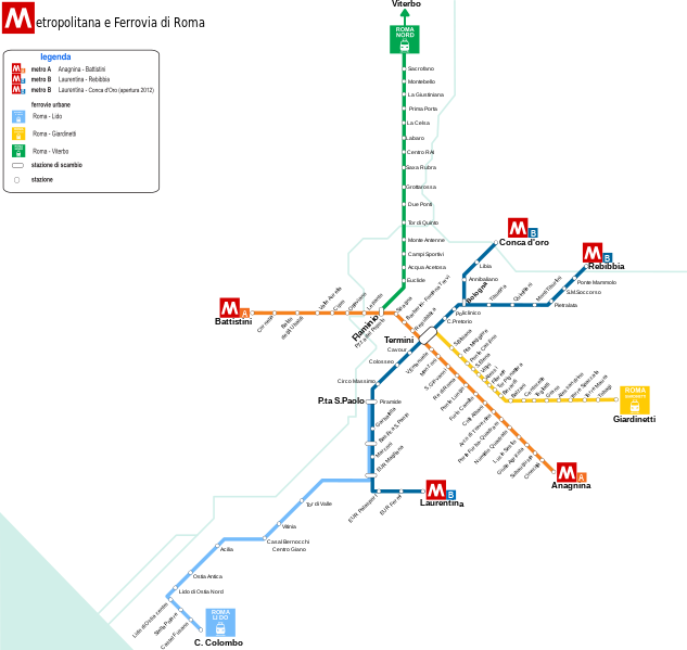
| Description | Mappa della Metropolitana di Roma e delle ferrovie suburbane |
| Date | 10/01/2010 |
| Source | File:Metroroma02.png |
| Author | Gigillo83 |
| I, the copyright holder of this work, release this work into the public domain. This applies worldwide. In some countries this may not be legally possible; if so: I grant anyone the right to use this work for any purpose, without any conditions, unless such conditions are required by law. |
This W3C-unspecified vector image was created with Inkscape .
File history
Click on a date/time to view the file as it appeared at that time.
| Date/Time | Thumbnail | Dimensions | User | Comment | |
|---|---|---|---|---|---|
| current | 16:08, 10 February 2012 | | 924 × 875 (411 KB) | Barlemi74 | |
| 18:06, 16 February 2010 |  | 924 × 875 (361 KB) | Barlemi74 | Modifica della linea Roma - Giardinetti, della Roma - Viterbo come Roma Nord e l'aggiunta dei fiumi Aniene e Tevere | |
| 08:02, 12 January 2010 |  | 736 × 839 (983 KB) | Gigillo83 | Unione Laziali e termini | |
| 13:28, 10 January 2010 |  | 736 × 839 (977 KB) | Gigillo83 | {{Information |Description=Mappa della Metropolitana di Roma e delle ferrovie suburbane |Source=File:Metroroma02.png |Date=10/01/2010 |Author=Gigillo83 |other_versions= |Permission= }} {{PD-self}} [[Category:Rapid transit maps of R |
File usage
The following pages on the English Wikipedia use this file (pages on other projects are not listed):
Global file usage
The following other wikis use this file:
- Usage on fr.wikipedia.org
- Usage on it.wikipedia.org
- Usage on ja.wikipedia.org
- Usage on ku.wikipedia.org
- Usage on roa-tara.wikipedia.org