
File:Mediaeval universities.jpg
Size of this preview: 685 × 599 pixels. Other resolutions: 274 × 240 pixels | 549 × 480 pixels | 878 × 768 pixels | 1,127 × 986 pixels.
Original file (1,127 × 986 pixels, file size: 1.17 MB, MIME type: image/jpeg)
| This is a file from the Wikimedia Commons. Information from its description page there is shown below. Commons is a freely licensed media file repository. You can help. |
Summary
| Description |
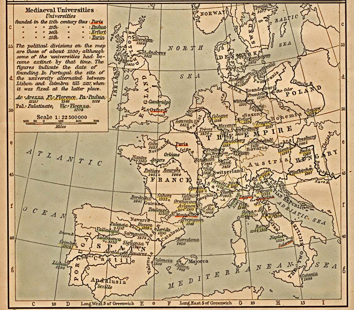
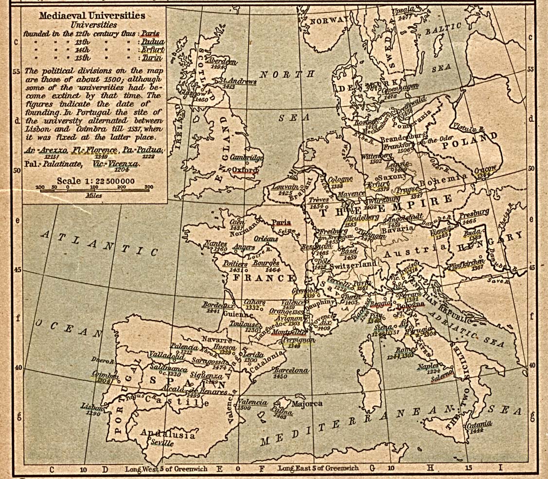
English: Scan from "Historical Atlas" by William R. Shepherd, New York, Henry Holt and Company, 1923. |
||||||||||||||||||||||
| Date | (the same map was included on a half-page in the 1911 edition) | ||||||||||||||||||||||
| Source | |||||||||||||||||||||||
| Author |
|
||||||||||||||||||||||
| Permission (Reusing this file) |
From the FAQ @ http://www.lib.utexas.edu/maps/faq.html
|
||||||||||||||||||||||
| Other versions | العربيَّة | ||||||||||||||||||||||
Licensing
This work is in the public domain in the United States because it was published (or registered with the U.S. Copyright Office) before January 1, 1929.
Public domain works must be out of copyright in both the United States and in the source country of the work in order to be hosted on the Commons. If the work is not a U.S. work, the file must have an additional copyright tag indicating the copyright status in the source country.
Note: This tag should not be used for sound recordings. |
Original upload log
Transferred from en.wikipedia to Commons by SreeBot.
The original description page was here. All following user names refer to en.wikipedia.
Upload date | User | Bytes | Dimensions | Comment
- 2006-12-18 21:40 (UTC) | Jengod | 361656 (bytes) | 1127×986 | {{PD}} Scan from "Historical Atlas" by William R. Shepherd, New York, Henry Holt and Company, 1923. Original image at the [http://www.lib.utexas.edu/maps/ Perry-Castañeda Library Map Collection] at the [[University of Texas at Austin]] website: http:/
File history
Click on a date/time to view the file as it appeared at that time.
| Date/Time | Thumbnail | Dimensions | User | Comment | |
|---|---|---|---|---|---|
| current | 16:31, 30 July 2012 | | 1,127 × 986 (1.17 MB) | SteveMcCluskey | Improved legibility by reducing extraneous background detail, increasing contrast of image, and enhancing color saturation of underlining. |
| 18:38, 20 September 2011 |  | 1,127 × 986 (353 KB) | SreeBot | (Original text) : {{PD}} Scan from "Historical Atlas" by William R. Shepherd, New York, Henry Holt and Company, 1923. Original image at the [http://www.lib.utexas.edu/maps/ Perry-Castañeda Library Map Collection] at the [[University of Texas at Austin |
File usage
The following pages on the English Wikipedia use this file (pages on other projects are not listed):
Global file usage
The following other wikis use this file:
- Usage on ast.wikipedia.org
- Usage on azb.wikipedia.org
- Usage on az.wikipedia.org
- Usage on ca.wikipedia.org
- Usage on cs.wikipedia.org
- Usage on es.wikipedia.org
- Usage on fr.wikipedia.org
- Usage on id.wikipedia.org
- Usage on ja.wikipedia.org
- Usage on ka.wikipedia.org
- Usage on pt.wikipedia.org
- Usage on sq.wikipedia.org
- Usage on uk.wikipedia.org
- Usage on uz.wikipedia.org
- Usage on www.wikidata.org