
File:Marincellomap.jpg

Size of this preview: 800 × 530 pixels. Other resolutions: 320 × 212 pixels | 640 × 424 pixels | 1,024 × 679 pixels | 1,280 × 849 pixels | 2,000 × 1,326 pixels.
Original file (2,000 × 1,326 pixels, file size: 594 KB, MIME type: image/jpeg)
| This is a file from the Wikimedia Commons. Information from its description page there is shown below. Commons is a freely licensed media file repository. You can help. |
Summary
| Description |
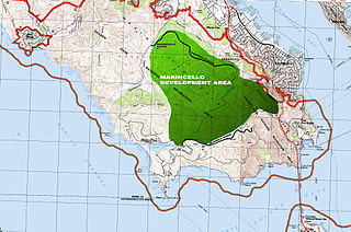
English: The green area represents the 2,000 acres of land that was to be developed as the Marincello city. Right next to where the word AREA is written is one of the highest points of the Marin Headlands- this is where the landmark hotel would have been built. Marincello Blvd. is now the Marincello Trail. This was created on a USGS map which is public domain, and was acquired on this website: http://libremap.org/ |
| Source | Wikipedia |
| Author | Sportsfan919 |
Licensing
I, the copyright holder of this work, hereby publish it under the following licenses:

|
Permission is granted to copy, distribute and/or modify this document under the terms of the GNU Free Documentation License, Version 1.2 or any later version published by the Free Software Foundation; with no Invariant Sections, no Front-Cover Texts, and no Back-Cover Texts. A copy of the license is included in the section entitled GNU Free Documentation License. |
This file is licensed under the Creative Commons Attribution 3.0 Unported license.
- You are free:
- to share – to copy, distribute and transmit the work
- to remix – to adapt the work
- Under the following conditions:
- attribution – You must give appropriate credit, provide a link to the license, and indicate if changes were made. You may do so in any reasonable manner, but not in any way that suggests the licensor endorses you or your use.
You may select the license of your choice.
File history
Click on a date/time to view the file as it appeared at that time.
| Date/Time | Thumbnail | Dimensions | User | Comment | |
|---|---|---|---|---|---|
| current | 19:00, 30 August 2013 | | 2,000 × 1,326 (594 KB) | DimiTalen | {{Information |Description ={{en|1=The boulevard that was build in 1965 to be the main entrance in and out of Marincello, today exists as a dirt road for hikers called the "Marincello Trail". This is at the base of the trail, right behind where the ... |
File usage
The following pages on the English Wikipedia use this file (pages on other projects are not listed):
Global file usage
The following other wikis use this file:
- Usage on nl.wikipedia.org
- Usage on www.wikidata.org