
File:Map of the portuguese and spanish railways.jpg
Original file (2,313 × 1,821 pixels, file size: 753 KB, MIME type: image/jpeg)
| This is a file from the Wikimedia Commons. Information from its description page there is shown below. Commons is a freely licensed media file repository. You can help. |
Summary
| Description |
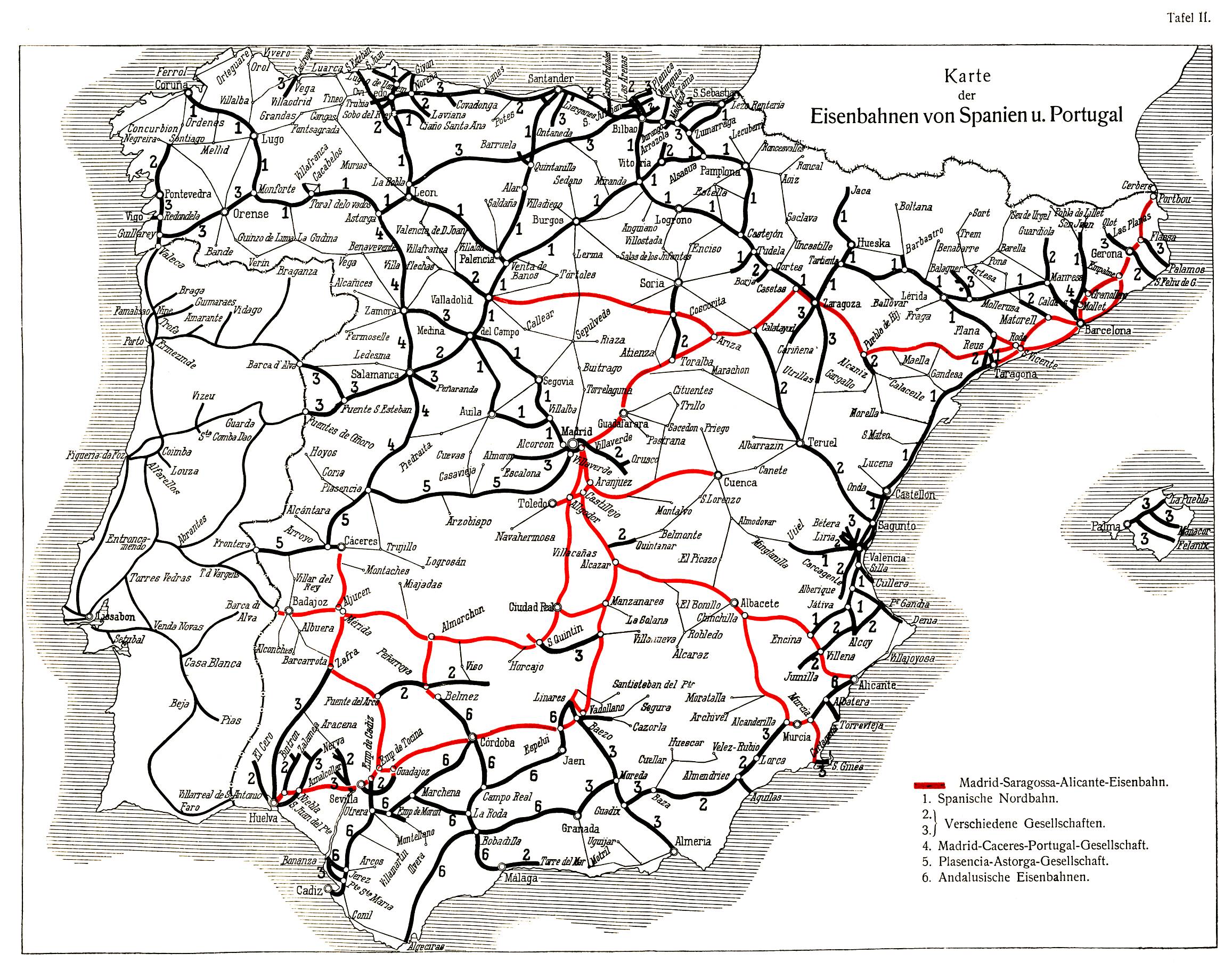
English: Map of the portuguese and spanish railways; taken from Röll, Freiherr von: Enzyklopädie des Eisenbahnwesens, Band 9. Berlin, Wien 1921, S. 85-94.
Deutsch: Karte der portugiesischen und spanischen Eisenbahnen; entnommen aus Röll, Freiherr von: Enzyklopädie des Eisenbahnwesens, Band 9. Berlin, Wien 1921, S. 85-94. |
| Date | |
| Source | zeno.org, |
| Author | Röll, Freiherr von: Enzyklopädie des Eisenbahnwesens, Band 9. Berlin, Wien 1921, S. 85-94. |
Licensing
|
This work is in the public domain in its country of origin and other countries and areas where the copyright term is the author's life plus 70 years or fewer.
| |
| This file has been identified as being free of known restrictions under copyright law, including all related and neighboring rights. | |
| Annotations | This image is annotated: View the annotations at Commons |
File history
Click on a date/time to view the file as it appeared at that time.
| Date/Time | Thumbnail | Dimensions | User | Comment | |
|---|---|---|---|---|---|
| current | 13:41, 6 September 2008 | | 2,313 × 1,821 (753 KB) | Jcornelius | {{Information |Description={{en|1=Map of the portuguese and spanish railways; take from Röll, Freiherr von: Enzyklopädie des Eisenbahnwesens, Band 9. Berlin, Wien 1921, S. 85-94.}} {{de|1=Karte der portugiesischen und spanischen Eisenbahnen; entnommen a |
File usage
Global file usage
The following other wikis use this file:
- Usage on ca.wikipedia.org
- Usage on es.wikipedia.org
- Usage on eu.wikipedia.org