
File:Map of Hispaniola.JPG
Size of this preview: 780 × 600 pixels. Other resolutions: 312 × 240 pixels | 625 × 480 pixels | 999 × 768 pixels | 1,280 × 984 pixels | 2,286 × 1,757 pixels.
Original file (2,286 × 1,757 pixels, file size: 771 KB, MIME type: image/jpeg)
| This is a file from the Wikimedia Commons. Information from its description page there is shown below. Commons is a freely licensed media file repository. You can help. |
Summary
| Description |
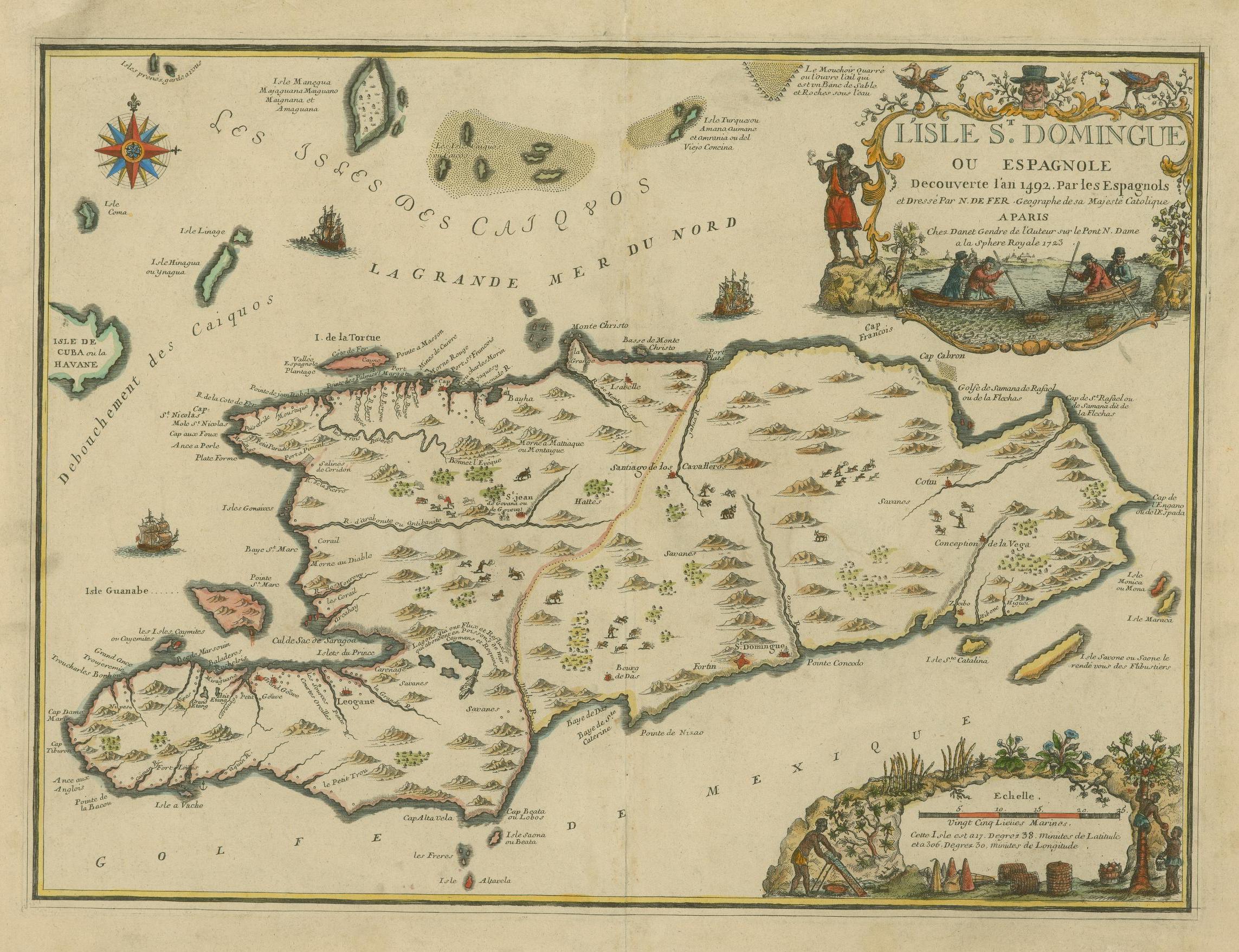
English: The island of Santo Domingo or Hispaniola, discovered in 1492. Français : L'Isle St. Domingue ou Espagnole Decouverte l'an 1492. Par les Espagnols |
||||||||||||||||||||
| Date | |||||||||||||||||||||
| Source |
https://jcb.lunaimaging.com/luna/servlet/s/3l9bzf JCB Map Cabinet Em 723 FeN library catalog record |
||||||||||||||||||||
| Author |
|
||||||||||||||||||||


Licensing
|
This work is in the public domain in its country of origin and other countries and areas where the copyright term is the author's life plus 100 years or fewer. This work is in the public domain in the United States because it was published (or registered with the U.S. Copyright Office) before January 1, 1929. | |
| This file has been identified as being free of known restrictions under copyright law, including all related and neighboring rights. | |
File history
Click on a date/time to view the file as it appeared at that time.
| Date/Time | Thumbnail | Dimensions | User | Comment | |
|---|---|---|---|---|---|
| current | 17:32, 7 September 2018 | | 2,286 × 1,757 (771 KB) | Fernandezmv | High resolution, full color image |
| 07:10, 30 June 2005 |  | 2,556 × 1,960 (1.01 MB) | Schlacke-Heiner | Spanish Map of Hispaniola by 1723, Original in The John Carter Brown Library, Brown University {{PD}} Category:18th century maps |
File usage
The following pages on the English Wikipedia use this file (pages on other projects are not listed):
Global file usage
The following other wikis use this file:
- Usage on ast.wikipedia.org
- Usage on br.wikipedia.org
- Usage on ca.wikipedia.org
- Usage on de.wikipedia.org
- Usage on el.wikipedia.org
- Usage on eo.wikipedia.org
- Usage on es.wikipedia.org
- Usage on fr.wikipedia.org
- Usage on gl.wikipedia.org
- Usage on hsb.wikipedia.org
- Usage on ia.wikipedia.org
- Usage on is.wikipedia.org
- Usage on la.wikipedia.org
- Usage on no.wikipedia.org
- Usage on pt.wikipedia.org
- Usage on ro.wikipedia.org
- Usage on ta.wikipedia.org